-
-


-
Wall Color
in
Uncheck to hide the white line Check to show the white line -
-
.


Frame
Room
Gallery
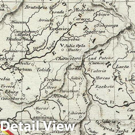
Historic Map : Dufour Map of Spain Under The Roman Empire, 1852, Vintage Wall Art
Historic Map : Dufour Map of Spain Under The Roman Empire, 1852, Vintage Wall Art
Note: Sold out or unavailable
Couldn't load pickup availability
An uncommon and extremely attractive 1852 map of Spain under the Roman empire. The map covers all of Iberia under the Roman Republic from the Atlantic Ocean to the Mediterranean Sea. This includes Hispanic Citerior or Tarraconensis, consisting of the Baetica and Lusitania. Includes the Balearic Islands. Throughout, the map identifies various cities, towns, rivers and assortment of additional topographical details. Although the Romans controlled most of the Iberian Peninsula from about 218 BCe, it took them close to two centuries to fully subjugate the region. The map features a beautiful frame style border. Prepared by A. H. Dufour for publication as plate no. 43 in Maison Basset's 1852 edition of Atlas Illustre Destine a l'enseignement de la Geographie elementaire.
- MUSEUM QUALITY INKS AND PAPER: Printed on thick 192gsm heavyweight matte paper with archival giclee inks, this historic fine art will decorate your wall for years to come.
- VINTAGE MAP REPRODUCTION: Add style to any room's decor with this beautiful print. Whether your interior design is modern or classic, a map is never out of fashion.
- ATTENTION TO DETAIL: We edit every antique map for image quality, color and vibrance, so it can look its best while retaining historical character. Makes a great gift!
- FRAME READY: Your unframed poster will arrive crease-free, rolled in a sturdy mailing tube. Many maps fit easy-to-find standard size frames 16x20, 16x24, 18x24, 24x30, 24x36, saving on custom framing.
- Watermarks will not appear in the printed picture. Some blemishes, tears, or stamps may be removed from the final print.
Why choose Historic Pictoric
Every artwork we offer is carefully edited by our small but dedicated team of image professionals, ensuring each detail is perfect. We print every order to demand right here in the USA, treating every piece with the same care and attention we would give our own work. From editing to printing to packaging, we take pride in delivering artwork that meets our high standards—and we love knowing it’s heading to a home where it will be appreciated.