-
-


-
Wall Color
in
Uncheck to hide the white line Check to show the white line -
-
.


Frame
Room
Gallery
Historic Map : La Feuille Map of France, 1747, Vintage Wall Art
Historic Map : La Feuille Map of France, 1747, Vintage Wall Art
Note: Sold out or unavailable
Couldn't load pickup availability
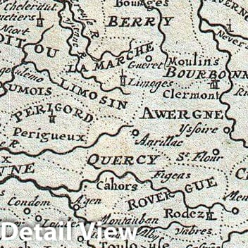
A stunning map of France first drawn by Daniel de la Feuille in 1706. Depicts all of France as well as parts of Italy, England, Spain, Switzerland, Belgium and Germany. Flanked on either side and along the bottom by plans and views of important French cities. From top left these include: Grenoble, Loulouzf, Orleans, Renne (Rennes), Lion, Paris, Rheims, Rouan (Rouen), Bourdeau (Bordeaux), Aix, Amiens and Dijon. Title cartouche in the lower left quadrant surrounded by the armorial crests of seventeen important French regions. An additional seven crests appear in the upper right quadrant. Alternate Dutch language title in upper margin. This is Paul de la Feuille's 1747 reissue of his father Daniel's 1706 map. Prepared for issue as plate no. 25 in J. Ratelband's 1747 Geographisch-Toneel .
- MUSEUM QUALITY INKS AND PAPER: Printed on thick 192gsm heavyweight matte paper with archival giclee inks, this historic fine art will decorate your wall for years to come.
- VINTAGE MAP REPRODUCTION: Add style to any room's decor with this beautiful print. Whether your interior design is modern or classic, a map is never out of fashion.
- ATTENTION TO DETAIL: We edit every antique map for image quality, color and vibrance, so it can look its best while retaining historical character. Makes a great gift!
- FRAME READY: Your unframed poster will arrive crease-free, rolled in a sturdy mailing tube. Many maps fit easy-to-find standard size frames 16x20, 16x24, 18x24, 24x30, 24x36, saving on custom framing.
- Watermarks will not appear in the printed picture. Some blemishes, tears, or stamps may be removed from the final print.
Why choose Historic Pictoric
Every artwork we offer is carefully edited by our small but dedicated team of image professionals, ensuring each detail is perfect. We print every order to demand right here in the USA, treating every piece with the same care and attention we would give our own work. From editing to printing to packaging, we take pride in delivering artwork that meets our high standards—and we love knowing it’s heading to a home where it will be appreciated.