-
-


-
Wall Color
in
Uncheck to hide the white line Check to show the white line -
-
.


Frame
Room
Gallery
Historic Wall Map : Jamaica, CaribbeanCuba Insula. Hispaniola Insula 1636 , Vintage Wall Art
Historic Wall Map : Jamaica, CaribbeanCuba Insula. Hispaniola Insula 1636 , Vintage Wall Art
Note: Sold out or unavailable
Couldn't load pickup availability
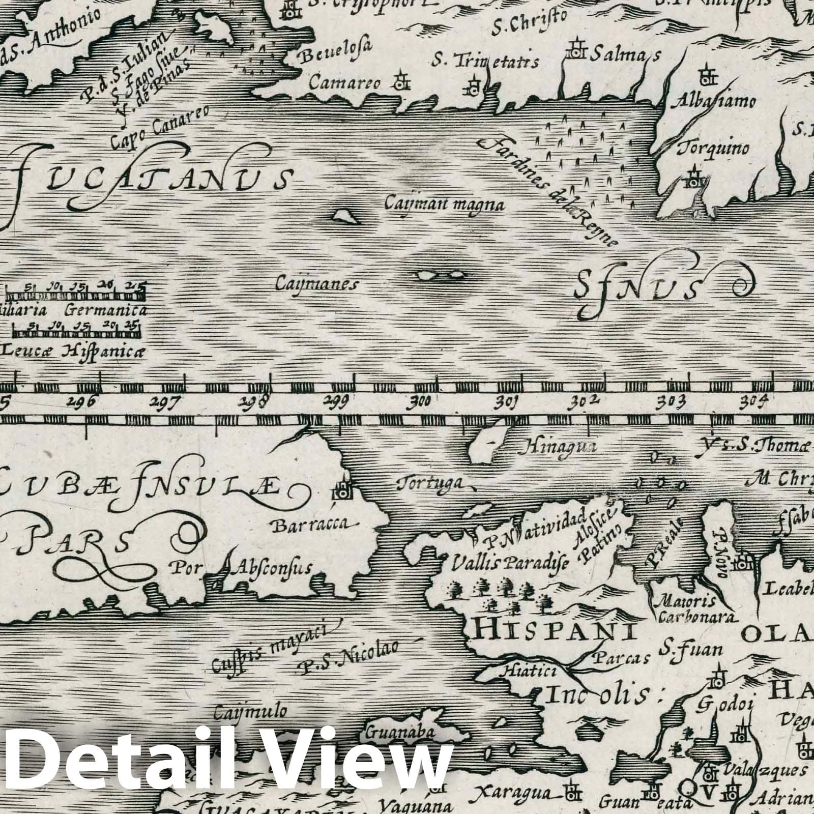
Cuba Insula. Hispaniola Insula. (to accompany) Atlas sive Cosmographicae Meditationes de Fabrica mundi et fabricati figura. De novo multis in locis emendatus novisque tabulis auctus. Amsterodami, apud Iohannem Ianssonium van Waesberge. Anno, 1673. (insets) Insula Iamaica. (with) Ins. S. Ioannis. (with) Is. Margareta. (with) Havana portus. | Atlas sive Cosmographicae Meditationes de Fabrica mundi et fabricati figura. De novo multis in locis emendatus novisque tabulis auctus. Amsterodami, apud Iohannem Ianssonium van Waesberge. Anno, 1673. | First reworked edition of Mercator's Atlas Minor issued by the Janssonius heirs (Johannes Janssonius van Waesberge) in 1673, without text or printed index. With engraved architectural and emblematic title page, and 183 copperplate engraved maps. Printed from the plates of the Cloppenburg editions of the Atlas Minor (1630, 1632, 1636), with a new map of the United Provinces and additional decorative elements to some maps, along with some updates to the maps. This edition of Mercator's 'Atlas'... was a changed format edition. Its newly engraved maps fell in between the folio maps in the Mercator-Hondius Atlas and the Atlas Minor. The Cloppenburg edition seems to have been suppressed after 1636. It was continued with this copy after 1673 by the Janssonius heirs. Because the maps are all take from the Cloppenburg plates of the 1636 edition, these maps are dated 1636, while the atlas is dated (Pub Date) as 1673. The maps include decorative cartouches, latitudinal and longitudinal lines, coats of arms, compass rose, and show political boundaries, cities, towns, topography, vegetation, waterways and landmarks. Relief shown pictorially.
We print high quality reproductions of historical maps, photographs and prints. Some of these images may show signs of wear and tear - we believe that in many cases this contributes to the aesthetics of the item.
- MUSEUM QUALITY INKS AND PAPER: Printed on thick 192gsm heavyweight matte paper with archival giclee inks, this historic fine art will decorate your wall for years to come.
- VINTAGE MAP REPRODUCTION: Add style to any room's decor with this beautiful print. Whether your interior design is modern or classic, a map is never out of fashion.
- ATTENTION TO DETAIL: We edit every antique map for image quality, color and vibrance, so it can look its best while retaining historical character. Makes a great gift!
- FRAME READY: Your unframed poster will arrive crease-free, rolled in a sturdy mailing tube. Many maps fit easy-to-find standard size frames 16x20, 16x24, 18x24, 24x30, 24x36, saving on custom framing.
- Watermarks will not appear in the printed picture. Some blemishes, tears, or stamps may be removed from the final print.
Why choose Historic Pictoric
Every artwork we offer is carefully edited by our small but dedicated team of image professionals, ensuring each detail is perfect. We print every order to demand right here in the USA, treating every piece with the same care and attention we would give our own work. From editing to printing to packaging, we take pride in delivering artwork that meets our high standards—and we love knowing it’s heading to a home where it will be appreciated.