icon

Free Shipping     |     Satisfaction Guaranteed

Antique Maps

Showing products 1 - 80 of 252
Sort by:

Historic Map : Bogue Antique Map or Plan of The City of Seattle, Washington, 1911, Vintage Wall Art

This is a rare and important 1911 map or plan of the city of Seattle by Virgil G. Bogue. This map, present the proposed ‘Bogue Plan' and covers the city...
From: $49.99

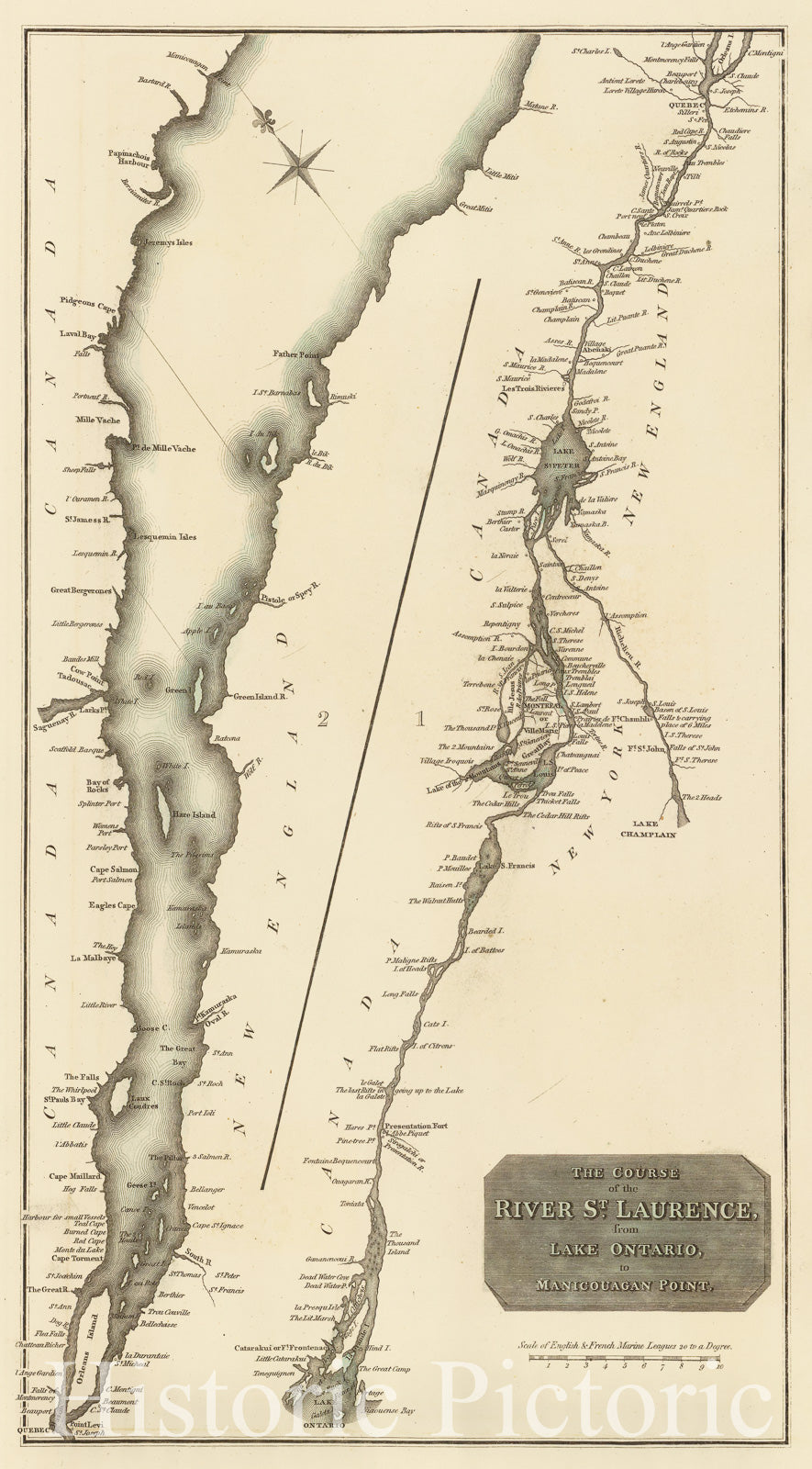
Historic Map : Thomson Antique Map of The St. Lawrence River, Canada, 1814, Vintage Wall Art

John Thomson's 1814 map of the St. Lawrence River from Lake Ontario to Manicouagan Point, Quebec, Canada. Divided into two sections. The left section covers the river from Manicouagan Point...
From: $49.99

Historic Map : 1834 Italle Antique Mappa Nova : Vintage Wall Art

Vintage Map | 1834 Italle Antique Mappa Nova | Delamarche, Félix
From: $49.99

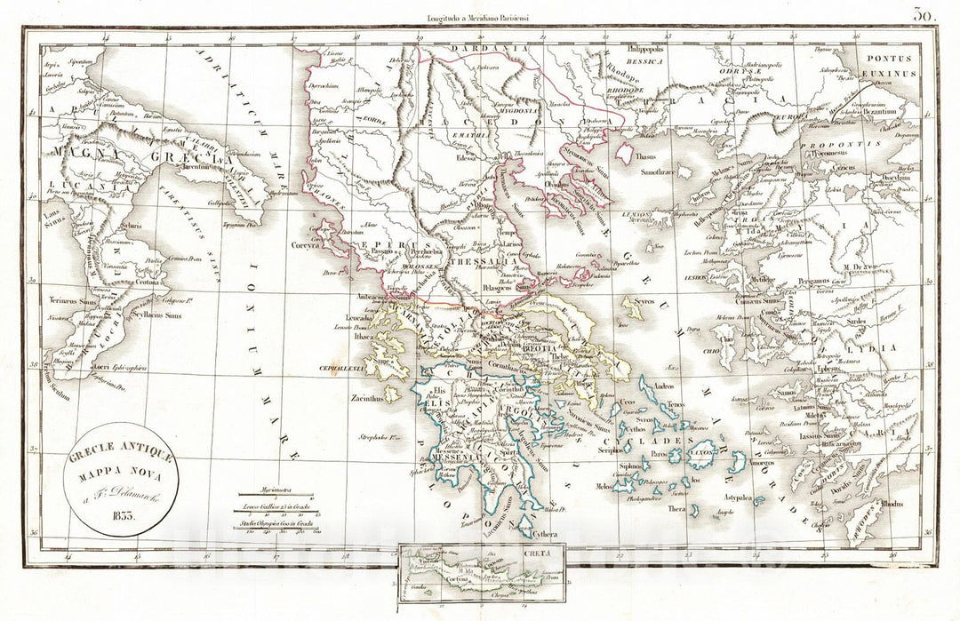
Historic Map : 1834 Graeciae Antique Mappa Nova : Vintage Wall Art

Vintage Map | 1834 Graeciae Antique Mappa Nova | Delamarche, Félix
From: $49.99

Historic Map - Italia Cursoria Seu Tabula Geographica in qua omnes viae angariae et Stationes Veredariorum ordinariae per totam/Antique Map of Italy, 1760 - Vintage Wall Art

Italia Cursoria Seu Tabula Geographica in qua omnes viae angariae et Stationes Veredariorum ordinariae per totam / Antique Map of Italy, 1760We print high quality reproductions of historical maps, photographs,...
From: $49.99

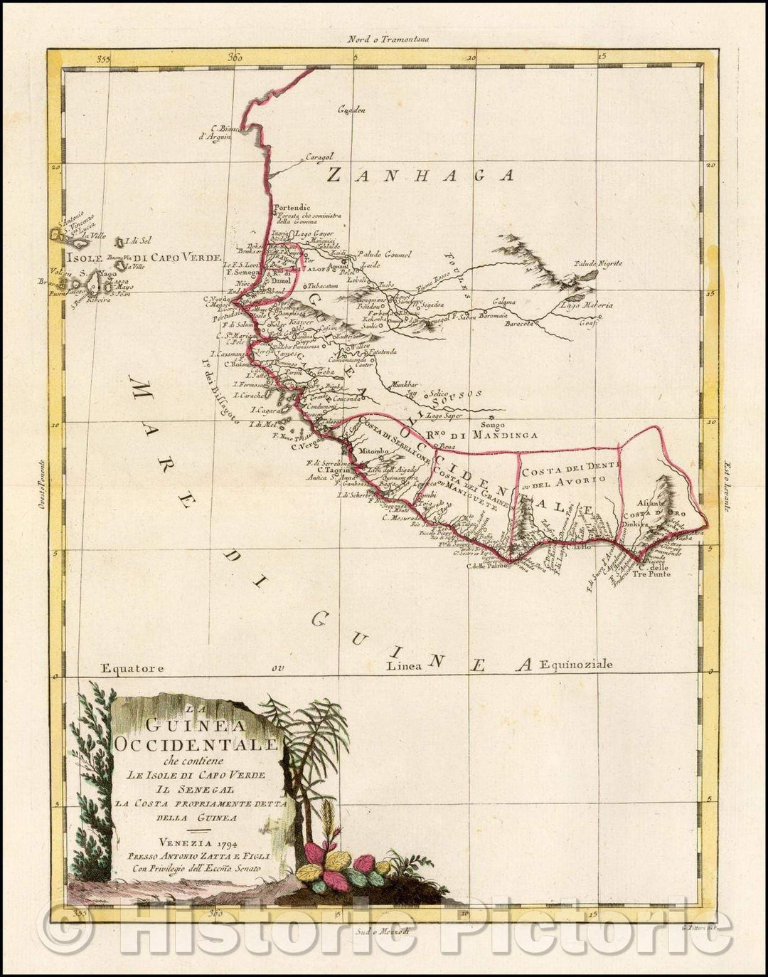
Historic Map - La Guinea Occidentale che contiene Le Isole Di Capo Verde Il Senegal La Costa Propriamente Dlla Guinea/Antique Map of West Africa, 1794 - Vintage Wall Art

La Guinea Occidentale che contiene Le Isole Di Capo Verde Il Senegal La Costa Propriamente Dlla Guinea / Antique Map of West Africa, 1794We print high quality reproductions of historical...
From: $49.99

Historic Map : Italy, Italiae Antique Mappa Nova, 1825 , Vintage Wall Art

Italiae Antique Mappa Nova ... 1825. | Atlas De La Geographie Ancienne et moderne, Adopte Par Le Conseil Royal De l'Instruction Publique, A l'usage des Colleges Royaux et des Maisons...
From: $34.99

Historic Map : U.S. Coast Survey Antique Map or Chart of The Coast of Washington anArtegon, Version 2, 1851, Vintage Wall Art

This is an attractive 1851 U.S. Coast Survey chart of the Washington and Oregon Coast. It covers from Cape Arago in Oregon north to the Columbia River and includes Astoria,...
From: $49.99

Historic Map : U.S. Coast Survey Antique Map or Chart of The Coast of Washington anArtegon, 1851, Vintage Wall Art

This is an attractive 1851 U.S. Coast Survey chart of the Washington and Oregon Coast. It covers from Cape Arago in Oregon north to the Columbia River and includes Astoria,...
From: $49.99

Historic Map : Adrichem Antique Map of The Tribe of Simeon, Israel (South of Canaan), 1590, Vintage Wall Art

This is a fine example of Christian van Adrichem's rare 1590 map of the lands granted to the Tribe of Simeon at the time of Joshua's division of the Twelve...
From: $59.99

Historic Map : Adrichem Antique Map of The Tribe of Naphtali, Israel (Sea of Galilee, Golan Heights, and Lands North) Version 2, 1590, Vintage Wall Art

Christian van Adrichem's rare 1590 map of the lands granted to the Tribe of Naphtali at the time of Joshua's division of the Twelve Tribes. The map is oriented to...
From: $49.99

Historic Map : Adrichem Antique Map of The Tribe of GAD, Israel (Sea of Galilee and Lands South) Version 2, 1590, Vintage Wall Art

This is a fine example of Christian van Adrichem's rare 1590 map of the lands granted to the Tribe of Gad at the time of Joshua's division of the Twelve...
From: $49.99

Historic Map : Adrichem Antique Map of Tribe of Asher, Israel (Western Galilee, Mount Hermon), 1590, Vintage Wall Art

This is a beautiful example of Christian van Adrichom's rare 1590 map of the lands granted to the Tribe of Asher at the time of Joshua's division of the Twelve...
From: $49.99

Historic Map : Antique Map of Portland, Maine, 1885, Vintage Wall Art

This is a rare map of Portland issued c.1885. It covers downtown Portland and Casco Bay. Towns of Deering and Cape Elizabeth are noted along with various islands in Casco...
From: $49.99

Historic Map : U.S. Coast Survey Chart or Antique Map of Plymouth Harbor, Massachusetts, 1854, Vintage Wall Art

This is a beautiful example of the U.S. Coast Survey's 1854 nautical chart or maritime map of Plymouth Harbor, Massachusetts. It covers the important harbor located just south of Boston...
From: $34.99

Historic Map : Geographia Company City Plan or Antique Map of New York City (Upper Manhattan and The Bronin x), 1940, Vintage Wall Art

This is an excellent map of New York City by Alexander Gross dating to c.1940. The map covers the northern portions of the borough of Manhattan from 102nd Street to...
From: $49.99

Historic Map : Adrichem Antique Map of The Tribe of Naphtali, Israel (Sea of Galilee, Golan Heights, and Lands North), 1590, Vintage Wall Art

Christian van Adrichem's rare 1590 map of the lands granted to the Tribe of Naphtali at the time of Joshua's division of the Twelve Tribes. The map is oriented to...
From: $49.99

Historic Map : Mitchell Antique Map of Northern Italy (Tuscany, Venice, Milan), 1854, Vintage Wall Art

This is a fine example of Thomas Cowperthwait and S. A. Mitchell's 1854 map of the north part of Italy. Centered on Tuscany, this map covers from Lombardy to the...
From: $49.99

Historic Map : Adrichem Antique Map of The Tribe of GAD, Israel (Sea of Galilee and Lands South), 1590, Vintage Wall Art

Christian van Adrichem's rare 1590 map of the lands granted to the Tribe of Gad at the time of Joshua's division of the Twelve Tribes. The map is oriented to...
From: $49.99

Historic Map : National Publishing Company Railroad Antique Map of Massachusetts, Rhode Island and Connecticut, 1902, Vintage Wall Art

This is a large and impressive relic of the great age of American Railroads. This dramatic map, issued by the National Publishing Company in 1902, covers the states of Massachusetts,...
From: $49.99

Historic Map : USGS Geologic Antique Map of Shoshone Geyser Basin, Yellowstone National Park, 1904, Vintage Wall Art

Arnold Hague's 1904 geological survey map of the spectacular Shoshone Geyser Basin in Yellowstone National Park, Wyoming. Centered on the Shoshone Creek, the map covers the basin from the Shoshone...
From: $49.99

Historic Map : USGS Geologic Antique Map of Shoshone, Yellowstone National Park, 1904, Vintage Wall Art

Arnold Hague's 1904 geological survey map of the spectacular Shoshone Region in Yellowstone National Park, Wyoming. Centered on Pitchstone Plateau, the map covers from Snake River northwards, along the river,...
From: $49.99

Historic Map : USGS Topographic Antique Map of Mammoth Springs Travertine Terraces, Yellowstone National Park, 1904, Vintage Wall Art

Arnold Hague's 1904 topographical survey map of the spectacular Mammoth Hot Springs Travertine Terraces in Yellowstone National Park, Wyoming. Centered on the Cleopatra Spring in Minerva Terrace, this detailed map...
From: $49.99

Historic Map : USGS Geologic Antique Map of EIN xcelsior Geyser Basin, Yellowstone National Park, 1904, Vintage Wall Art

Arnold Hague's 1904 geological survey map of the spectacular excelsior Geyser Basin in Yellowstone National Park, Wyoming. Focusing on the excelsior Geyser, the map covers the Midway Geyser Basin from...
From: $49.99

Historic Map : Black Antique Map of The World on Mercator's Projection, 1844, Vintage Wall Art

This is a fine example of Adam and Charles Black's 1844 map of the world on Mercator's Projection. An interesting map of the world issued just as most of the...
From: $49.99

Historic Map : Mitchell Antique Map of The World in Hemispheres, 1866, Vintage Wall Art

This is a beautiful example of S. A. Mitchell Jr.'s 1866 decorative double hemisphere map of the world. Depicts the world on a hemisphere projection. The upper part of the...
From: $49.99

Historic Map : Gabriel Ramirez Antique Map of The World in Hemispheres, 1754, Vintage Wall Art

This is a scarce 1754 map of the World in two hemispheres by Gabriel Ramirez. It covers the western and eastern hemispheres and depicts the world as it was understood...
From: $49.99

Historic Map : Ewing Antique Map of The World in Hemispheres, 1845, Vintage Wall Art

This is a fine example of Thomas Ewing's 1845 map of the World in two hemispheres. Both the Western and Eastern Hemispheres are drawn and offer a fascinating snapshot of...
From: $49.99

Historic Map : U. S. Geological Corps Geological Antique Map of Wisconsin, Iowa and Minnesota, 1851, Vintage Wall Art

This is a beautiful large geological map of Wisconsin, Iowa and Minnesota by the United States Geological Corps. It covers from the Missouri River east as far as Lake Michigan...
From: $49.99

Historic Map : Wilkinson Antique Map of Westphalia, Germany, 1793, Vintage Wall Art

A finely detailed 1793 map of Westphalia by Robert Wilkinson.  While the name 'Westphalia' is used for several different overlapping areas in central to western Germany, this map shows the...
From: $49.99

Historic Map : Weiland Antique Map of The West Indies, 1825, Vintage Wall Art

This is a scarce separate-issue 1825 map of the West Indies by C. F. Weiland. It covers from the southern part of Florida and the Bahamas south through the Caribbean...
From: $49.99

Historic Map : Warren Antique Map of The Western Hemisphere, 1879, Vintage Wall Art

This is an example of David M. Warren's 1879 map of the Western Hemisphere. Offering a fascinating snapshot of the world during a period of rapid globalization and discovery, this...
From: $49.99

Historic Map : Burr Antique Map of The Western Hemisphere, 1833, Vintage Wall Art

This is an attractive first edition 1835 David Burr map of the Western Hemisphere By David Burr. It covers North America, South America, West Indies and most of Polynesia including...
From: $49.99

Historic Map : Norris Peters Antique Map of Washington D.C. Showing Western Union Telegraph Lines, 1891, Vintage Wall Art

A fascinating 1891 map of Washington D.C. illustrating Western Union Telegraph lines and office. This large map covers from the Rock Creek Cemetery to Haines Point and from Georgetown to...
From: $34.99

Historic Map : Imray Antique Map Nautical Chart of The East Coast of The United States: New York to Florida, 1855, Vintage Wall Art

An extremely scarce, highly decorative, and monumentally proportioned 1855 sea chart or maritime map detailing the eastern coast of the United States from New York City to southern Florida (roughly...
From: $49.99

Historic Map : Rand McNally Antique Map of The United States Showing Change in Population, 1892, Vintage Wall Art

An attractive 1892 Rand McNally and Company map of the United States, showing the increase and decrease of population from 1880 to 1890. Divided by color coding into four degrees...
From: $49.99

Historic Map : GRAF Antique Map of The United States, 1886, Vintage Wall Art

This is a rare 1886 example of C. Graf's map of the United States of America. The map covers the eastern part of the United States from eastern Texas to...
From: $49.99

Historic Map : Beers Antique Map of The United States, 1873, Vintage Wall Art

An attractive 1873 map of the United States issued by Fredrick Beers. This map covers the entire United States from Atlantic to Pacific, Canada to Mexico. It is color coded...
From: $49.99

Historic Map : Burr Antique Map of New York City and Vicinity (25 Miles Around), 1835, Vintage Wall Art

This is an appealing 1835 first edition map of New York City and its vicinity by David H. Burr. It extends twenty-five miles around New York City, covering from Rockland...
From: $49.99

Historic Map : Vaugondy Antique Map of European Turkey, Greece and The Balkans, 1755, Vintage Wall Art

This is a beautiful map of Greece from De Vaugondy's 1752 Atlas Universal. Depicts the whole of Greece from Bosnia and Croatia east to through Bulgaria and Romania to the...
From: $34.99

Historic Map : Imperial Japanese Railway Antique Map of ChingTao or Qingdao or Tsingtao, China, 1924, Vintage Wall Art

This is a beautiful 1924 map of Qingdao or Tsingtao or Chingtao, located in the eastern Shandong Province of China, issued by the Imperial Japanese Government Railways. The map depicts...
From: $49.99

Historic Map : Meyer Antique Map of Thuringia (The Thuringian States), Germany, 1849, Vintage Wall Art

This is a scarce 1849 map of Sain xony, the States of Thuringia and neighboring countries by Joseph Meyer. It covers the region from Magdeburg south to Bamberg and from...
From: $49.99

Historic Map : De Wit Antique Map of Central Italy (Tuscany and The Papal States), 1721, Vintage Wall Art

This is an attractive c.1721 map of depicting central Italy and the regions of Tuscany and the States of the Church or the Papal States by Frederik De Wit. It...
From: $49.99

Historic Map : Cellarius Antique Map of The Ptolmaic Lunar System, 1708, Vintage Wall Art

A fine 1708 Andreas Cellarius celestial chart illustrating the Claudius Ptolemy model of lunar motion. The chart illustrates the lunar epicycles as the moon revolves along various orbits. The central...
From: $49.99