icon

Free Shipping     |     Satisfaction Guaranteed

Colorado State Maps

Showing products 1 - 57 of 57
Sort by:

Historic Map : Department of The Interior General Land office Map - State of Colorado. 1879 - Vintage Wall Art

Department Of The Interior General Land Office J.A. Williamson, Commissioner. State of Colorado. 1879. Compiled from the official Records of the General Land Office and other sources by C. Roeser,...
From: $49.99

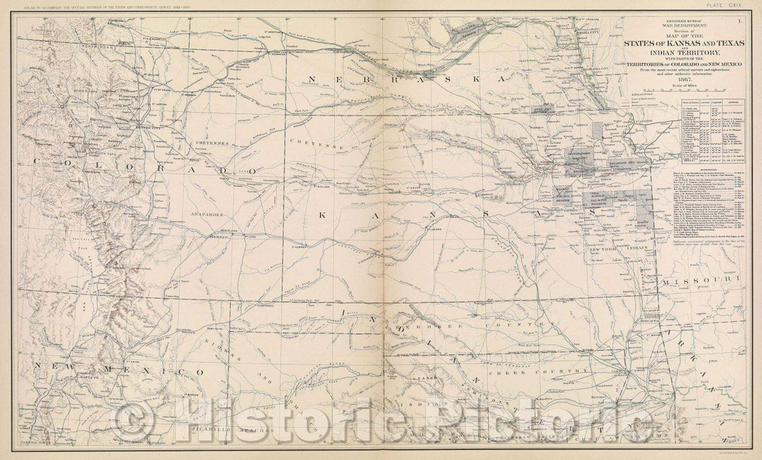
Historic Map : Engineer Bureau War Department. Section of map of the states of Kansas and Texas and Indian territory, with parts of the territories of Colorado, 1867 , Vintage Wall Art

Engineer Bureau War Department. Section of map of the states of Kansas and Texas and Indian territory, with parts of the territories of Colorado, 1867
From: $49.99

Historic Map : Map of Colorado Territory, United States, 1867 , Vintage Wall Art

Map of Colorado Territory, United States, 1867
From: $49.99

Historic Map : United States Maps, Colorado 1894 , Vintage Wall Art

United States Maps, Colorado 1894
From: $49.99

Map : United States 1951, Automobile road map of the Indian Country : embracing portions of Arizona, New Mexico, Utah and Colorado , Antique Vintage Reproduction

Automobile road map of the Indian Country : embracing portions of Arizona, New Mexico, Utah and Colorado / copyrighted Automobile Club of Southern CaliforniaWe print high quality reproductions of historical...
From: $49.99

Map : Colorado 1912, State of Colorado : lands designated by the Secretary of the Interior as subject to entry under the provisions of the Enlarged Homestead Act

State of Colorado : lands designated by the Secretary of the Interior as subject to entry under the provisions of the Enlarged Homestead Act / compiled by A.F. Dinsmore ;...
From: $49.99

Map : Colorado 1892, State of Colorado , Antique Vintage Reproduction

State of Colorado / Department of the Interior, General Land Office ; compiled and drawn by A.F. Dinsmore ; traced and lettered by Wm. NaylorWe print high quality reproductions of...
From: $49.99

Map : Colorado 1880, Nell's new topographical & township map of the state of Colorado , Antique Vintage Reproduction

Nell's new topographical & township map of the state of Colorado / compiled from U.S. Government surveys and other authentic sourcesWe print high quality reproductions of historical maps, photographs, prints,...
From: $49.99

Map : Colorado 1889, Nell's topographical map of the state of Colorado , Antique Vintage Reproduction

Nell's topographical map of the state of Colorado / Louis NellWe print high quality reproductions of historical maps, photographs, prints, etc. Because of their historical nature, some of these images...
From: $49.99

Map : Colorado 1905, State of Colorado : compiled from the official records of the General Land Office and other sources under the direction of Frank Bond

State of Colorado : compiled from the official records of the General Land Office and other sources under the direction of Frank Bond / U.S. General Land Office ; compiled...
From: $49.99

Historic Map : Colorado 1916, State of Colorado : lands designated by the Secretary of the Interior under the provisions of the Enlarged Homestead Acts , Antique Vintage Reproduction

State of Colorado : lands designated by the Secretary of the Interior under the provisions of the Enlarged Homestead Acts / compiled by A.F. Dinsmore ; traced and lettered by...
From: $34.99

Map : United States 1985, Colorado River storage project, interconnected transmission system, Salt Lake City area , Antique Vintage Reproduction

Colorado River storage project, interconnected transmission system, Salt Lake City area / United States Department of Energy, Western Area Power AdministrationWe print high quality reproductions of historical maps, photographs, prints,...
From: $49.99

Map : United States 1922, [Map of the Colorado to Gulf Highway]., Antique Vintage Reproduction

[Map of the Colorado to Gulf Highway].We print high quality reproductions of historical maps, photographs, prints, etc. Because of their historical nature, some of these images may show signs of...
From: $49.99

Map : Colorado 1919, National highways map of the state of Colorado : showing thirty-seven hundred miles of national highways , Antique Vintage Reproduction

National highways map of the state of Colorado : showing thirty-seven hundred miles of national highways / produced by the National Highways Association, Washington, D.C. ; John C. Mulford, chief...
From: $34.99

Map : Colorado 1910, Topographical birds-eye view the State of Colorado , Antique Vintage Reproduction

Topographical birds-eye view the State of Colorado / compiled, engraved and published by the Clason Map CoWe print high quality reproductions of historical maps, photographs, prints, etc. Because of their...
From: $49.99

Map : United States, West and Middle West 1860, Kansas, Nebraska, Minnesota, Indian Territory, Dakota, Colorado, Antique Vintage Reproduction

Kansas, Nebraska, Minnesota, Indian Territory, Dakota, ColoradoWe print high quality reproductions of historical maps, photographs, prints, etc. Because of their historical nature, some of these images may show signs of...
From: $49.99

Blueprint Isometric and maps - Grand Valley Diversion Dam, Half a Mile North of Intersection of I-70 & Colorado State Route 65, Cameo, Mesa County, CO

Grand Valley Diversion Dam, Half a mile north of intersection of I-70 & Colorado State Route 65, Cameo, Mesa County, CO
From: $34.99

Map : Surface water supply of the United States, 1961-65, Part 9. Colorado River basin, Volume 3. lower Colorado River basin, 1970 Cartography Wall Art :

Surface water supply of the United States, 1961-65, Part 9. Colorado River basin, Volume 3. lower Colorado River basinWe print high quality reproductions of historical maps, photographs, prints, etc. Because...
From: $49.99

Map : Surface water supply of the United States, 1961-65, Part 9. Colorado River basin, Volume 1. Colorado River basin above Green River, 1970 Cartography Wall Art :

Surface water supply of the United States, 1961-65, Part 9. Colorado River basin, Volume 1. Colorado River basin above Green RiverWe print high quality reproductions of historical maps, photographs, prints,...
From: $49.99

Map : Oxidized zinc deposits of the United States: part 3. Colorado, 1964 Cartography Wall Art :

Oxidized zinc deposits of the United States: part 3. ColoradoWe print high quality reproductions of historical maps, photographs, prints, etc. Because of their historical nature, some of these images may...
From: $34.99

Historic 1879 Map - Indexed map of Colorado Showing The Railroads in The State, and The Express Company Doing Business Over Each, Also Counties and Rivers.

Indexed map of Colorado showing the railroads in the state, and the express company doing business over each, also counties and rivers.We print high quality reproductions of historical maps, photographs,...
From: $49.99

Historic 1878 Map - Colton's New sectional map of The State of Colorado.

Colton's new sectional map of the State of Colorado.We print high quality reproductions of historical maps, photographs, prints, etc. Because of their historical nature, some of these images may show...
From: $49.99

Historic 1870 Map - Atlas of Marshall Co. and The State of Illinois - Map of Utah, Arizona, New Mexico, Knasas, Colorado - Atlas of Marshall County and The State of Illinois

Atlas of Marshall Co. and the state of Illinois : to which is added an atlas of the United States, maps of the hemispheres &c. &c. &c.We print high quality...
From: $49.99

Historic 1870 Map - Atlas of Kendall Co. and The State of Illinois - Utah, Arizona, New Mexico, Kansas, Colorado & Indian Territory

Atlas of Kendall Co. and the state of Illinois : to which is added an atlas of the United States, maps of the hemispheres &c. &c. &c.We print high quality...
From: $49.99

1972 State Bridge, CO - Colorado - USGS Topographic Map

1972 State Bridge, CO - Colorado - USGS Topographic Map
From: $49.99

Historic Map - Colorful Colorado, 1947, Colorado State Highway Department - Vintage Wall Art

Colorful Colorado , 1947, Colorado State Highway Department
From: $49.99

Historic Map - Nell's Topographical & Township Map of the State of Colorado. E. Besly & Co. Publishers, Denver, 1892, Louis Nell - Vintage Wall Art

Nell's Topographical & Township Map of the State of Colorado. E. Besly & Co. Publishers, Denver. , 1892, Louis NellWe print high quality reproductions of historical maps, photographs, prints, etc....
From: $49.99

Historic Map - of That Portion of the Boundary between the United States and Mexico From the Pacific Coast To The Junction of the Gila and Colorado Rivers, 1855 - Vintage Wall Art

of That Portion of the Boundary between the United States and Mexico From the Pacific Coast To The Junction of the Gila and Colorado Rivers , 1855We print high quality...
From: $34.99

Historic Map - Post Route Map of the State of Colorado Showing Post Offices Mail Routes In Operation On The 1st of January, 1923, 1923, United States GPO - Vintage Wall Art

Post Route Map of the State of Colorado Showing Post Offices Mail Routes In Operation On The 1st of January, 1923 , 1923, United States GPOWe print high quality reproductions...
From: $49.99

Historic Map : Post Route Map of the State of Colorado Showing Post Offices With The Intermediate Distances On Mail Routes, 1924, Vintage Wall Art

Post Route Map of the State of Colorado Showing Post Offices With The Intermediate Distances On Mail Routes, 1924
From: $49.99

Historic Map : Map of the State of Colorado. Compiled from the official Records of the General Land Office and other sources, 192, 1902, General Land Office, Vintage Wall Art

Map of the State of Colorado. Compiled from the official Records of the General Land Office and other sources, 192, 1902, General Land Office
From: $49.99

Historic Map : The Mammoth Map of the United States Sheet NO. 9 (Colorado, New Mexico etc.), c1877, , Vintage Wall Art

The Mammoth Map of the United States Sheet NO. 9 (Colorado, New Mexico etc.), c1877,
From: $49.99

Historic Map : State of Colorado. Compiled from the official Records of the General Land Office and other sources 1905, 1905, , Vintage Wall Art

State of Colorado. Compiled from the official Records of the General Land Office and other sources 1905, 1905,
From: $49.99

Historic Map : System of Main Roads in Colorado Now Open To Travel Revised By The State Highway Commission of Colorado, c1916, The Clason Map Company, Vintage Wall Art

System of Main Roads in Colorado Now Open To Travel Revised By The State Highway Commission of Colorado, c1916, The Clason Map Company
From: $49.99

Historic Map - Nell's Topographical & Township Map of the State of Colorado. Hamilton & Kendrick. Denver, 1895, Louis Nell - Vintage Wall Art

Nell's Topographical & Township Map of the State of Colorado. Hamilton & Kendrick. Denver, ., 1895, Louis NellWe print high quality reproductions of historical maps, photographs, prints, etc. Because of...
From: $49.99

Historic Map - Nell's Topographical Map of the State of Colorado, 1902, Louis Nell - Vintage Wall Art

Nell's Topographical Map of the State of Colorado , 1902, Louis NellWe print high quality reproductions of historical maps, photographs, prints, etc. Because of their historical nature, some of these...
From: $49.99

Historic Map - Nell's New Topographical & Township Map of the State of Colorado, 1885, Louis Nell - Vintage Wall Art

Nell's New Topographical & Township Map of the State of Colorado , 1885, Louis NellWe print high quality reproductions of historical maps, photographs, prints, etc. Because of their historical nature,...
From: $49.99

Historic Map : Topographic Map of Colorado 1913, 1913, Colorado State Geological Survey, Vintage Wall Art

Topographic Map of Colorado 1913, 1913, Colorado State Geological Survey
From: $49.99

Historic Map : State of Colorado. 1879, 1879, U.S. General Land Office, Vintage Wall Art

State of Colorado. 1879, 1879, U.S. General Land Office
From: $34.99

Historic Map : Section of Map of the States of Kansas and Texas and Indian Territory, with parts of the Territories of Colorado and Mexico, 1867, 1867, , Vintage Wall Art

Section of Map of the States of Kansas and Texas and Indian Territory, with parts of the Territories of Colorado and Mexico, 1867, 1867,
From: $49.99

Historic Map : Nell's New Topographical & Township Map of the State of Colorado Compiled from U.S. Government Surveys, 1885, , Vintage Wall Art

Nell's New Topographical & Township Map of the State of Colorado Compiled from U.S. Government Surveys, 1885,
From: $49.99

Historic Map : (Nebraska, Colorado) Railroad Map of the United States., 1891, Vintage Wall Art

(Nebraska, Colorado) Railroad Map of the United States., 1891
From: $49.99

Historic Map : Map of the State of Colorado., 1884, Vintage Wall Art

Map of the State of Colorado., 1884, Vintage Wall Art
From: $49.99

Historic Map : Berta and Elmer Hader's Picture Book of The States. Colorado. Wyoming, 1932 Atlas - Vintage Wall Art

Berta and Elmer Hader's Picture Book of The States. Colorado. Wyoming, 1932 Atlas
From: $49.99

Historic Map - Topographical Map of The State of Colorado, 1905 - Vintage Wall Art

Nell's Topographical Map Of The State Of Colorado. The Kendrick Book & Stationery Co. Denver, 1905. C.A. Kendrick, Pres. H.E. Bellamy, Vice Pres. Copyright by Louis Nell, Denver, Colo. 1903....
From: $49.99

Historic Map : Cover: Nell's topographical map of the state of Colorado, 1895 - Vintage Wall Art

Nell's topographical map of the state of Colorado. Hamilton & Kendrick, Denver. 1895. Copyright by Louis Nell, Denver, Colo. 1895. Maps of every description prepared by Louis Nell, Denver. |...
From: $49.99

Historic Map : Post route map of the state of Colorado, 1923 - Vintage Wall Art

Post route map of the state of Colorado showing post offices with the intermediate distances on mail routes in operation on the 1st of January, 1923. Published by order of...
From: $49.99

Historic Map : Department of The Interior General Land office Map - State of Colorado. 1881 1881 - Vintage Wall Art

Department Of The Interior General Land Office N.C. McFarland, Commissioner. State Of Colorado. 1881. Compiled from the official Records of the General Land Office and other sources by C. Roeser,...
From: $49.99

Historic Map : Railway Distance Map of the State of Colorado, 1934 - Vintage Wall Art

Leahy's Hotel Guide and Railway Distance Map of the State of Colorado. Published by American Hotel Register Company. Leahy Build., 228-234 W. Ontario St., Chicago, Ill. Copyrighted by J.F. Leahy,...
From: $49.99

Historic Map : Thayer's New Map of The State of Colorado, 1880 - Vintage Wall Art

Thayer's New Map Of The State of Colorado Compiled From Official Surveys And Explorations. Published by H.L. Thayer, Denver Col. 1880. Established in 1871. Drawn By Edward Rollandet. Entered ......
From: $49.99

Historical Map, 1897 Post Route map of The State of Colorado Showing Post Offices with The Intermediate Distances on Mail Routes in Operation on The 1st of Sept. 1897, Vintage Wall Art

Post route map of the State of Colorado showing post offices with the intermediate distances on mail routes in operation on the 1st of Sept. 1897
From: $49.99

Historical Map, 1895 Post Route map of The States of Montana, Idaho and Wyoming with Adjacent Parts of N. & S. Dakota, Nebraska, Colorado, Utah, Nevada, Oregon, Vintage Wall Art

Post route map of the states of Montana, Idaho and Wyoming with adjacent parts of N. & S. Dakota, Nebraska, Colorado, Utah, Nevada, Oregon, and Washington showing post offices with...
From: $49.99

Historical Map, 1891 Post Route map of The States of Kansas and Nebraska with Adjacent Parts of Missouri, Iowa, Dakota, Colorado, Texas, and Indian Territory, Vintage Wall Art

Post route map of the states of Kansas and Nebraska with adjacent parts of Missouri, Iowa, Dakota, Colorado, Texas, and Indian Territory showing post offices with the intermediate distances and...
From: $49.99

Historical Map, 1891 Post Route map of The States of Montana, Idaho and Wyoming with Adjacent Parts of N. & S. Dakota, Nebraska, Colorado, Utah, Nevada, Oregon, Vintage Wall Art

Post route map of the states of Montana, Idaho and Wyoming with adjacent parts of N. & S. Dakota, Nebraska, Colorado, Utah, Nevada, Oregon, and Washington showing post offices with...
From: $49.99

Historic Map : The State of Colorado - first edition!, Nell's, 1887, Vintage Wall Art

The State of Colorado - first edition!, Nell's, 1887
From: $49.99
Showing products 1 - 57 of 57

Free Shipping

We offer Free Standard Shipping for all orders within the United States. If you want your stuff there faster, see Expedited and Overnight shipping cost at checkout.

Our Guarantee

If you are not completely satisfied, just send the product back to us and we'll replace it with another one of your choice OR refund your purchase price 100%. Our address is on the contact us page.

100% Satisfaction

We painstakingly labor over the preparation and printing of each individual product we sell. We stand behind the materials and workmanship, and want nothing more than for you to be 100% happy with your order.

Just added to your wishlist:
My Wishlist
Just added to your cart:
My Cart