Skip to content
icon-X
Close menu
Maps
World Maps
World War 2 Maps
Pictorial Maps
USGS TopoGraphic Maps
Art Prints
Blueprints
Fine Art Museum Collections
Claude Monet
Photographs
Modern Photos
Posters
Collections
Kid's Room
Autos, Trains & Rails
Monet and Manet
Brewery, Beer, Liquor & more
Holiday Ready to Gift Products
Log in
Follow Us
instagram
Instagram
Facebook
twitter
Twitter
Maps
World Maps
World War 2 Maps
Pictorial Maps
USGS TopoGraphic Maps
Art Prints
Blueprints
Fine Art Museum Collections
Claude Monet
Photographs
Modern Photos
Posters
Collections
Kid's Room
Autos, Trains & Rails
Monet and Manet
Brewery, Beer, Liquor & more
Holiday Ready to Gift Products
account
Log in
icon-search
Search
icon-hamburger
Site navigation
icon-bag-minimal
Cart
Search
Search
Free economy shipping for unframed orders of $75 or more!
Filter
icon-X
Close menu
Product type
Geologic Map
(93)
Map
(310)
Topographic Map
(10)
Availability
In stock
(413)
Out of stock
(0)
Price
Continent Maps
icon-filter
Filter
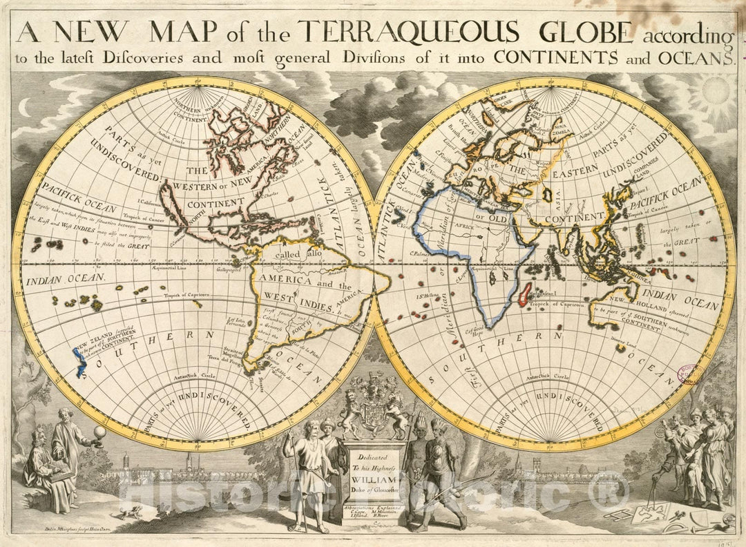
Historical Map, 1700-1799 A New map of The terraqueous Globe According to The Latest Discoveries and Most General divisions of it into Continents and Oceans, Vintage Wall Art
From:
$49.99
Historical Map, 1794 A New map of The United States of North America with The British dominions on That Continent et Cetera, Vintage Wall Art
From:
$49.99
Historical Map, 1755 Carte des possessions angloises & francoises du continent de l'Amerique septentrionale = Kaart van de Engelsche en Fransche bezittingen, Vintage Wall Art
From:
$49.99
Historical Map, 1715 A New and Exact map of The dominions of The King of Great Britain on ye Continent of North America : containing Newfoundland, New Scotalnd, Vintage Wall Art
From:
$49.99
Historical Map, 1768 The Island and Colony of Cayenne Subject to The French, on The Continent of South America, Vintage Wall Art
From:
$49.99
Historical Map, 1872 Colton's General map of The United States : Showing The Railroad Routes Across The Continent, Vintage Wall Art
From:
$49.99
Historical Map, 1840 Carte du Nouveau Continent : selon sa Plus Grande Longueur diametrale Depuis la Riviere de la Plata jusqu'au de la du Lac des Assiniboils, Vintage Wall Art
From:
$49.99
Historical Map, 1482 Decima Europe tabula continent Macedonia et Epirum et Achaiam & Peloponesum, Vintage Wall Art
From:
$49.99
Historical Map, 1915 National Highways map of The United States Showing Principal transcontinental Highways and Connecting System of one Hundred Thousand Miles, Vintage Wall Art
From:
$49.99
Historical Map, A New map of The Whole Continent of America, Divided into North and South and West Indies, Vintage Wall Art
From:
$29.99
Historical Map, 1911 The A.A.A. key road map of continental Europe, Vintage Wall Art
From:
$49.99
Historical Map, 1852 Index map to the handbook for travellers on the continent, Vintage Wall Art
From:
$34.99
Historic Map : The Indian Subcontinent, Stieler, 1873, Vintage Wall Art
From:
$49.99
Historic Map : Pictorial Map of New Orleans, Louisiana, Trans Continental, 1972, Vintage Wall Art
From:
$49.99
icon-chevron-left
Previous
1
…
20
21
22
icon-X
"Close (esc)"
icon-chevron-left
icon-X
icon-chevron
icon-X
Continent Wall Maps, Posters & Prints