icon

Free Shipping     |     Satisfaction Guaranteed

Illinois State Maps

Showing products 1 - 80 of 136
Sort by:

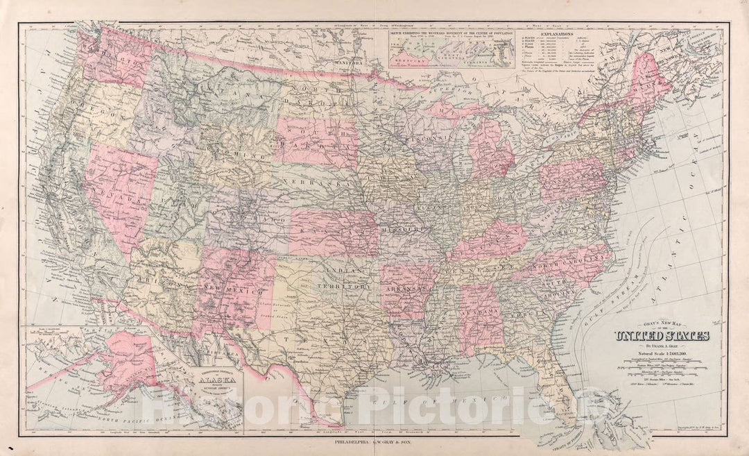
Historic Map : Department of The Interior General Land office Map - State of Illinois. 1878 - Vintage Wall Art

Department Of The Interior General Land Office J.A. Williamson, Commissioner. State of Illinois. 1878. Compiled from the official Records of the General Land Office and other sources by C. Roeser,...
From: $49.99

Historic Map : States of Illinois, Missouri and Arkansas, 1857, Vintage Wall Art

States of Illinois, Missouri and Arkansas, 1857We print high quality reproductions of historical maps, photographs, prints, etc. Because of their historical nature, some of these images may show signs of...
From: $49.99

Historic Map : United States Maps, Illinois 1894 , Vintage Wall Art

United States Maps, Illinois 1894
From: $49.99

Map : Wisconsin, Illinois, Iowa and Minnesota 1839, Magnetical chart, exhibiting the observations made by J. Locke during the survey of the mines of the United States

Magnetical chart, exhibiting the observations made by J. Locke during the survey of the mines of the United States / by David Dale Owen 1839We print high quality reproductions of...
From: $34.99

Map : Central United States from Illinois to Texas 1922, Map of the Lone Star Route : showing every city, town, village and hamlet throughout its entire length

Map of the Lone Star Route : showing every city, town, village and hamlet throughout its entire length / John C. Mulford, Chief cartographerWe print high quality reproductions of historical...
From: $34.99

Map : Seismicity map of the state of Illinois, 1979 Cartography Wall Art :

Seismicity map of the state of IllinoisWe print high quality reproductions of historical maps, photographs, prints, etc. Because of their historical nature, some of these images may show signs of...
From: $49.99

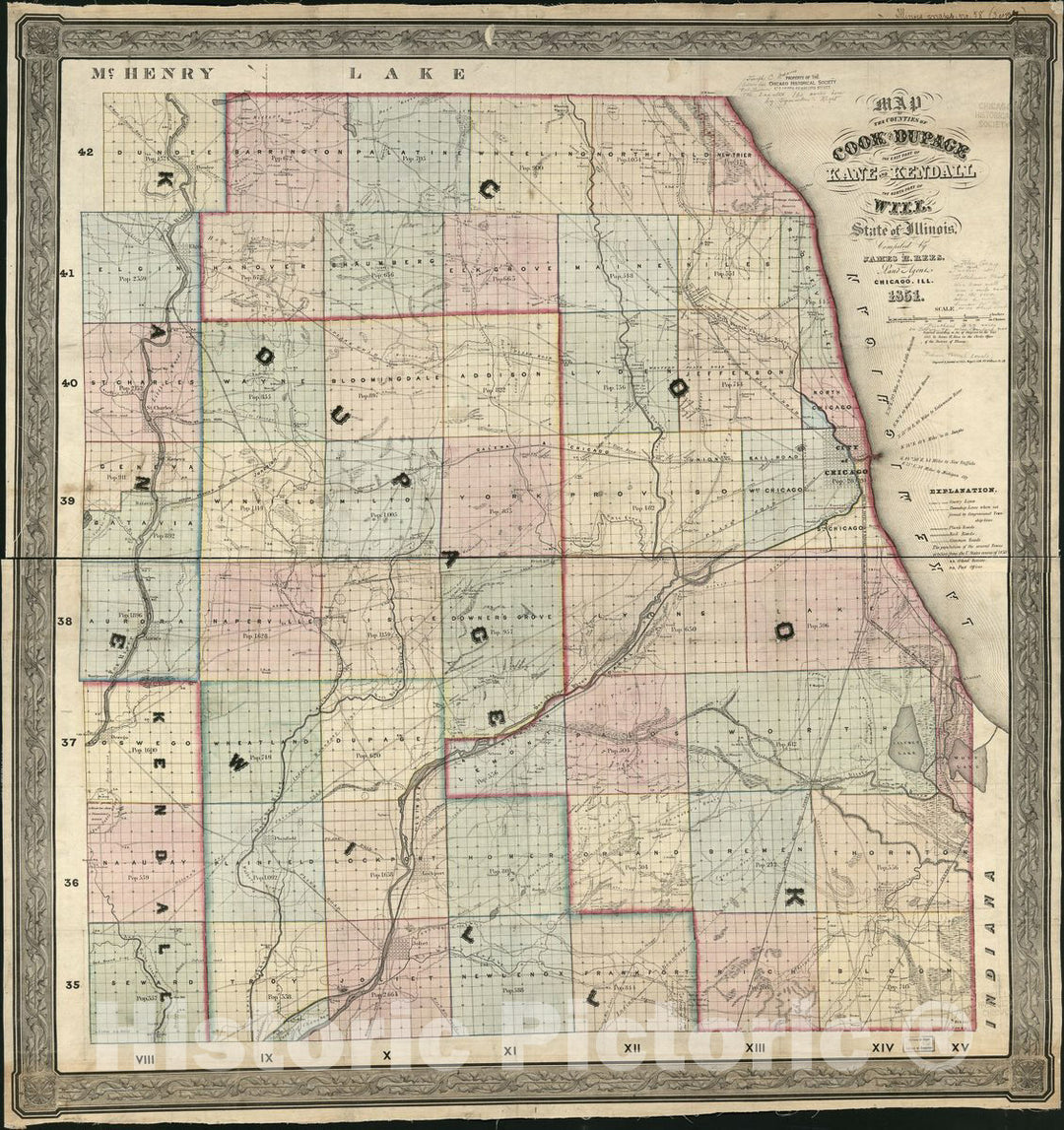
Historic 1851 Map - Map of The Counties of Cook and DuPage, The East Part of Kane and Kendall, The North Part of Will, State of Illinois

Map of the Counties of Cook and DuPage, the east part of Kane and Kendall, the north part of Will, state of IllinoisWe print high quality reproductions of historical maps,...
From: $34.99

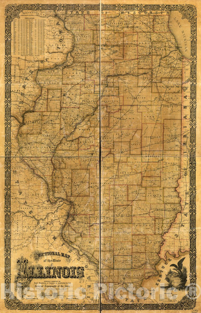
Historic 1861 Map - Sectional map of The State of Illinois : Especially exhibiting The Exact Boundaries of Counties as Established by Law and The General Topography of The State as Towns

Sectional map of the state of Illinois : especially exhibiting the exact boundaries of counties as established by law and the general topography of the state as towns, streams, lakes,...
From: $49.99

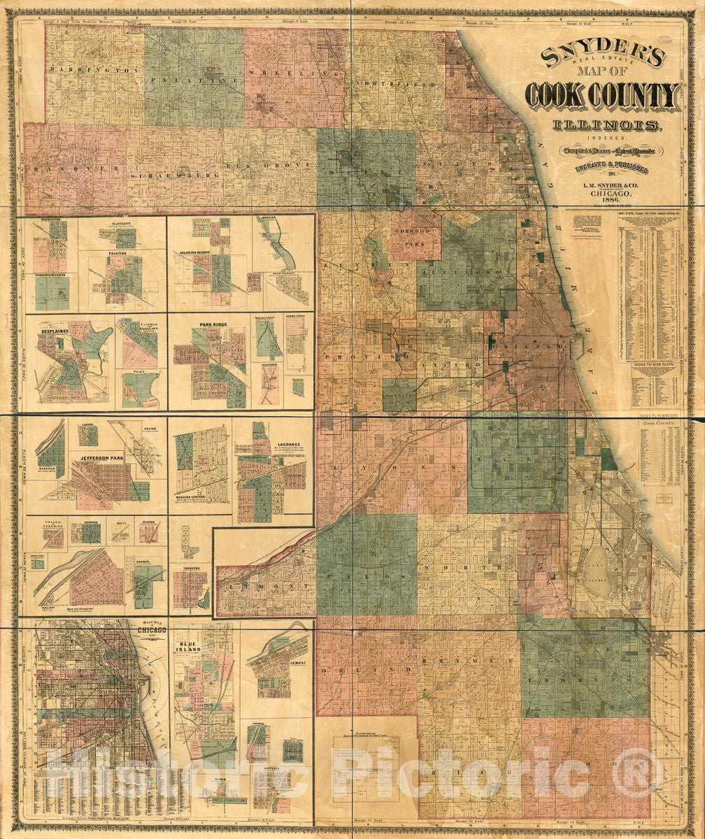
Historic 1886 Map - Snyder's Real Estate map of Cook County, Illinois : indexed

Snyder's real estate map of Cook County, Illinois : indexedWe print high quality reproductions of historical maps, photographs, prints, etc. Because of their historical nature, some of these images may...
From: $49.99

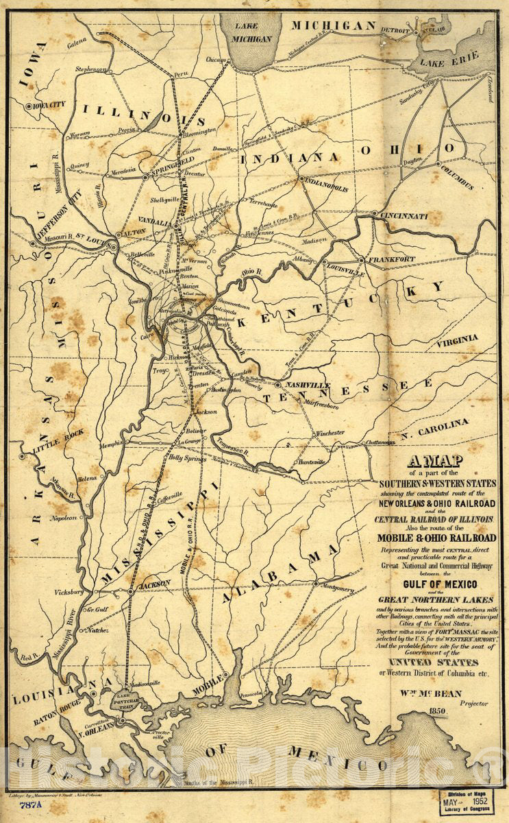
Historic 1850 Map - A map of a Part of The Southern & Western States Showing The contemplated Route of The New Orleans & Ohio Railroad and The Central Railroad of Illinois

A map of a part of the southern & western states showing the contemplated route of the New Orleans & Ohio Railroad and the Central Railroad of Illinois, also the...
From: $49.99

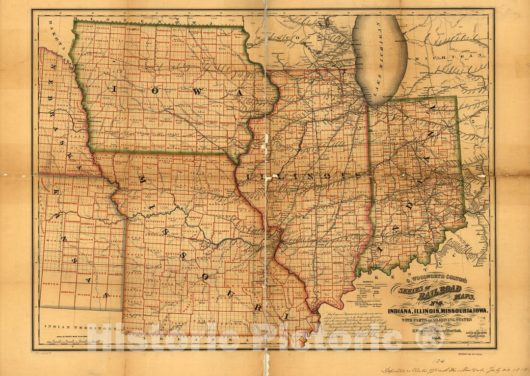
Historic 1858 Map - Indiana, Illinois, Missouri & Iowa with Parts of adjoining States.

Indiana, Illinois, Missouri & Iowa with parts of adjoining states.We print high quality reproductions of historical maps, photographs, prints, etc. Because of their historical nature, some of these images may...
From: $49.99

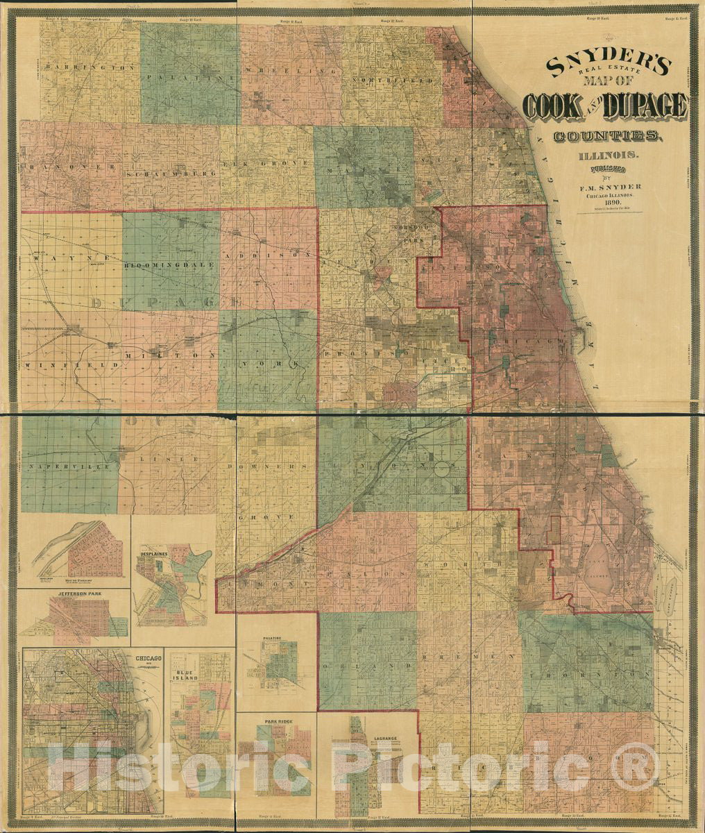
Historic 1890 Map - Snyder's Real Estate map of Cook and DuPage Counties, Illinois.

Snyder's real estate map of Cook and Dupage Counties, Illinois.We print high quality reproductions of historical maps, photographs, prints, etc. Because of their historical nature, some of these images may...
From: $49.99

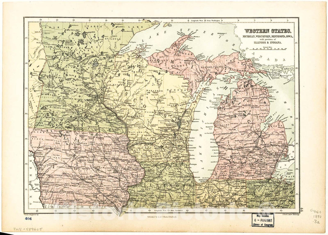
Historic 1873 Map - Western States, Michigan, Wisconsin, Minnesota, Iowa : with portions of Illinois & Indiana

Western states, Michigan, Wisconsin, Minnesota, Iowa : with portions of Illinois & IndianaWe print high quality reproductions of historical maps, photographs, prints, etc. Because of their historical nature, some of...
From: $49.99

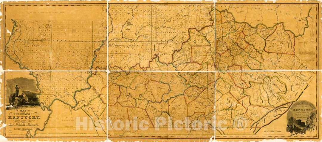
Historic 1818 Map - A map of The State of Kentucky : from Actual Survey ; Also Part of Indiana and Illinois

A map of the State of Kentucky : from actual survey ; also part of Indiana and IllinoisWe print high quality reproductions of historical maps, photographs, prints, etc. Because of...
From: $34.99

Historic 1891 Map - Plat Book of Mason County, Illinois - United States

Plat book of Mason County, IllinoisWe print high quality reproductions of historical maps, photographs, prints, etc. Because of their historical nature, some of these images may show signs of wear...
From: $49.99

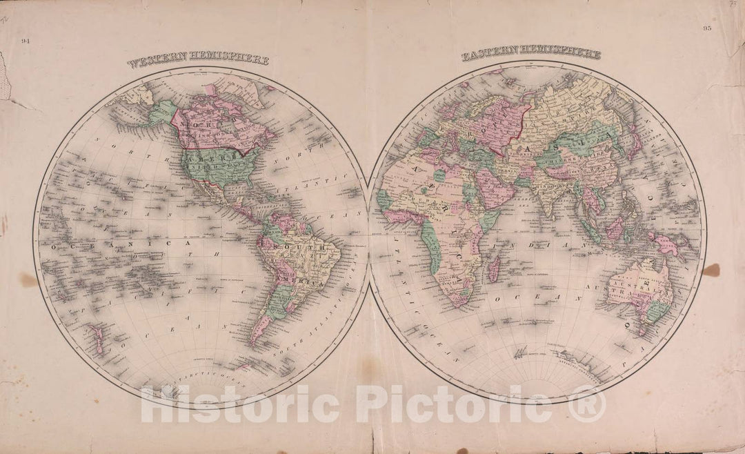
Historic 1870 Map - Atlas of Marshall Co. and The State of Illinois - Map of Western and Eastern Hemisphere - Atlas of Marshall County and The State of Illinois

Atlas of Marshall Co. and the state of Illinois : to which is added an atlas of the United States, maps of the hemispheres &c. &c. &c.We print high quality...
From: $49.99

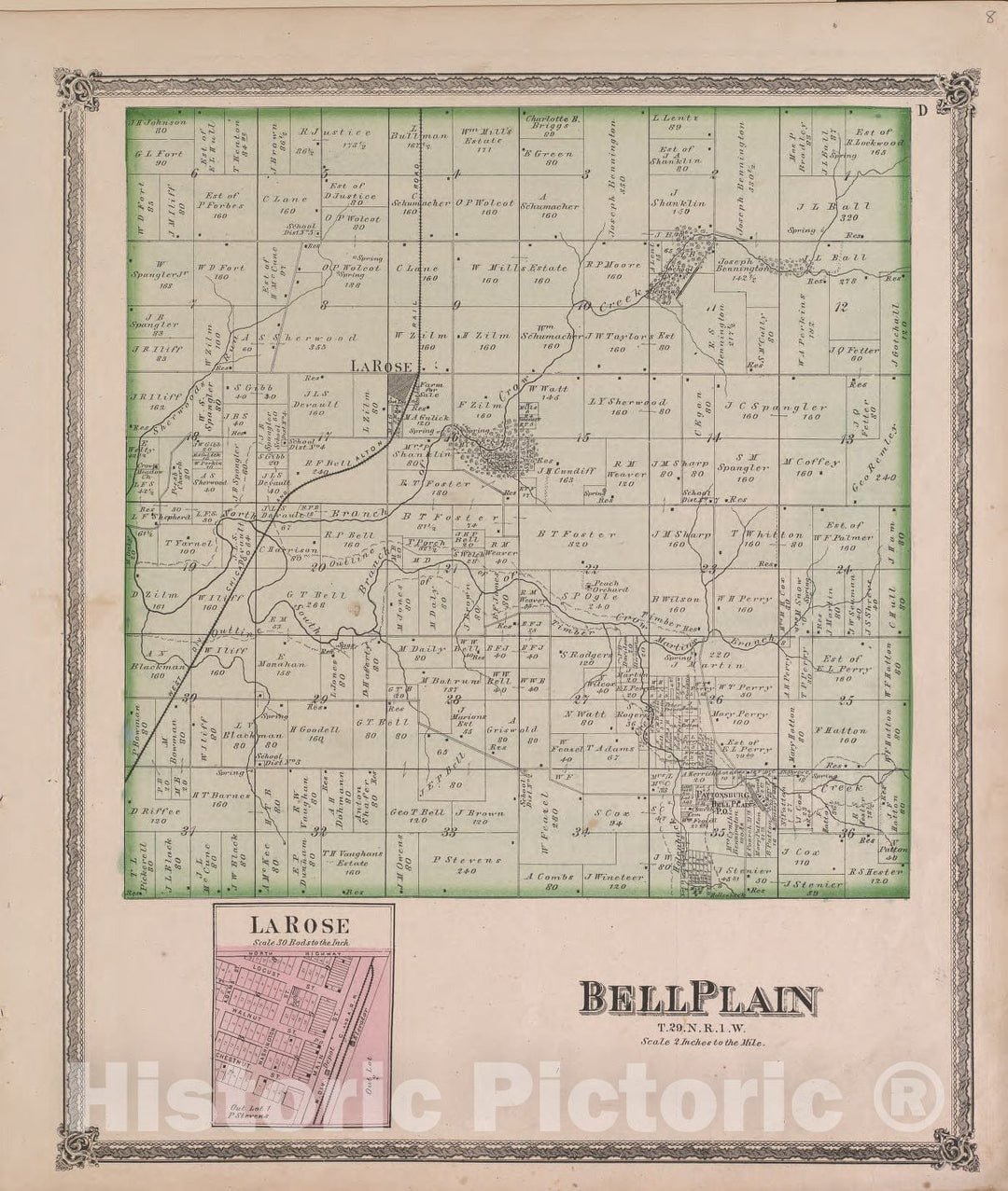
Historic 1870 Map - Atlas of Marshall Co. and The State of Illinois - BellPlain - Atlas of Marshall County and The State of Illinois

Atlas of Marshall Co. and the state of Illinois : to which is added an atlas of the United States, maps of the hemispheres &c. &c. &c.We print high quality...
From: $49.99

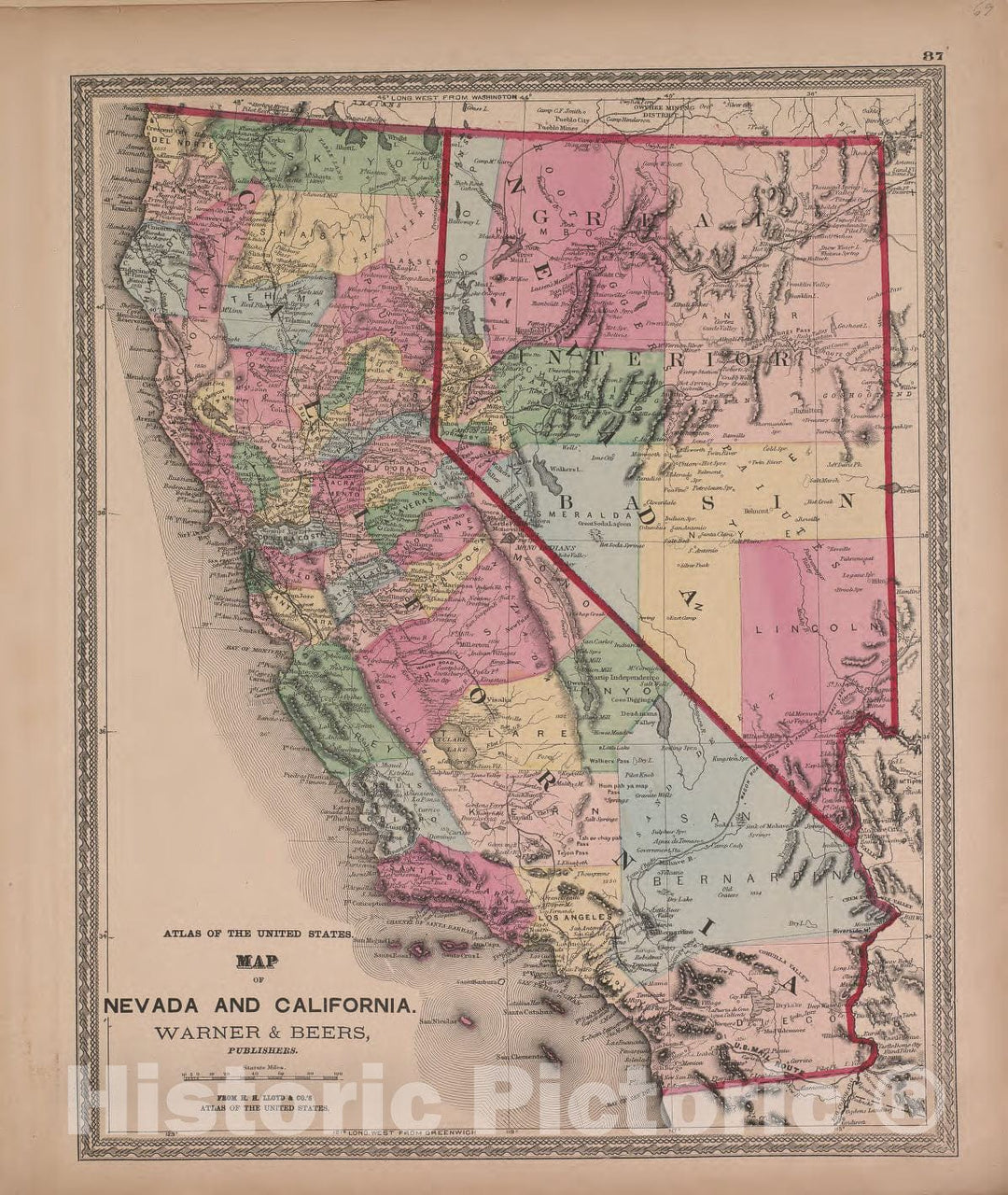
Historic 1870 Map - Atlas of Marshall Co. and The State of Illinois - Map of Nevada and California - Atlas of Marshall County and The State of Illinois

Atlas of Marshall Co. and the state of Illinois : to which is added an atlas of the United States, maps of the hemispheres &c. &c. &c.We print high quality...
From: $49.99

Historic 1870 Map - Atlas of Marshall Co. and The State of Illinois - Steuben - Atlas of Marshall County and The State of Illinois

Atlas of Marshall Co. and the state of Illinois : to which is added an atlas of the United States, maps of the hemispheres &c. &c. &c.We print high quality...
From: $49.99

Historic 1870 Map - Atlas of Marshall Co. and The State of Illinois - Map of Texas - Atlas of Marshall County and The State of Illinois

Atlas of Marshall Co. and the state of Illinois : to which is added an atlas of the United States, maps of the hemispheres &c. &c. &c.We print high quality...
From: $49.99

Historic 1870 Map - Atlas of Marshall Co. and The State of Illinois - Map of Montana, Idaho, and Wyoming, Warner and Beers - Atlas of Marshall County and The State of Illinois

Atlas of Marshall Co. and the state of Illinois : to which is added an atlas of the United States, maps of the hemispheres &c. &c. &c.We print high quality...
From: $49.99

Historic 1870 Map - Atlas of Marshall Co. and The State of Illinois - Map of Washington and Oregon - Atlas of Marshall County and The State of Illinois

Atlas of Marshall Co. and the state of Illinois : to which is added an atlas of the United States, maps of the hemispheres &c. &c. &c.We print high quality...
From: $49.99

Historic 1870 Map - Atlas of Marshall Co. and The State of Illinois - Saratoga - Atlas of Marshall County and The State of Illinois

Atlas of Marshall Co. and the state of Illinois : to which is added an atlas of the United States, maps of the hemispheres &c. &c. &c.We print high quality...
From: $49.99

Historic 1893 Map - Plat Book of McDonough County, Illinois - Map of The United States

Plat book of McDonough County, IllinoisWe print high quality reproductions of historical maps, photographs, prints, etc. Because of their historical nature, some of these images may show signs of wear...
From: $49.99

Historic 1870 Map - Atlas of Marshall Co. and The State of Illinois - Henry - Atlas of Marshall County and The State of Illinois

Atlas of Marshall Co. and the state of Illinois : to which is added an atlas of the United States, maps of the hemispheres &c. &c. &c.We print high quality...
From: $49.99

Historic 1870 Map - Atlas of Marshall Co. and The State of Illinois - Map of The City of Chicago - Atlas of Marshall County and The State of Illinois

Atlas of Marshall Co. and the state of Illinois : to which is added an atlas of the United States, maps of the hemispheres &c. &c. &c.We print high quality...
From: $49.99

Historic 1870 Map - Atlas of Marshall Co. and The State of Illinois - La Prairie - Atlas of Marshall County and The State of Illinois

Atlas of Marshall Co. and the state of Illinois : to which is added an atlas of the United States, maps of the hemispheres &c. &c. &c.We print high quality...
From: $49.99

Historic 1870 Map - Atlas of Marshall Co. and The State of Illinois - Map of West Indies - Atlas of Marshall County and The State of Illinois

Atlas of Marshall Co. and the state of Illinois : to which is added an atlas of the United States, maps of the hemispheres &c. &c. &c.We print high quality...
From: $49.99

Historic 1870 Map - Atlas of Marshall Co. and The State of Illinois - Richland - Atlas of Marshall County and The State of Illinois

Atlas of Marshall Co. and the state of Illinois : to which is added an atlas of the United States, maps of the hemispheres &c. &c. &c.We print high quality...
From: $49.99

Historic 1870 Map - Atlas of Marshall Co. and The State of Illinois - Evans - Atlas of Marshall County and The State of Illinois

Atlas of Marshall Co. and the state of Illinois : to which is added an atlas of the United States, maps of the hemispheres &c. &c. &c.We print high quality...
From: $49.99

Historic 1870 Map - Atlas of Marshall Co. and The State of Illinois - Map of The Southern States - Atlas of Marshall County and The State of Illinois

Atlas of Marshall Co. and the state of Illinois : to which is added an atlas of the United States, maps of the hemispheres &c. &c. &c.We print high quality...
From: $49.99

Historic 1870 Map - Atlas of Marshall Co. and The State of Illinois - Wenona and Sparland - Atlas of Marshall County and The State of Illinois

Atlas of Marshall Co. and the state of Illinois : to which is added an atlas of the United States, maps of the hemispheres &c. &c. &c.We print high quality...
From: $49.99

Historic 1870 Map - Atlas of Marshall Co. and The State of Illinois - Official Railroad map of Illinois - Atlas of Marshall County and The State of Illinois

Atlas of Marshall Co. and the state of Illinois : to which is added an atlas of the United States, maps of the hemispheres &c. &c. &c.We print high quality...
From: $49.99

Historic 1870 Map - Atlas of Marshall Co. and The State of Illinois - Lacon - Atlas of Marshall County and The State of Illinois

Atlas of Marshall Co. and the state of Illinois : to which is added an atlas of the United States, maps of the hemispheres &c. &c. &c.We print high quality...
From: $49.99

Historic 1870 Map - Atlas of Marshall Co. and The State of Illinois - Hopewell - Atlas of Marshall County and The State of Illinois

Atlas of Marshall Co. and the state of Illinois : to which is added an atlas of the United States, maps of the hemispheres &c. &c. &c.We print high quality...
From: $49.99

Historic 1870 Map - Atlas of Marshall Co. and The State of Illinois - New England, New York and New Jersey - Atlas of Marshall County and The State of Illinois

Atlas of Marshall Co. and the state of Illinois : to which is added an atlas of the United States, maps of the hemispheres &c. &c. &c.We print high quality...
From: $49.99

Historic 1870 Map - Atlas of Marshall Co. and The State of Illinois - Bennington - Atlas of Marshall County and The State of Illinois

Atlas of Marshall Co. and the state of Illinois : to which is added an atlas of the United States, maps of the hemispheres &c. &c. &c.We print high quality...
From: $49.99

Historic 1870 Map - Atlas of Marshall Co. and The State of Illinois - Map of The Central States, Warner and Beers - Atlas of Marshall County and The State of Illinois

Atlas of Marshall Co. and the state of Illinois : to which is added an atlas of the United States, maps of the hemispheres &c. &c. &c.We print high quality...
From: $49.99

Historic 1870 Map - Atlas of Marshall Co. and The State of Illinois - Political map of Illinois - Atlas of Marshall County and The State of Illinois

Atlas of Marshall Co. and the state of Illinois : to which is added an atlas of the United States, maps of the hemispheres &c. &c. &c.We print high quality...
From: $34.99

Historic 1870 Map - Atlas of Marshall Co. and The State of Illinois - Map of Dakota, Minnesota and Nebraska - Atlas of Marshall County and The State of Illinois

Atlas of Marshall Co. and the state of Illinois : to which is added an atlas of the United States, maps of the hemispheres &c. &c. &c.We print high quality...
From: $49.99

Historic 1870 Map - Atlas of Marshall Co. and The State of Illinois - Whitefield - Atlas of Marshall County and The State of Illinois

Atlas of Marshall Co. and the state of Illinois : to which is added an atlas of the United States, maps of the hemispheres &c. &c. &c.We print high quality...
From: $49.99

Historic 1870 Map - Atlas of Marshall Co. and The State of Illinois - Atlas of Illinois - Atlas of Marshall County and The State of Illinois

Atlas of Marshall Co. and the state of Illinois : to which is added an atlas of the United States, maps of the hemispheres &c. &c. &c.We print high quality...
From: $49.99

Historic 1870 Map - Atlas of Marshall Co. and The State of Illinois - Roberts - Atlas of Marshall County and The State of Illinois

Atlas of Marshall Co. and the state of Illinois : to which is added an atlas of the United States, maps of the hemispheres &c. &c. &c.We print high quality...
From: $49.99

Historic 1870 Map - Atlas of Marshall Co. and The State of Illinois - Atlas of Illinois-Continued - Atlas of Marshall County and The State of Illinois 1

Atlas of Marshall Co. and the state of Illinois : to which is added an atlas of the United States, maps of the hemispheres &c. &c. &c.We print high quality...
From: $49.99

Historic 1870 Map - Atlas of Marshall Co. and The State of Illinois - Map of Utah, Arizona, New Mexico, Knasas, Colorado - Atlas of Marshall County and The State of Illinois

Atlas of Marshall Co. and the state of Illinois : to which is added an atlas of the United States, maps of the hemispheres &c. &c. &c.We print high quality...
From: $49.99

Historic 1891 Map - Plat Book of Mason County, Illinois - Analysis of The System of United States Land surveys - 1

Plat book of Mason County, IllinoisWe print high quality reproductions of historical maps, photographs, prints, etc. Because of their historical nature, some of these images may show signs of wear...
From: $49.99

Historic 1870 Map - Atlas of Kendall Co. and The State of Illinois - Counties of Jo Daviess, Stephenson, Carroll and Rock Island

Atlas of Kendall Co. and the state of Illinois : to which is added an atlas of the United States, maps of the hemispheres &c. &c. &c.We print high quality...
From: $49.99

Historic 1870 Map - Atlas of Kendall Co. and The State of Illinois - Counties of Putnam, Stark, Marshall, Peoria, Woodford and Tazewell

Atlas of Kendall Co. and the state of Illinois : to which is added an atlas of the United States, maps of the hemispheres &c. &c. &c.We print high quality...
From: $49.99

Historic 1870 Map - Atlas of Kendall Co. and The State of Illinois - Utah, Arizona, New Mexico, Kansas, Colorado & Indian Territory

Atlas of Kendall Co. and the state of Illinois : to which is added an atlas of the United States, maps of the hemispheres &c. &c. &c.We print high quality...
From: $49.99

Historic 1870 Map - Atlas of Kendall Co. and The State of Illinois - Lisbon; View of Court House, Yorkville; Practical Description of Lands

Atlas of Kendall Co. and the state of Illinois : to which is added an atlas of the United States, maps of the hemispheres &c. &c. &c.We print high quality...
From: $49.99

Historic 1870 Map - Atlas of Kendall Co. and The State of Illinois : - Hancock, Brown and Adams; Pike, Scott, Morgan, Greene, Jersey and Calhoun

Atlas of Kendall Co. and the state of Illinois : to which is added an atlas of the United States, maps of the hemispheres &c. &c. &c.We print high quality...
From: $49.99

Historic 1906 Map - Standard Atlas of Madison County, Illinois : Including a plat Book of The Villages, Cities and townships of The County, map of The State - World

Standard atlas of Madison County, Illinois : including a plat book of the villages, cities and townships of the county, map of the state, United States and world : patrons...
From: $49.99

Historic 1903 Map - Standard Atlas of Kendall County, Illinois : Including a plat Book of The Villages, Cities and townships of The County, map of The State - The World

Standard atlas of Kendall County, Illinois : including a plat book of the villages, cities and townships of the county, map of the state, United States and world : patrons...
From: $49.99

Historic 1929 Map - Standard Atlas of Tazewell County, Illinois : Including a plat Book of The Villages, Cities and townships of The County, map of The State - Fon du Lac

Standard atlas of Tazewell County, Illinois : including a plat book of the villages, cities and townships of the county, map of the state, United States and world : patrons...
From: $49.99

Historic 1870 Map - Atlas of Kendall Co. and The State of Illinois : to which is Added an Atlas of The United States - Piatt, Champaign & Vermillion

Atlas of Kendall Co. and the state of Illinois : to which is added an atlas of the United States, maps of the hemispheres &c. &c. &c.We print high quality...
From: $49.99

Historic 1907 Map - Standard Atlas of Stark County, Illinois - Map of The United States

Standard atlas of Stark County, Illinois : including a plat book of the villages, cities and townships of the county, map of the state, United States and world : patrons...
From: $49.99

Historic 1893 Map - Plat Book of Woodford County, Illinois - Analysis of The System of United States Land Surveys

Plat book of Woodford County, IllinoisWe print high quality reproductions of historical maps, photographs, prints, etc. Because of their historical nature, some of these images may show signs of wear...
From: $49.99

Historic 1891 Map - Plat Book of Tazewell County, Illinois - Gray's New Map of The United States

Plat book of Tazewell County, IllinoisWe print high quality reproductions of historical maps, photographs, prints, etc. Because of their historical nature, some of these images may show signs of wear...
From: $49.99

Historic 1895 Map - Plat Book of Pike County, Illinois - Analysis of The System of United States Land Surveys - Standard Atlas of Pike County, Illinois

Plat book of Pike County, IllinoisWe print high quality reproductions of historical maps, photographs, prints, etc. Because of their historical nature, some of these images may show signs of wear...
From: $34.99

Historic 1894 Map - Plat Book of De WITT County, Illinois - Gray's New Map of The United States

Plat book of De Witt County, IllinoisWe print high quality reproductions of historical maps, photographs, prints, etc. Because of their historical nature, some of these images may show signs of...
From: $49.99

Historic 1893 Map - Plat Book of Woodford County, Illinois - Gray's New Map of United States

Plat book of Woodford County, IllinoisWe print high quality reproductions of historical maps, photographs, prints, etc. Because of their historical nature, some of these images may show signs of wear...
From: $49.99

Historic 1893 Map - Plat Book of Douglas Co, Illinois - Gray's New Map of The United States - Plat Book of Douglas County, Illinois

Plat book of Douglas Co., IllinoisWe print high quality reproductions of historical maps, photographs, prints, etc. Because of their historical nature, some of these images may show signs of wear...
From: $49.99

Historic 1895 Map - Plat Book of Pike County, Illinois - Gray's New Map of The United States - Standard Atlas of Pike County, Illinois

Plat book of Pike County, IllinoisWe print high quality reproductions of historical maps, photographs, prints, etc. Because of their historical nature, some of these images may show signs of wear...
From: $49.99

Historic 1894 Map - Plat Book of De WITT County, Illinois - Analysis of The System of United States Land Surveys

Plat book of De Witt County, IllinoisWe print high quality reproductions of historical maps, photographs, prints, etc. Because of their historical nature, some of these images may show signs of...
From: $49.99

Historic 1893 Map - Plat Book of Henry County, Illinois - Analysis of The System of United States Land Surveys

Plat book of Henry County, IllinoisWe print high quality reproductions of historical maps, photographs, prints, etc. Because of their historical nature, some of these images may show signs of wear...
From: $34.99

Historic 1891 Map - Plat Book of Tazewell County, Illinois - Analysis of The System of United States Land Surveys

Plat book of Tazewell County, IllinoisWe print high quality reproductions of historical maps, photographs, prints, etc. Because of their historical nature, some of these images may show signs of wear...
From: $49.99

Historic 1893 Map - Plat Book of Henry County, Illinois - Gray's New Map of The United States

Plat book of Henry County, IllinoisWe print high quality reproductions of historical maps, photographs, prints, etc. Because of their historical nature, some of these images may show signs of wear...
From: $49.99

Historic 1893 Map - Plat Book of Douglas Co, Illinois - Analysis of The System, United States Land Surveys - Plat Book of Douglas County, Illinois

Plat book of Douglas Co., IllinoisWe print high quality reproductions of historical maps, photographs, prints, etc. Because of their historical nature, some of these images may show signs of wear...
From: $49.99

Historic 1901 Map - Standard Atlas of Monroe County, Illinois : Including a plat Book of The Villages, Cities and townships of The County, map of The State - United States

Standard atlas of Monroe County, Illinois : including a plat book of the villages, cities and townships of the county, map of the state, United States and world, patrons directory,...
From: $49.99

Historic Map : 1818 Map of Part of the United Stated of North America with the Territory of Illinois on the Ohio : Vintage Wall Art

Vintage Map | 1818 Map of Part of the United Stated of North America with the Territory of Illinois on the Ohio Particularly Designed to Illustrate Birkbeck's Journey | Taylor,...
From: $49.99

Historic Map : 1867 County Map of the State of Illinois : Vintage Wall Art

Vintage Map | 1867 County Map of the State of Illinois | Mitchell, Samuel Augustus
From: $49.99

Historic Map : 1861 County Map of the State of Illinois : Vintage Wall Art

Vintage Map | 1861 County Map of the State of Illinois | Mitchell, Samuel Augustus Jr.
From: $49.99

Historic Map : 1858 A New Map of the State of Illinois : Vintage Wall Art

Vintage Map | 1858 A New Map of the State of Illinois | Thomas, Cowperthwait and Company
From: $49.99

Historic Map : 1856 A New Map of the State of Illinois : Vintage Wall Art

Vintage Map | 1856 A New Map of the State of Illinois | Desilver, Charles
From: $49.99

Historic Map : 1851 Map of the State of Illinois : Vintage Wall Art

Vintage Map | 1851 Map of the State of Illinois | Thomas, Cowperthwait and Company
From: $49.99

Historic Map : 1850 Map of the State of Illinois : Vintage Wall Art

Vintage Map | 1850 Map of the State of Illinois | Thomas, Cowperthwait & Co.
From: $49.99

Historic Map : 1850 A New Map of the State of Illinois : Vintage Wall Art

Vintage Map | 1850 A New Map of the State of Illinois | Thomas, Cowperthwait and Company
From: $49.99

Historic Map : 1845 Diagram of the State of Illinois : Vintage Wall Art

Vintage Map | 1845 Diagram of the State of Illinois | Conway, F.R.
From: $49.99

Historic Map : 1840 Diagram of the State of Illinois : Vintage Wall Art

Vintage Map | 1840 Diagram of the State of Illinois | Milburn, William, Surveyor Geneal
From: $49.99
Showing products 1 - 80 of 136

Free Shipping

We offer Free Standard Shipping for all orders within the United States. If you want your stuff there faster, see Expedited and Overnight shipping cost at checkout.

Our Guarantee

If you are not completely satisfied, just send the product back to us and we'll replace it with another one of your choice OR refund your purchase price 100%. Our address is on the contact us page.

100% Satisfaction

We painstakingly labor over the preparation and printing of each individual product we sell. We stand behind the materials and workmanship, and want nothing more than for you to be 100% happy with your order.

Just added to your wishlist:
My Wishlist
Just added to your cart:
My Cart