Skip to content
icon-X
Close menu
Maps
World Maps
World War 2 Maps
Pictorial Maps
USGS TopoGraphic Maps
Art Prints
Blueprints
Fine Art Museum Collections
Claude Monet
Photographs
Modern Photos
Posters
Collections
Kid's Room
Autos, Trains & Rails
Monet and Manet
Brewery, Beer, Liquor & more
Holiday Ready to Gift Products
Log in
Follow Us
instagram
Instagram
Facebook
twitter
Twitter
Maps
World Maps
World War 2 Maps
Pictorial Maps
USGS TopoGraphic Maps
Art Prints
Blueprints
Fine Art Museum Collections
Claude Monet
Photographs
Modern Photos
Posters
Collections
Kid's Room
Autos, Trains & Rails
Monet and Manet
Brewery, Beer, Liquor & more
Holiday Ready to Gift Products
account
Log in
icon-search
Search
icon-hamburger
Site navigation
icon-bag-minimal
Cart
Search
Search
Free economy shipping for unframed orders of $75 or more!
Filter
icon-X
Close menu
Product type
Geologic Map
(1)
Map
(194)
Topographic Map
(2)
Availability
In stock
(197)
Out of stock
(0)
Price
Iowa State Maps
icon-filter
Filter
Historic Map : 1875 Map of Carroll County, State of Iowa. - Vintage Wall Art
From:
$49.99
Historic Map : 1875 Plans of Brooklyn, Grinnell, Montezuma and Malcolm, State of Iowa. - Vintage Wall Art
From:
$49.99
Historic Map : Iowa the Hawk-eye State 1939 - Vintage Wall Art
From:
$49.99
Historic Map : 1875 Map of Mitchell County, State of Iowa. - Vintage Wall Art
From:
$49.99
Historic Map : Department of The Interior General Land office Map - State of Iowa. 1878 - Vintage Wall Art
From:
$49.99
Historic Map : A New Map of the State of Iowa : Published by Charles Desilver, 1859 - Vintage Wall Art
From:
$49.99
Historic Map : 1875 Plans of Atlantic, Osceola, Lewis, Hopeville and Murray, State of Iowa. - Vintage Wall Art
From:
$49.99
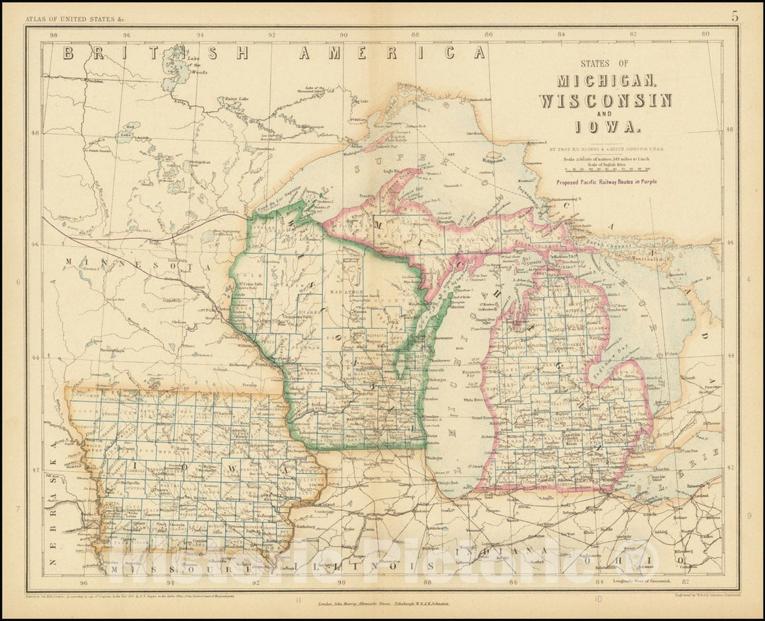
Historic Map : States of Michigan, Wisconsin, and Iowa, 1857, Vintage Wall Art
From:
$49.99
Historic Map : Chapman's Sectional State of IowaCompiled from the United States Surveys and other authentic Sources Published by Dyer & Pasmore, 1857, 1857, Vintage Wall Art
From:
$49.99
Historic Map : Railway Iowa Prepared and Printed For The Secretary of State By Order of the Twenty-Fourth General Assembly.1892, 1892, Vintage Wall Art
From:
$49.99
Historic Map : United States Maps, Iowa 1894 , Vintage Wall Art
From:
$39.99
Historic 1842-[1845] Map - Iowa. - United States - Iowa-Atlases Of The United States - Vintage Wall Art
From:
$49.99
Map : Iowa 1939, Iowa : the hawk-eye state , Antique Vintage Reproduction
From:
$49.99
Map : Iowa 1916, National highways preliminary map of the state of Iowa : showing thirty-eight hundred miles of national highways, Antique Vintage Reproduction
From:
$29.99
Map : Iowa 1919, National highways map of the state of Iowa : showing twenty-eight hundred miles of national highways
From:
$29.99
Map : Wisconsin, Illinois, Iowa and Minnesota 1839, Magnetical chart, exhibiting the observations made by J. Locke during the survey of the mines of the United States
From:
$34.99
Map : Compilation of records of surface waters of the United States, October 1950 to September 1960, part 6-B. Missouri River basin below Sioux City, Iowa, 1964 Cartography Wall Art :
From:
$39.99
Historic 1863 Map - Map of Cedar County, State of Iowa
From:
$49.99
Historic 1850 Map - Sectional map of The State of Iowa, compiled from The United States surveys Also exhibiting The Internal improvements, Distances Between Towns & Villages
From:
$49.99
1
2
3
…
11
icon-chevron
Next
icon-X
"Close (esc)"
icon-chevron-left
icon-X
icon-chevron
icon-X
Iowa State Maps, Posters & Prints


![Historic 1842-[1845] Map - Iowa. - United States - Iowa-Atlases Of The United States - Vintage Wall Art](http://www.historicpictoric.com/cdn/shop/products/5123940_1wmark.jpg?v=1599519285&width=1080)


