Skip to content
icon-X
Close menu
Maps
World Maps
World War 2 Maps
Pictorial Maps
USGS TopoGraphic Maps
Art Prints
Blueprints
Fine Art Museum Collections
Claude Monet
Photographs
Modern Photos
Posters
Collections
Kid's Room
Autos, Trains & Rails
Monet and Manet
Brewery, Beer, Liquor & more
Holiday Ready to Gift Products
Log in
Follow Us
instagram
Instagram
Facebook
twitter
Twitter
Maps
World Maps
World War 2 Maps
Pictorial Maps
USGS TopoGraphic Maps
Art Prints
Blueprints
Fine Art Museum Collections
Claude Monet
Photographs
Modern Photos
Posters
Collections
Kid's Room
Autos, Trains & Rails
Monet and Manet
Brewery, Beer, Liquor & more
Holiday Ready to Gift Products
account
Log in
icon-search
Search
icon-hamburger
Site navigation
icon-bag-minimal
Cart
Search
Search
Free economy shipping for unframed orders of $75 or more!
Filter
icon-X
Close menu
Lake Maps
icon-filter
Filter
Historic Nautical Map - Sabine Pass And Lake, 1994 NOAA Chart - Texas, Louisiana (TX, LA) - Vintage Wall Art
From:
$39.99
Historic Nautical Map - Isle Royale Michigan Lake Superior, 1951 NOAA Chart - Michigan (MI) - Vintage Wall Art
From:
$49.99
Historic Nautical Map - Isle Royale Michigan Lake Superior, 1948 NOAA Chart - Michigan (MI) - Vintage Wall Art
From:
$49.99
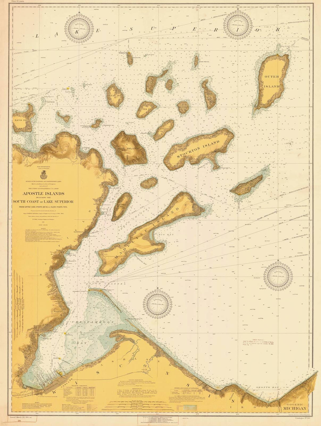
Historic Nautical Map - Apostle Islands Including The South Coast Of Lake Superior, 1918 NOAA Chart - Wisconsin (WI) - Vintage Wall Art
From:
$59.99
Historic Nautical Map - Apostle Islands Including The South Coast Of Lake Superior, 1946 NOAA Chart - Wisconsin (WI) - Vintage Wall Art
From:
$49.99
Historic Nautical Map - Keweenaw Waterway Mchigan Including Torch Lake, 1940 NOAA Chart - Michigan (MI) - Vintage Wall Art
From:
$49.99
Historic Nautical Map - Portage Lake And River Lake Superior Including Torch Lake Michigan, 1912 NOAA Chart - Michigan (MI) - Vintage Wall Art
From:
$49.99
Historic Nautical Map - Keweenaw Bay Including Lanse And Portage Entry Lake Superior, 1924 NOAA Chart - Michigan (MI) - Vintage Wall Art
From:
$49.99
Historic Nautical Map - Huron Bay And Huron Islands Lake Superior, 1915 NOAA Chart - Michigan (MI) - Vintage Wall Art
From:
$49.99
Historic Nautical Map - West Bay To Cedar Lakes Including Freeport Harbor, 1966 NOAA Chart - Texas (TX) - Vintage Wall Art
From:
$49.99
Historic Nautical Map - Apalachicola Bay To Lake Wimico, 1968 NOAA Chart - Florida (FL) - Vintage Wall Art
From:
$49.99
Historic Nautical Map - Lake Of The Woods, 1919 NOAA Chart - Minnesota (MN) - Vintage Wall Art
From:
$49.99
Historic Nautical Map - Rainy Lake, 1952 NOAA Chart - Minnesota (MN) - Vintage Wall Art
From:
$49.99
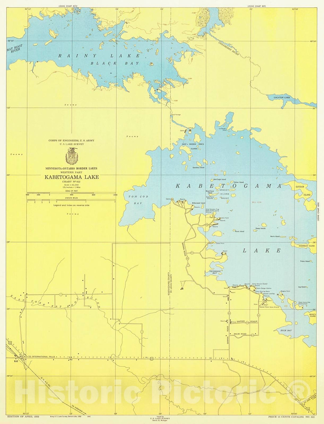
Historic Nautical Map - Minnesota-Ontario Border Lakes Western Part Kabetogama Lake, 1950 NOAA Chart - Minnesota (MN) - Vintage Wall Art
From:
$49.99
Historic Nautical Map - Rainy Lake International Falls To Dryweed Island, 1965 NOAA Chart - Minnesota (MN) - Vintage Wall Art
From:
$49.99
Historic Nautical Map - Rainy Lake, 1945 NOAA Chart - Minnesota (MN) - Vintage Wall Art
From:
$49.99
Historic Nautical Map - Rainy Lake, 1938 NOAA Chart - Minnesota (MN) - Vintage Wall Art
From:
$49.99
Historic Nautical Map - Rainy Lake, 1952 NOAA Chart - Minnesota (MN) - Vintage Wall Art, v2
From:
$49.99
Historic Nautical Map - Rainy Lake, 1949 NOAA Chart - Minnesota (MN) - Vintage Wall Art
From:
$49.99
icon-chevron-left
Previous
1
…
13
14
15
16
17
…
395
icon-chevron
Next
icon-X
"Close (esc)"
icon-chevron-left
icon-X
icon-chevron
icon-X
Lake Maps, Posters & Prints