Skip to content
icon-X
Close menu
Maps
World Maps
World War 2 Maps
Pictorial Maps
USGS TopoGraphic Maps
Art Prints
Blueprints
Fine Art Museum Collections
Claude Monet
Photographs
Modern Photos
Posters
Collections
Kid's Room
Autos, Trains & Rails
Monet and Manet
Brewery, Beer, Liquor & more
Holiday Ready to Gift Products
Log in
Follow Us
instagram
Instagram
Facebook
twitter
Twitter
Maps
World Maps
World War 2 Maps
Pictorial Maps
USGS TopoGraphic Maps
Art Prints
Blueprints
Fine Art Museum Collections
Claude Monet
Photographs
Modern Photos
Posters
Collections
Kid's Room
Autos, Trains & Rails
Monet and Manet
Brewery, Beer, Liquor & more
Holiday Ready to Gift Products
account
Log in
icon-search
Search
icon-hamburger
Site navigation
icon-bag-minimal
Cart
Search
Search
Free economy shipping for unframed orders of $75 or more!
Filter
icon-X
Close menu
Lake Maps
icon-filter
Filter
Historic Nautical Map - Lake Michigan Coast Farnsworth Pt To Fifteen Miles Southwest Of Escanaba Including Big Bay De Noc And Little Bay, 1957 NOAA Chart - Michigan (MI) - Poster Wall Art Reprint - 0
From:
$49.99
Historic Nautical Map - Lake Michigan Coast Green Bay From Point Detour To Baileys Harbor And Menominee, 1957 NOAA Chart - Wisconsin, Michigan (WI, MI) - Vintage Decor Poster Wall Art Reproduction - 0
From:
$49.99
Historic Nautical Map - Lake Michigan Coast Farnsworth Pt To Fifteen Miles Southwest Of Escanaba Including Big Bay De Noc And Little Bay, 1960 NOAA Chart - (MI Vintage) - Poster Wall Art Reprint - 0
From:
$49.99
Historic Nautical Map - Lake Dexter To Lake Harvey, 1972 NOAA Chart - Florida (FL) - Vintage Wall Art
From:
$34.99
Historic Nautical Map - Lake Dexter To Lake Harvey, 1972 NOAA Chart - Florida (FL) - Vintage Wall Art, v2
From:
$34.99
Historic Nautical Map - Racy Point To Crescent Lake, 1970 NOAA Chart - Florida (FL) - Vintage Wall Art
From:
$34.99
Historic Nautical Map - Seattle Harbor & Lake Washington, 1958 NOAA Chart - Washington (WA) - Vintage Wall Art
From:
$59.99
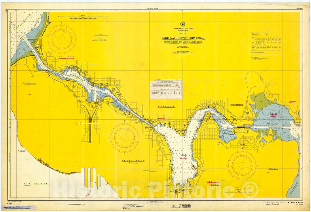
Historic Nautical Map - Lake Washington Ship Canal, 1956 NOAA Chart - Washington (WA) - Vintage Wall Art
From:
$49.99
Historic Nautical Map - Pend Oreille Lake, 1965 NOAA Chart - Idaho (ID) - Vintage Wall Art
From:
$49.99
Historic Nautical Map - Franklin D. Roosevelt Lake, Southern Part, 1971 NOAA Chart - Washington (WA) - Vintage Wall Art
From:
$49.99
Historic Nautical Map - Columbia River - Lake Celilo, 1972 NOAA Chart - Oregon (OR) - Vintage Wall Art
From:
$49.99
Historic Nautical Map - Lake Charles To Sabine River, 1961 NOAA Chart - Texas (TX) - Vintage Wall Art
From:
$49.99
Historic Nautical Map - Calcasieu Lake, 1965 NOAA Chart - Louisiana (LA) - Vintage Wall Art
From:
$49.99
Historic Nautical Map - Lake Champlain Sheet No. 2, 1874 NOAA Chart - New York, Vermont (NY, VT) - Vintage Wall Art
From:
$49.99
Historic Nautical Map - Presque Isle And Rockport Harbors Lake Huron, 1946 NOAA Chart - Michigan (MI) - Vintage Wall Art
From:
$49.99
Historic Nautical Map - Thunder Bay Lake Huron Morris Bay To Black River Michigan, 1913 NOAA Chart - Michigan (MI) - Vintage Wall Art
From:
$49.99
Historic Nautical Map - Sabine Pass And Lake, 1967 NOAA Chart - Louisiana, Texas (LA, TX) - Vintage Wall Art
From:
$49.99
Historic Nautical Map - South End Of Lake Huron Including Head Of St Clair River, 1954 NOAA Chart - Michigan (MI) - Vintage Wall Art
From:
$49.99
Historic Nautical Map - Lake Tahoe, 1971 NOAA Chart - California (CA) - Vintage Wall Art
From:
$49.99
icon-chevron-left
Previous
1
…
16
17
18
19
20
…
395
icon-chevron
Next
icon-X
"Close (esc)"
icon-chevron-left
icon-X
icon-chevron
icon-X
Lake Maps, Posters & Prints