Skip to content
icon-X
Close menu
Maps
World Maps
World War 2 Maps
Pictorial Maps
USGS TopoGraphic Maps
Art Prints
Blueprints
Fine Art Museum Collections
Claude Monet
Photographs
Modern Photos
Posters
Collections
Kid's Room
Autos, Trains & Rails
Monet and Manet
Brewery, Beer, Liquor & more
Holiday Ready to Gift Products
Log in
Follow Us
instagram
Instagram
Facebook
twitter
Twitter
Maps
World Maps
World War 2 Maps
Pictorial Maps
USGS TopoGraphic Maps
Art Prints
Blueprints
Fine Art Museum Collections
Claude Monet
Photographs
Modern Photos
Posters
Collections
Kid's Room
Autos, Trains & Rails
Monet and Manet
Brewery, Beer, Liquor & more
Holiday Ready to Gift Products
account
Log in
icon-search
Search
icon-hamburger
Site navigation
icon-bag-minimal
Cart
Search
Search
Free economy shipping for unframed orders of $75 or more!
Filter
icon-X
Close menu
Product type
Map
(75)
Topographic Map
(2)
Availability
In stock
(77)
Out of stock
(0)
Price
Michigan State Maps
icon-filter
Filter
Historic Map : 1851 Geological Map of the Lake Superior Land District in the State of Michigan : Vintage Wall Art
From:
$49.99
Historic Map - Department of The Interior General Land office Map - State of Michigan. 1878 - Vintage Wall Art
From:
$49.99
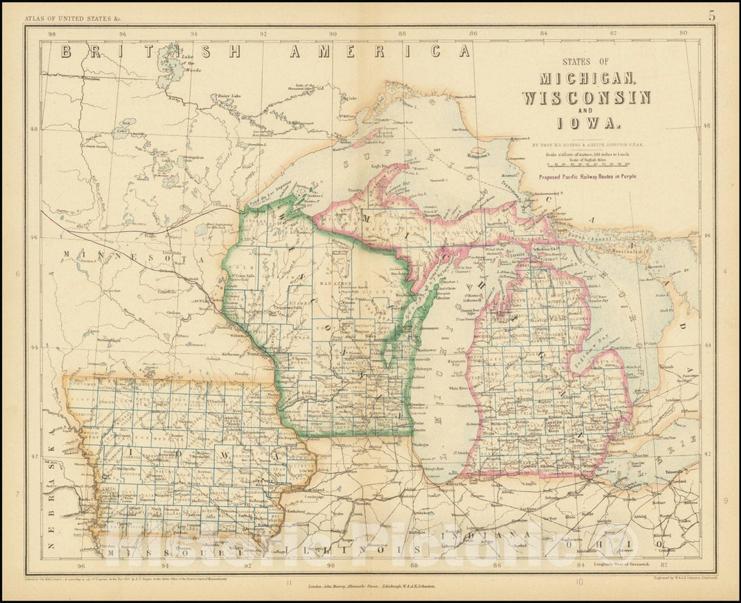
Historic Map : States of Michigan, Wisconsin, and Iowa, 1857, Vintage Wall Art
From:
$49.99
Historic Nautical Map - Outline Chart Of The United States, 1946 AeroNOAA Chart - Minnesota, Michigan, New York, Florida (MN, MI, NY, FL) - Vintage Wall Art
From:
$49.99
Historic 1939 Map - Official Transportation Map Michigan. - Atlases Of The United States - Michigan - Vintage Wall Art
From:
$34.99
Map : Michigan 1867, Map of the state of Michigan and the surrounding country exhibiting the sections and the latest surveys , Antique Vintage Reproduction
From:
$49.99
Map : Michigan and Wisconsin 1873 2, County and township map of the states of Michigan and Wisconsin , Antique Vintage Reproduction
From:
$49.99
Map : Stateline Lake, Michigan 1999, Stateline Lake, MI-WI , Antique Vintage Reproduction
From:
$49.99
Map : Michigan 1919, National highways map of the state of Michigan: showing thirty-nine hundred miles of national highways
From:
$34.99
Map : Michigan 1926, Michigan as a state 1860-1926, Antique Vintage Reproduction
From:
$49.99
Map : Wisconsin 1930, Wisconsin and Upper Michigan, state highway systems , Antique Vintage Reproduction
From:
$49.99
Map : Milwaukee, Wisconsin 1874, Plan of Milwaukee. County and township map of the states of Michigan and Wisconsin , Antique Vintage Reproduction
From:
$49.99
Map : Indiana, Ohio and the Territory of Michigan 1832, Map of the states of Indiana and Ohio with part of Michigan Territory , Antique Vintage Reproduction
From:
$49.99
Map : Michigan 1849, Sketch of the state of Michigan : showing the districts embraced in contracts for subdivisions north of Grand and Saganaw Rivers
From:
$34.99
Map : Michigan 1849, Diagram of the state of Michigan : showing the districts embraced in contracts for subdivisions north of Grand and Saganaw Rivers
From:
$34.99
Map : Michigan and Wisconsin 1873 1, County and township map of the states of Michigan and Wisconsin , Antique Vintage Reproduction
From:
$49.99
Map : Lake Saint Clair, Michigan and Ontario 2011, United States -- Great Lakes, Michigan, Lake St. Clair , Antique Vintage Reproduction
From:
$34.99
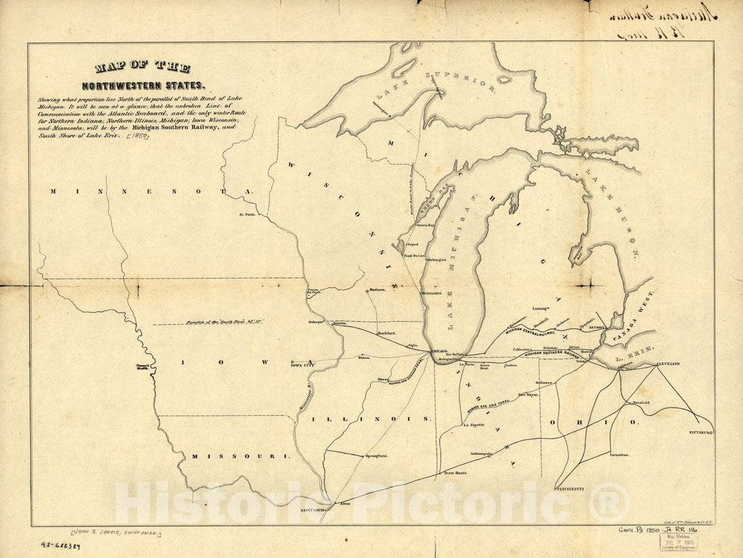
Historic 1850 Map - Map of The Northwestern States. Shewing sic What Proportion Lies North of The Parallel of South Bend of Lake Michigan.
From:
$49.99
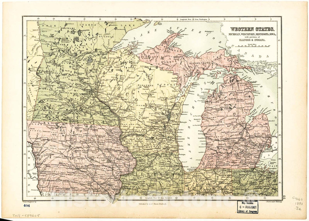
Historic 1873 Map - Western States, Michigan, Wisconsin, Minnesota, Iowa : with portions of Illinois & Indiana
From:
$49.99
1
2
3
…
5
icon-chevron
Next
icon-X
"Close (esc)"
icon-chevron-left
icon-X
icon-chevron
icon-X
Michigan State Wall Maps, Posters & Prints