Skip to content
icon-X
Close menu
Maps
World Maps
World War 2 Maps
Pictorial Maps
USGS TopoGraphic Maps
Art Prints
Blueprints
Fine Art Museum Collections
Claude Monet
Photographs
Modern Photos
Posters
Collections
Kid's Room
Autos, Trains & Rails
Monet and Manet
Brewery, Beer, Liquor & more
Holiday Ready to Gift Products
Log in
Follow Us
instagram
Instagram
Facebook
twitter
Twitter
Maps
World Maps
World War 2 Maps
Pictorial Maps
USGS TopoGraphic Maps
Art Prints
Blueprints
Fine Art Museum Collections
Claude Monet
Photographs
Modern Photos
Posters
Collections
Kid's Room
Autos, Trains & Rails
Monet and Manet
Brewery, Beer, Liquor & more
Holiday Ready to Gift Products
account
Log in
icon-search
Search
icon-hamburger
Site navigation
icon-bag-minimal
Cart
Search
Search
Free economy shipping for unframed orders of $75 or more!
Filter
icon-X
Close menu
Product type
Geologic Map
(1)
Map
(110)
Topographic Map
(2)
Availability
In stock
(113)
Out of stock
(0)
Price
Missouri State Maps
icon-filter
Filter
Historic Map : Map of that part of the State of Missouri? called Platte Country, 1842, Edward Hutawa, v1, Vintage Wall Art
From:
$49.99
Historic Map : Department of The Interior General Land office Map - State of Missouri. 1878 - Vintage Wall Art
From:
$49.99
Historic Map : States of Illinois, Missouri and Arkansas, 1857, Vintage Wall Art
From:
$49.99
Historic Map : United States Maps, Missouri 1894 , Vintage Wall Art
From:
$49.99
Historic 1830 Map - Western States - Northwest, Old - Kentucky - Ohio - Indiana - Missouri - Illinoismaps Of North America. - Vintage Wall Art
From:
$49.99
Historic Map : Missouri 1921 5, National highways map of the state of Missouri : showing forty-three hundred miles of national highways
From:
$29.99
Historic Map : Missouri 1921 4, National highways map of the state of Missouri : showing forty-three hundred miles of national highways
From:
$49.99
Historic Map : Missouri 1921 3, National highways map of the state of Missouri : showing forty-three hundred miles of national highways
From:
$34.99
Historic Map : Missouri 1921 1, National highways map of the state of Missouri : showing forty-three hundred miles of national highways
From:
$29.99
Historic Map : Missouri 1921 2, National highways map of the state of Missouri : showing forty-three hundred miles of national highways
From:
$29.99
Map : Compilation of records of surface waters of the United States, October 1950 to September 1960, part 6-B. Missouri River basin below Sioux City, Iowa, 1964 Cartography Wall Art :
From:
$39.99
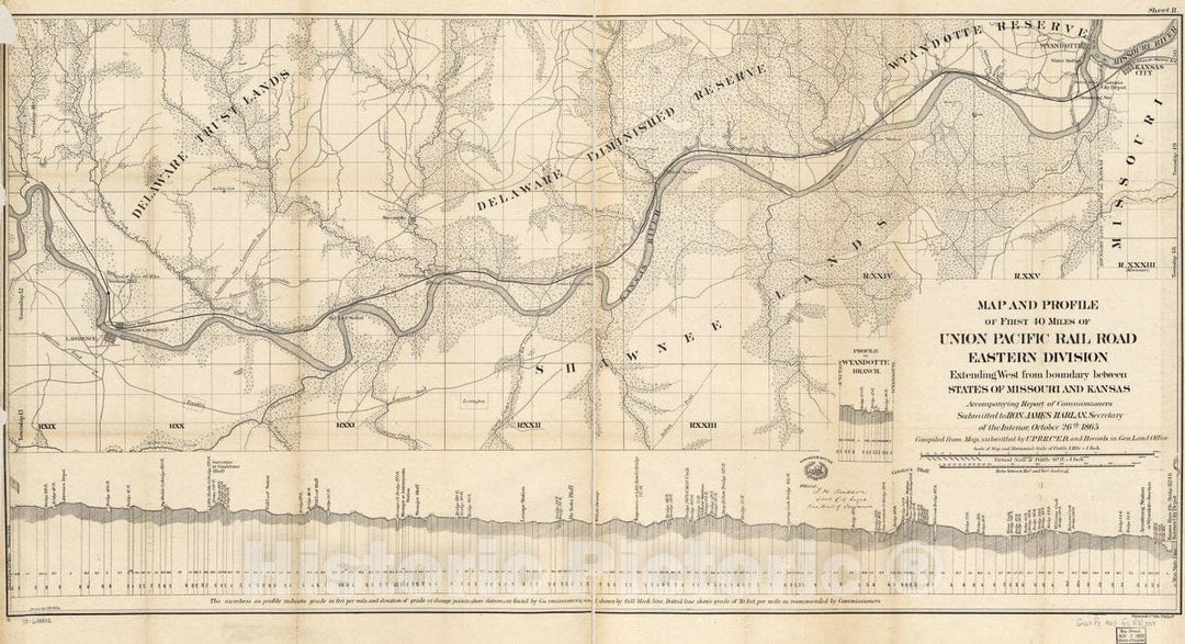
Historic 1865 Map - Map and Profile of First 40 Miles of Union Pacific Rail Road Eastern Division Extending west from Boundary Between States of Missouri and Kansas,
From:
$39.99
Historic 1876 Map - Map of The State of Nebraska Showing The Lands of The Burlington & Missouri RIV. R.R. Co. in Nebraska.
From:
$39.99
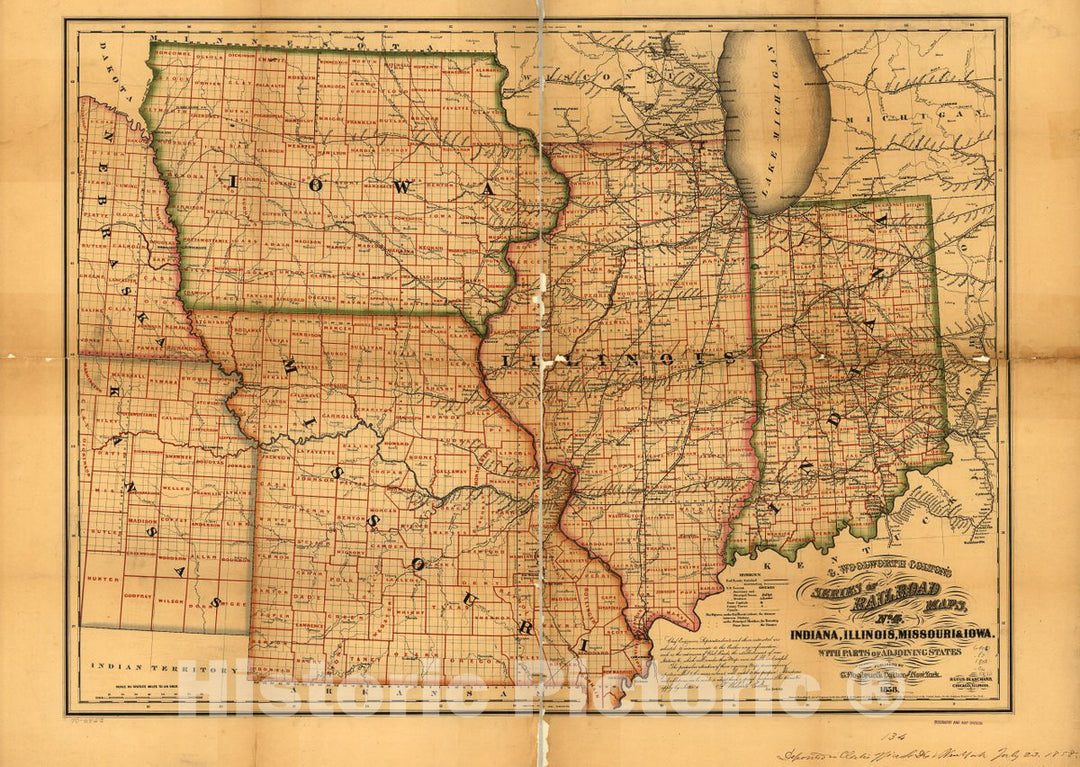
Historic 1858 Map - Indiana, Illinois, Missouri & Iowa with Parts of adjoining States.
From:
$49.99
Historic Map - A Collection of maps, Charts, Drawings, surveys, etc, Diagram of The State of Missouri 1
From:
$49.99
Historic 1868 Map - Map Showing The Iowa & Missouri State Line Railroad and its Connections.
From:
$34.99
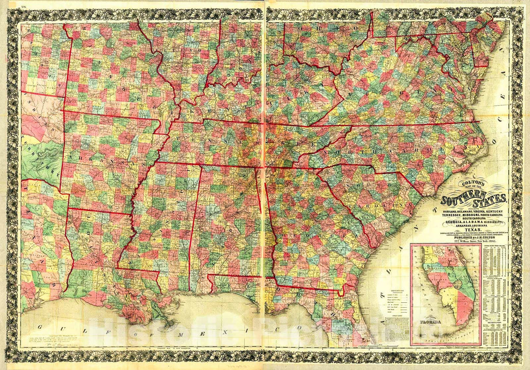
Historic 1862 Map - Colton's map of The Southern States, Including Maryland, Delaware, Virginia, Kentucky, Tennessee, Missouri, North Carolina, South Carolina, Georgia, Alabama, Miss
From:
$49.99
Historic 1863 Map - J. H. Colton's map of The Southern States. Maryland, Delaware, Virginia, Kentucky, Tennessee, Missouri, North Carolina, South Carolina, Georgia, Alabama, Mississippi,
From:
$49.99
Historic 1861 Map - Colton's map of The Southern States : Including Maryland, Delaware, Virginia, Kentucky, Tennessee, Missouri, North Carolina, South Carolina, Georgia, Alabama, Miss
From:
$49.99
1
2
3
…
6
icon-chevron
Next
icon-X
"Close (esc)"
icon-chevron-left
icon-X
icon-chevron
icon-X
Missouri State Wall Maps, Posters & Prints