icon

Free Shipping     |     Satisfaction Guaranteed

New Mexico State Maps

Showing products 1 - 54 of 54
Sort by:

Historic Map : United States Maps, New Mexico 1894 , Vintage Wall Art

United States Maps, New Mexico 1894
From: $49.99

Map : United States 1951, Automobile road map of the Indian Country : embracing portions of Arizona, New Mexico, Utah and Colorado , Antique Vintage Reproduction

Automobile road map of the Indian Country : embracing portions of Arizona, New Mexico, Utah and Colorado / copyrighted Automobile Club of Southern CaliforniaWe print high quality reproductions of historical...
From: $49.99

Map : New Mexico 1919, National highways map of the state of New Mexico : showing twenty-nine hundred miles of national highways, Antique Vintage Reproduction

National highways map of the state of New Mexico : showing twenty-nine hundred miles of national highways proposed by the National Highways Association / National Highways AssociationWe print high quality...
From: $49.99

Map : New Mexico 1921 1, National highways map of the state of New Mexico : showing twenty-nine hundred miles of national highways, Antique Vintage Reproduction

National highways map of the state of New Mexico : showing twenty-nine hundred miles of national highways proposed by the National Highways Association / National Highways Association ; John C....
From: $49.99

Historic Map : New Mexico 1916, State of New Mexico: lands designated by the Secretary of the Interior under the provisions of the enlarged Homestead Acts , Antique Vintage Reproduction

State of New Mexico: lands designated by the Secretary of the Interior under the provisions of the enlarged Homestead Acts / compiled by A.F. Dinsmore ; traced and lettered by...
From: $49.99

Map : New Mexico 1921 2, National highways map of the state of New Mexico : showing twenty-nine hundred miles of national highways, Antique Vintage Reproduction

National highways map of the state of New Mexico : showing twenty-nine hundred miles of national highways proposed by the National Highways Association / National Highways Association ; John C....
From: $49.99

Map : Red beds and associated formations in New Mexico, with an outline of the geology of the state [parts of Valencia, Socorro, and Catron Counties, pl.26], 1928 Cartography Wall Art :

Red beds and associated formations in New Mexico, with an outline of the geology of the state [parts of Valencia, Socorro, and Catron Counties, pl.26]We print high quality reproductions of...
From: $34.99

Map : Red beds and associated formations in New Mexico, with an outline of the geology of the state [part of central New Mexico, pl.17], 1928 Cartography Wall Art :

Red beds and associated formations in New Mexico, with an outline of the geology of the state [part of central New Mexico, pl.17]We print high quality reproductions of historical maps,...
From: $34.99

Map : Red beds and associated formations in New Mexico, with an outline of the geology of the state [north-central New Mexico, pl.24], 1928 Cartography Wall Art :

Red beds and associated formations in New Mexico, with an outline of the geology of the state [north-central New Mexico, pl.24]We print high quality reproductions of historical maps, photographs, prints,...
From: $34.99

Map : Red beds and associated formations in New Mexico, with an outline of the geology of the state [Zuni Mountain region, pl.33], 1928 Cartography Wall Art :

Red beds and associated formations in New Mexico, with an outline of the geology of the state [Zuni Mountain region, pl.33]We print high quality reproductions of historical maps, photographs, prints,...
From: $34.99

Map : Red beds and associated formations in New Mexico, with an outline of the geology of the state [San Andreas Mts., pl.40], 1928 Cartography Wall Art :

Red beds and associated formations in New Mexico, with an outline of the geology of the state [San Andreas Mts., pl.40]We print high quality reproductions of historical maps, photographs, prints,...
From: $34.99

Map : Red beds and associated formations in New Mexico, with an outline of the geology of the state [Sacramento Mountains, pl.44], 1928 Cartography Wall Art :

Red beds and associated formations in New Mexico, with an outline of the geology of the state [Sacramento Mountains, pl.44]We print high quality reproductions of historical maps, photographs, prints, etc....
From: $34.99

Map : Red beds and associated formations in New Mexico, with an outline of the geology of the state [Oscura Mts., Chupadera Mesa, Tularosa Valley, pl.42], 1928 Cartography Wall Art :

Red beds and associated formations in New Mexico, with an outline of the geology of the state [Oscura Mts., Chupadera Mesa, Tularosa Valley, pl.42]We print high quality reproductions of historical...
From: $49.99

Map : Red beds and associated formations in New Mexico, with an outline of the geology of the state [Nacimiento uplift and Chama basin, pl.37], 1928 Cartography Wall Art :

Red beds and associated formations in New Mexico, with an outline of the geology of the state [Nacimiento uplift and Chama basin, pl.37]We print high quality reproductions of historical maps,...
From: $49.99

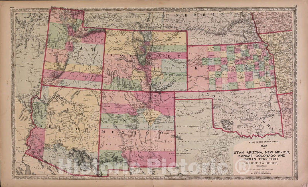
Historic 1870 Map - Atlas of Marshall Co. and The State of Illinois - Map of Utah, Arizona, New Mexico, Knasas, Colorado - Atlas of Marshall County and The State of Illinois

Atlas of Marshall Co. and the state of Illinois : to which is added an atlas of the United States, maps of the hemispheres &c. &c. &c.We print high quality...
From: $49.99

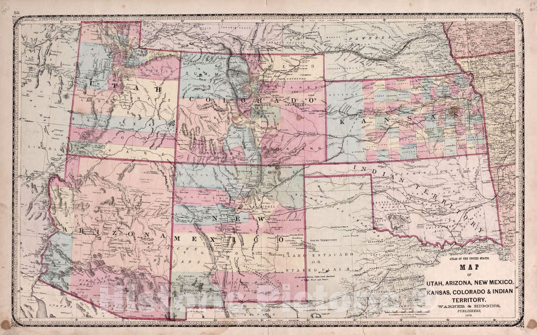
Historic 1870 Map - Atlas of Kendall Co. and The State of Illinois - Utah, Arizona, New Mexico, Kansas, Colorado & Indian Territory

Atlas of Kendall Co. and the state of Illinois : to which is added an atlas of the United States, maps of the hemispheres &c. &c. &c.We print high quality...
From: $49.99

Historic 1970 Map - The National Atlas of The United States of America. - Arizona and New Mexico

The national atlas of the United States of America.We print high quality reproductions of historical maps, photographs, prints, etc. Because of their historical nature, some of these images may show...
From: $49.99

Historic Map : 1940 State of New Mexico : Vintage Wall Art

Vintage Map | 1940 State of New Mexico | U.S. Geological Survey
From: $49.99

Historic Map : 1925 Geologic Map of the State of New Mexico : Vintage Wall Art

Vintage Map | 1925 Geologic Map of the State of New Mexico | Ellis, R.W.
From: $49.99

1985 Oasis State Park, NM - New Mexico - USGS Topographic Map

1985 Oasis State Park, NM - New Mexico - USGS Topographic Map
From: $49.99

2010 Oasis State Park, NM - New Mexico - USGS Topographic Map

2010 Oasis State Park, NM - New Mexico - USGS Topographic Map
From: $49.99

Historic Map - Map of the Territory of New Mexico Made, 1847, United States GPO - Vintage Wall Art

Map of the Territory of New Mexico Made , 1847, United States GPO
From: $49.99

Historic Map - The State Of California, The Territories Of Oregon & Utah, and the Chief part of New Mexico, 1851, Thomas, Cowperthwait & Co. v2

The State Of California, The Territories Of Oregon & Utah, and the Chief part of New Mexico, 1851, Thomas, Cowperthwait & Co.
From: $49.99

Historic Map - The State Of California, The Territories Of Oregon & Utah, and the Chief part of New Mexico, 1851, Thomas, Cowperthwait & Co. v1

The State Of California, The Territories Of Oregon & Utah, and the Chief part of New Mexico, 1851, Thomas, Cowperthwait & Co.
From: $49.99

Historic Map - The State Of California, The Territories Of Oregon, Washington, Utah & New Mexico, 1855, Charles Desilver - Vintage Wall Art

The State Of California, The Territories Of Oregon, Washington, Utah & New Mexico, 1855, Charles Desilver
From: $49.99

Historic Map - Vereinigte Staaten von Nord-America: Californien, Texas und die Territorien New Mexico u. :: German of the Texas and Southwestern United States, 1852 - Vintage Wall Art

Vereinigte Staaten von Nord-America: Californien, Texas und die Territorien New Mexico u. :: German of the Texas and Southwestern United States, 1852
From: $49.99

Historic Map - Map of the Territory of New Mexico Made, 1847, United States GPO - Vintage Wall Art

Map of the Territory of New Mexico Made , 1847, United States GPOWe print high quality reproductions of historical maps, photographs, prints, etc. Because of their historical nature, some of...
From: $49.99

Historic Map - Navajo Nation Reservation - Parts of Arizona, New Mexico & Utah, 1893, United States Department of the Interior - Vintage Wall Art

Navajo Nation Reservation -- Parts of Arizona, New Mexico & Utah, 1893, United States Department of the InteriorWe print high quality reproductions of historical maps, photographs, prints, etc. Because of...
From: $49.99

Historic Map - The State Of California, The Territories Of Oregon, Washington, Utah & New Mexico, 1853, Thomas, Cowperthwait & Co. v4

The State Of California, The Territories Of Oregon, Washington, Utah & New Mexico, 1853, Thomas, Cowperthwait & Co.We print high quality reproductions of historical maps, photographs, prints, etc. Because of...
From: $49.99

Historic Map - James S. Calhoun's Annotated Copy) Map of the Territory of New Mexico Made, 1850, United States GPO - Vintage Wall Art

James S. Calhoun's Annotated Copy) Map of the Territory of New Mexico Made, 1850, United States GPOWe print high quality reproductions of historical maps, photographs, prints, etc. Because of their...
From: $49.99

Historic Map - The State Of California, The Territories Of Oregon & Utah, and the Chief part of New Mexico, 1851, Thomas, Cowperthwait & Co. - Vintage Wall Art

The State Of California, The Territories Of Oregon & Utah, and the Chief part of New Mexico, 1851, Thomas, Cowperthwait & Co.We print high quality reproductions of historical maps, photographs,...
From: $49.99

Historic Map - Nebraska, Kansas, New Mexico And Indian Territories [Rare First State!], 1855, Charles Desilver - Vintage Wall Art

Nebraska, Kansas, New Mexico And Indian Territories [Rare First State!], 1855, Charles DesilverWe print high quality reproductions of historical maps, photographs, prints, etc. Because of their historical nature, some of...
From: $49.99

Historic Map : Map of the Territory of New Mexico, 1894, United States Department of the Interior, Vintage Wall Art

Map of the Territory of New Mexico, 1894, United States Department of the Interior
From: $49.99

Historic Map : Exploring Expedition to New Mexico and the Southern Rocky Mountains, 1845, United States Bureau of Topographical Engineers, Vintage Wall Art

Exploring Expedition to New Mexico and the Southern Rocky Mountains, 1845, United States Bureau of Topographical Engineers
From: $49.99

Historic Map : The Mammoth Map of the United States Sheet NO. 9 (Colorado, New Mexico etc.), c1877, , Vintage Wall Art

The Mammoth Map of the United States Sheet NO. 9 (Colorado, New Mexico etc.), c1877,
From: $49.99

Historic Map - North America Sheet XV - Utah, New Mexico, Texas, California,and the Northern States of Mexico, 1859, SDUK - Vintage Wall Art

North America Sheet XV - Utah, New Mexico, Texas, California,and the Northern States of Mexico, 1859, SDUKWe print high quality reproductions of historical maps, photographs, prints, etc. Because of their...
From: $49.99

Historic Map - Circoscrizione Ecclesiastica Negli Stati Uniti/Provinces of the United States, St. Louis, including New Mexico, Tennessee, 1858, Girolomo Petri - Vintage Wall Art

Circoscrizione Ecclesiastica Negli Stati Uniti / Provinces of the United States, St. Louis, including New Mexico, Tennessee, 1858, Girolomo PetriWe print high quality reproductions of historical maps, photographs, prints, etc....
From: $49.99

Historic Map - The State Of California, The Territories Of Oregon, Washington, Utah & New Mexico, 1853, Thomas, Cowperthwait & Co. v3

The State Of California, The Territories Of Oregon, Washington, Utah & New Mexico, 1853, Thomas, Cowperthwait & Co.We print high quality reproductions of historical maps, photographs, prints, etc. Because of...
From: $49.99

Historic Map - The State Of California, The Territories Of Oregon, Washington, Utah & New Mexico, 1856, Charles Desilver - Vintage Wall Art

The State Of California, The Territories Of Oregon, Washington, Utah & New Mexico, 1856, Charles DesilverWe print high quality reproductions of historical maps, photographs, prints, etc. Because of their historical...
From: $49.99

Historic Map - The State Of California, The Territories Of Oregon, Washington, Utah & New Mexico, 1853, Thomas, Cowperthwait & Co. v2

The State Of California, The Territories Of Oregon, Washington, Utah & New Mexico, 1853, Thomas, Cowperthwait & Co.We print high quality reproductions of historical maps, photographs, prints, etc. Because of...
From: $49.99

Historic Map - The State Of California, The Territories Of Oregon, Washington, Utah & New Mexico, 1852, Thomas, Cowperthwait & Co. v2

The State Of California, The Territories Of Oregon, Washington, Utah & New Mexico, 1852, Thomas, Cowperthwait & Co.We print high quality reproductions of historical maps, photographs, prints, etc. Because of...
From: $49.99

Historic Map - The State Of California, The Territories Of Oregon, Washington, Utah & New Mexico, 1854, Thomas, Cowperthwait & Co. v2

The State Of California, The Territories Of Oregon, Washington, Utah & New Mexico, 1854, Thomas, Cowperthwait & Co.We print high quality reproductions of historical maps, photographs, prints, etc. Because of...
From: $49.99

Historic Map - The State Of California, The Territories Of Oregon, Washington, Utah & New Mexico, 1852, Thomas, Cowperthwait & Co. v1

The State Of California, The Territories Of Oregon, Washington, Utah & New Mexico, 1852, Thomas, Cowperthwait & Co.We print high quality reproductions of historical maps, photographs, prints, etc. Because of...
From: $49.99

Historic Map - The State Of California, The Territories Of Oregon, Washington, Utah & New Mexico, 1854, Thomas, Cowperthwait & Co. v1

The State Of California, The Territories Of Oregon, Washington, Utah & New Mexico, 1854, Thomas, Cowperthwait & Co.We print high quality reproductions of historical maps, photographs, prints, etc. Because of...
From: $49.99

Historic Map - The State Of California, The Territories Of Oregon, Washington, Utah & New Mexico, 1853, Thomas, Cowperthwait & Co. v1

The State Of California, The Territories Of Oregon, Washington, Utah & New Mexico, 1853, Thomas, Cowperthwait & Co.We print high quality reproductions of historical maps, photographs, prints, etc. Because of...
From: $49.99

Historic Map : Old Territory and Military Department of New Mexico, 1863, United States Bureau of Topographical Engineers, Vintage Wall Art

Old Territory and Military Department of New Mexico, 1863, United States Bureau of Topographical Engineers
From: $49.99

Historic Map : State of New Mexico. General Land Office., 1927, Vintage Wall Decor

State of New Mexico. General Land Office., 1927, Vintage Wall Decor
From: $49.99

Historic Map : Wall Map, United States, Mexico, Central America, California, Oregon, New Mexico, W. Indies &c. 1851 - Vintage Wall Art

A map of the United States, Mexico, Central America, California, Oregon, New Mexico, W. Indies &c. With the boundaries, of the several states, railroads, canals &c. by H.S. Tanner, No....
From: $49.99