-
-


-
Wall Color
in
Uncheck to hide the white line Check to show the white line -
-
.


Frame
Room
Gallery
Historic Map : Knapp Map of The Southeast Corner of Central Park (Grand Army Plaza) New York City, 1869, Vintage Wall Art
Historic Map : Knapp Map of The Southeast Corner of Central Park (Grand Army Plaza) New York City, 1869, Vintage Wall Art
Note: Sold out or unavailable
Couldn't load pickup availability
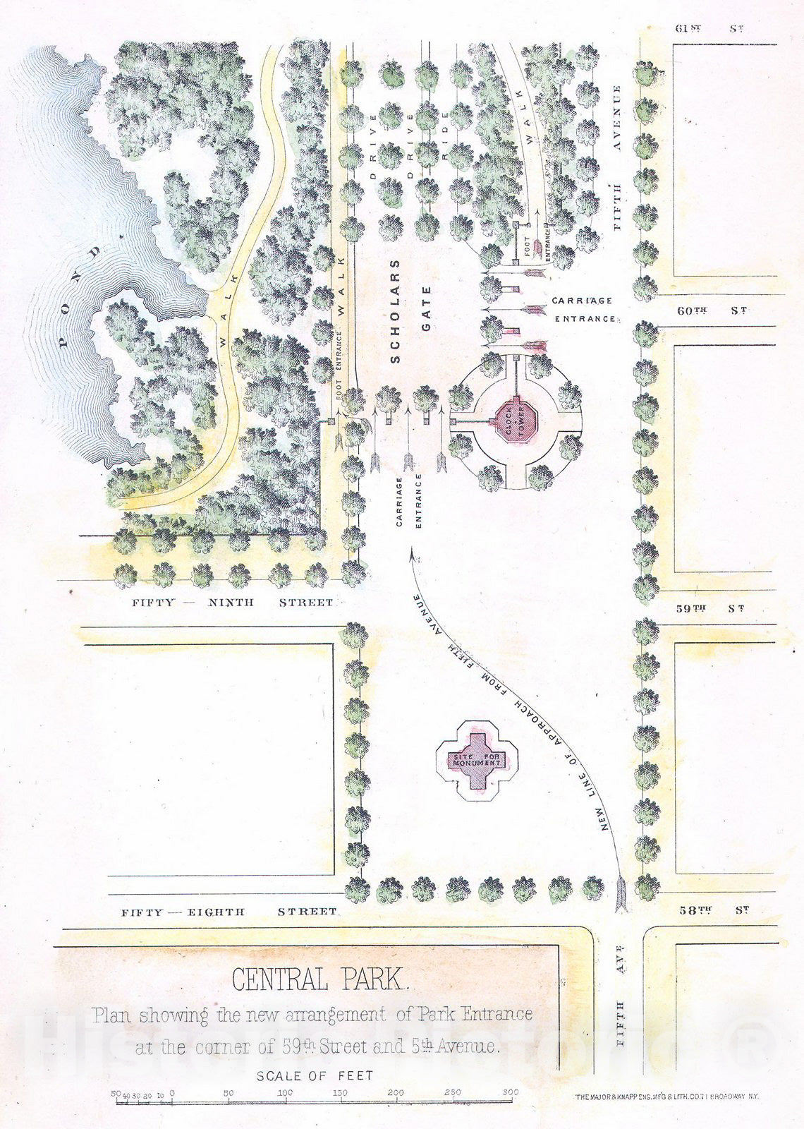
An unusual little map of the southeastern corner of New York City's Central Park. Depicts from 61st Street south to the intersection of 58th street and 5th Avenue . Shows the planned ornamentation and redirection of traffic to accommodate the park drives. Shows the clock tower, the then proposed monument that now sits in front of the former Plaza Hotel and Bergdorf Goodman. Also depicts the locations of trees, the ponds, and various walkways. A nice little map of one of the poshest part of Manhattan, Grand Army Plaza. This map was published for inclusion in the 1869 13th Annual Report of the Commissioners of Central Park . On the Central Park: Vaux and Olmstead were awarded the task of designing Central Park in 1853 by the City Common Council. Olmstead's vision drove the overall design while Vaux concentrated his attentions on bridges, buildings, and other structures within the park. The creation of Central Park, which was to consist of some 800 acres of public forest, pathways, promenades, lakes, bridges, and meadows, was a seminal moment in civic urban design. The park itself was designed as a whole with every tree, pond, and bench meticulously planned. Olmstead wrote: "Every foot of the parks surface, every tree and bush, as well as every arch, roadway, and walk and been placed where it is for a purpose." Historian Gloria Deak writes, "There was a staggering amount of work to be done to transform the area into a blend of pastoral and woodland scenery. It also involved the supervision of an army of about five thousand laborers…Olmsted, to whom most of the credit goes, insisted on seeing the multidimensional project as a single work of art, which he was mandated to create. For this purpose, he ventured to assume to himself the title of 'artist.'" Today, because of Vaux and Olmstead's efforts, New York Yorkers, ourselves included, have the privlidge of enjoying what is, perhaps, the finest example of a planned urban public recreation area in the world.
- MUSEUM QUALITY INKS AND PAPER: Printed on thick 192gsm heavyweight matte paper with archival giclee inks, this historic fine art will decorate your wall for years to come.
- VINTAGE MAP REPRODUCTION: Add style to any room's decor with this beautiful print. Whether your interior design is modern or classic, a map is never out of fashion.
- ATTENTION TO DETAIL: We edit every antique map for image quality, color and vibrance, so it can look its best while retaining historical character. Makes a great gift!
- FRAME READY: Your unframed poster will arrive crease-free, rolled in a sturdy mailing tube. Many maps fit easy-to-find standard size frames 16x20, 16x24, 18x24, 24x30, 24x36, saving on custom framing.
- Watermarks will not appear in the printed picture. Some blemishes, tears, or stamps may be removed from the final print.
What our customers are saying
★★★★★I purchased an historic map, 16x24 inch. It is beautifully printed on heavy stock. The lettering, colors, and details of the map are crisp and easy to read. I am highly satisfied and would certainly purchase from Historic Pictoric again!
Kent A.
★★★★★Ordered the Pan American Midway print to fit a lovely thrift-store gilded frame. I love showing off Buffalo's rich history and this is a pretty entertaining photo from 1901. Prompt shipping. Sturdy packaging.
Cindy O.
★★★★★I received my print within days of ordering, and it arrived well packed in a mailing tube. The print is high quality and exactly as advertised. I will use Historic Pictoric again in the future!
Cheryl H.
★★★★★Excellent product. Great fidelity in reproduction of the original. Fine/minute details were sharp, colors were vibrant, and thickness, texture and overall feel and quality of the paper were excellent. Very satisfied with my purchase.
Konrad B.
★★★★★I have purchased six maps from Historic Pictoric. I find the quality to be excellent. Their customers service is also excellent. Outstanding! I called to exchange a few for different sizes and I could not have asked for a better experience.
Aaron C.
★★★★★The original map I ordered lacked some of the detail that I had hoped for, but they responded with several more map possibilities to choose from. Excellent service- a far step beyond what anyone expects from online purchases.
Dan M.
★★★★★I am a owner of 5 maps from Historic Pictoric. From Okinawa, 1945, Europe 1940-1945 battle maps. Now they’re helping me with the battle of Gettysburg. These maps are so much superior to the map on a page in a book. I have framed two of them.
Steven Ko
★★★★★Great heavy paper quality and clarity of my nautical map. Will be a great addition to our home close to the beach!
Jennifer A

