Skip to content
icon-X
Close menu
Maps
World Maps
World War 2 Maps
Pictorial Maps
USGS TopoGraphic Maps
Art Prints
Blueprints
Fine Art Museum Collections
Claude Monet
Photographs
Modern Photos
Posters
Collections
Kid's Room
Autos, Trains & Rails
Monet and Manet
Brewery, Beer, Liquor & more
Holiday Ready to Gift Products
Log in
Follow Us
instagram
Instagram
Facebook
twitter
Twitter
Maps
World Maps
World War 2 Maps
Pictorial Maps
USGS TopoGraphic Maps
Art Prints
Blueprints
Fine Art Museum Collections
Claude Monet
Photographs
Modern Photos
Posters
Collections
Kid's Room
Autos, Trains & Rails
Monet and Manet
Brewery, Beer, Liquor & more
Holiday Ready to Gift Products
account
Log in
icon-search
Search
icon-hamburger
Site navigation
icon-bag-minimal
Cart
Search
Search
Free economy shipping for unframed orders of $75 or more!
Filter
icon-X
Close menu
Product type
Architectural Blueprint
(1)
Color Photo
(1)
Geologic Map
(216)
Map
(4194)
Availability
In stock
(4414)
Out of stock
(1)
Price
United States Maps
icon-filter
Filter
Historic Map : Map of the United States, Published by S. Walker, Boston, 1854 , Vintage Wall Art
From:
$49.99
Historic Map : This map presents a Bostonian's idea of the United States of America, c. 1939 , Vintage Wall Art
From:
$49.99
Historic Map : A Diagram of the Triangulation for the Survey of the Coast of the United States, 1834 , Vintage Wall Art
From:
$49.99
Historic Map : United States- East Coast Maine Quoddy Roads to Petit Manan Island, 1929 , Vintage Wall Art
From:
$49.99
Historic Map : Map showing the Territorial Growth of the United States 1776-1887, 1888 , Vintage Wall Art
From:
$49.99
Historic Map : United States, Maine--east coast, Portland Harbor and vicinity, 1995 , Vintage Wall Art
From:
$49.99
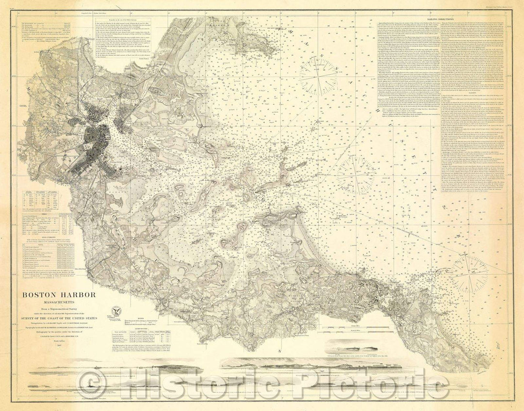
Historic Map : Boston Harbor, Massachusetts: Survey of the Coast of the United States, 1867 , Vintage Wall Art
From:
$49.99
Historic Map : The Official Map of Maine compiled from United States government surveys, official state surveys, and original sources; L.V. Crocker, Topographer., 1918 , Vintage Wall Art
From:
$49.99
Historic Map : Map of the United States Constructed from the Latest Authorities., 1834 , Vintage Wall Art
From:
$49.99
Historic Map : Gray's Geological Map of the United States, 1875 , Vintage Wall Art
From:
$49.99
Historic Map : United States-- East Coast Maine: From Penobscot Bay to Kennebec Entrance, 1916 , Vintage Wall Art
From:
$49.99
Historic Map : Military Map of the United States and Territories Showing the Location of the Military Posts, Arsenals, Navy Yards, and Ports of Entry, 1861 , Vintage Wall Art
From:
$49.99
Historic Map : Boston Harbor Massachusetts Survey of the Coast of the United States, 1867 , Vintage Wall Art
From:
$49.99
Historic Map : United States Showing Disposition of Lands, 1894 , Vintage Wall Art
From:
$49.99
Historic Map : Conoco Highway Map of United States, 1950 , Vintage Wall Art
From:
$49.99
Historic Map : Conoco Highway Map of United States featuring mileage and driving time along main transcontinental highways., c. 1950 , Vintage Wall Art
From:
$49.99
Historic Map : Standard Oil Company Indiana; Highway Map Southwestern Section of the United States, 1942 , Vintage Wall Art
From:
$49.99
Historic Map : New Pocket Map of Boston and Surrounding Country. Engraved Expressly for the Guests of the United States Hotel, 1889 , Vintage Wall Art
From:
$39.99
Historic Map : U.S. Coast Survey, A. D. Bache. Superintendent, Reconnaissance of the Western Coast of the United States from Gray's Harbor to the Entrance of Admiral, 1853 , Vintage Wall Art
From:
$49.99
icon-chevron-left
Previous
1
…
11
12
13
14
15
…
233
icon-chevron
Next
icon-X
"Close (esc)"
icon-chevron-left
icon-X
icon-chevron
icon-X
United States Wall Maps, Posters & Prints