Skip to content
icon-X
Close menu
Maps
World Maps
World War 2 Maps
Pictorial Maps
USGS TopoGraphic Maps
Art Prints
Blueprints
Fine Art Museum Collections
Claude Monet
Photographs
Modern Photos
Posters
Collections
Kid's Room
Autos, Trains & Rails
Monet and Manet
Brewery, Beer, Liquor & more
Holiday Ready to Gift Products
Log in
Follow Us
instagram
Instagram
Facebook
twitter
Twitter
Maps
World Maps
World War 2 Maps
Pictorial Maps
USGS TopoGraphic Maps
Art Prints
Blueprints
Fine Art Museum Collections
Claude Monet
Photographs
Modern Photos
Posters
Collections
Kid's Room
Autos, Trains & Rails
Monet and Manet
Brewery, Beer, Liquor & more
Holiday Ready to Gift Products
account
Log in
icon-search
Search
icon-hamburger
Site navigation
icon-bag-minimal
Cart
Search
Search
Free economy shipping for unframed orders of $75 or more!
Filter
icon-X
Close menu
Product type
Architectural Blueprint
(1)
Color Photo
(1)
Geologic Map
(216)
Map
(4194)
Availability
In stock
(4414)
Out of stock
(1)
Price
United States Maps
icon-filter
Filter
Historical Map, 1822 Plan of The City of Washington, seat of Government of The United States, Vintage Wall Art
From:
$49.99
Historical Map, ca. 1904 Map Showing Lines of The Bell Telephone Companies in The United States and Canada : July 1st, 1904, Vintage Wall Art
From:
$49.99
Historical Map, 1842 Map of The River Sabine from Logan's Ferry to 32nd Degree of North Latitude : shewing The Boundary Between The United States of America, Vintage Wall Art
From:
$49.99
Historical Map, 1887 Plan of The City Intended for The Permanent seat of The Government of t[he] United States, Vintage Wall Art
From:
$49.99
Historical Map, 1845 Map of The United States of America : Including Canada and a Large Portion of Texas Showing The Base Meridian and Township Lines of The U.S, Vintage Wall Art
From:
$49.99
Historical Map, 1867 North Western America Showing The Territory ceded by Russia to The United States, Vintage Wall Art
From:
$59.99
Historical Map, 1884 Transportation Lines Between The United States and Mexico, Showing Differences of Elevation, Vintage Wall Art
From:
$49.99
Historical Map, 1800 Plat of The Seven ranges of townships Being pof The Territory of The United States n.w. of The Ohio River which by a Late act of Congress, Vintage Wall Art
From:
$49.99
Historical Map, 1882 Plan of the city intended for the permanent seat of the government of the United States, Vintage Wall Art
From:
$49.99
Historical Map, 1825 Plat of The United States Road from Detroit to Chicago [Sheet 1], Vintage Wall Art
From:
$49.99
Historical Map, 1825 Plat of The United States Road from Detroit to Chicago [Sheet 3], Vintage Wall Art
From:
$49.99
Historical Map, 1860 Map of the Parish of Tensas, Louisiana : from United States Surveys, Vintage Wall Art
From:
$49.99
Historical Map, 1828-1836 Map of The United States : intending chiefly to Exhibit The Post Roads & Distances, Vintage Wall Art
From:
$49.99
Historical Map, 1794 A New and General map of The Southern dominions Belonging to The United States of America, viz North Carolina, South Carolina, and Georgia, Vintage Wall Art
From:
$49.99
Historical Map, 1796 Map of The United States exhibiting The Post-Roads, The situations, Connections & Distances of The Post-Offices, Stage Roads, Counties, Port, Vintage Wall Art
From:
$34.99
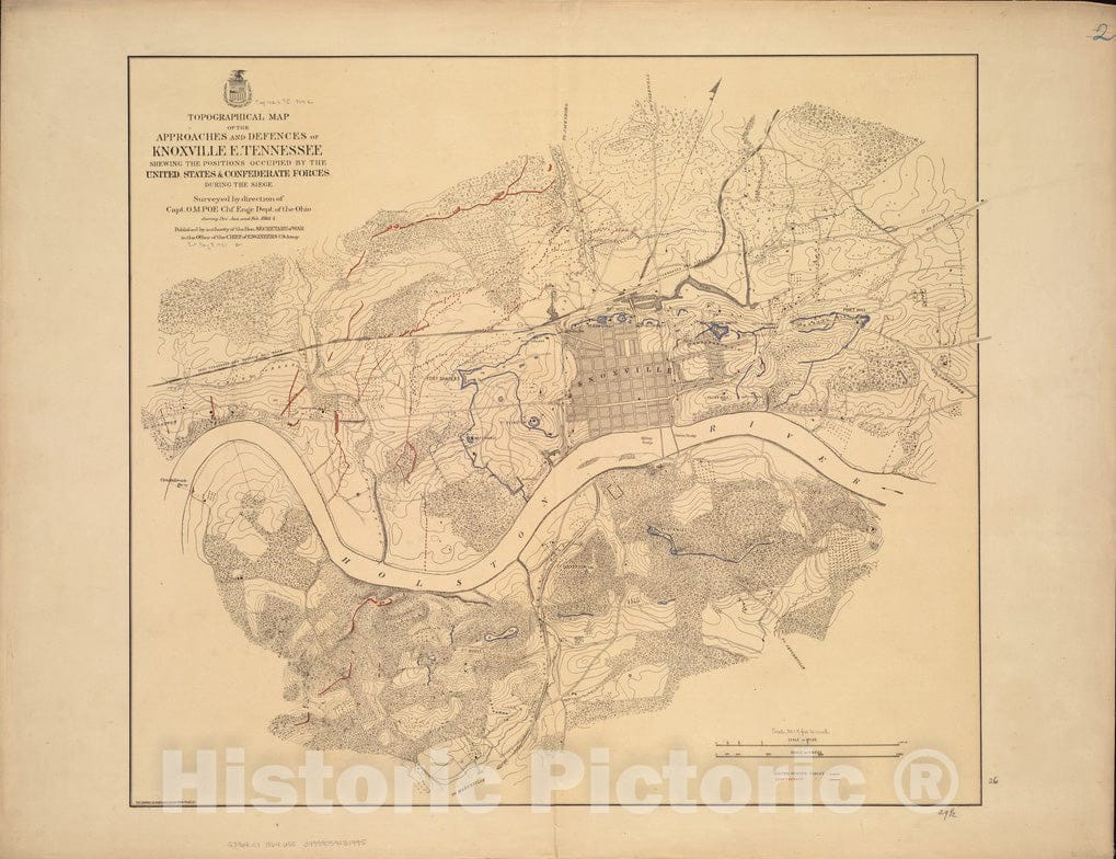
Historical Map, 1864 Topographical map of The approaches and defences of Knoxville, E. Tennessee, shewing The Positions Occupied by The United States & Confederate, Vintage Wall Art
From:
$49.99
Historical Map, 1864 Map of The South Western Part of The United States : Constructed and Engraved to illustrate 'The War with The South', Vintage Wall Art
From:
$49.99
Historical Map, Outline map of Massachusetts showing population according to the United States census of 1890, Vintage Wall Art
From:
$49.99
Historical Map, 1896 Distribution of The Magnetic Declination in The United States in 1900, Vintage Wall Art
From:
$49.99
icon-chevron-left
Previous
1
…
211
212
213
214
215
…
233
icon-chevron
Next
icon-X
"Close (esc)"
icon-chevron-left
icon-X
icon-chevron
icon-X
United States Wall Maps, Posters & Prints


![Historical Map, 1887 Plan of The City Intended for The Permanent seat of The Government of t[he] United States, Vintage Wall Art](http://www.historicpictoric.com/cdn/shop/products/5134809_1wmark.jpg?v=1683492611&width=1080)


![Historical Map, 1825 Plat of The United States Road from Detroit to Chicago [Sheet 1], Vintage Wall Art](http://www.historicpictoric.com/cdn/shop/products/5134584_1wmark.jpg?v=1683492621&width=1080)
![Historical Map, 1825 Plat of The United States Road from Detroit to Chicago [Sheet 3], Vintage Wall Art](http://www.historicpictoric.com/cdn/shop/products/5134574_1wmark.jpg?v=1683225198&width=1080)