Skip to content
icon-X
Close menu
Maps
World Maps
World War 2 Maps
Pictorial Maps
USGS TopoGraphic Maps
Art Prints
Blueprints
Fine Art Museum Collections
Claude Monet
Photographs
Modern Photos
Posters
Collections
Kid's Room
Autos, Trains & Rails
Monet and Manet
Brewery, Beer, Liquor & more
Holiday Ready to Gift Products
Log in
Follow Us
instagram
Instagram
Facebook
twitter
Twitter
Maps
World Maps
World War 2 Maps
Pictorial Maps
USGS TopoGraphic Maps
Art Prints
Blueprints
Fine Art Museum Collections
Claude Monet
Photographs
Modern Photos
Posters
Collections
Kid's Room
Autos, Trains & Rails
Monet and Manet
Brewery, Beer, Liquor & more
Holiday Ready to Gift Products
account
Log in
icon-search
Search
icon-hamburger
Site navigation
icon-bag-minimal
Cart
Search
Search
Free economy shipping for unframed orders of $75 or more!
Filter
icon-X
Close menu
Product type
Architectural Blueprint
(1)
Geologic Map
(2)
Map
(182)
Topographic Map
(1)
Availability
In stock
(186)
Out of stock
(0)
Price
Virginia State Maps
icon-filter
Filter
Historic Map : 1928 Topographic Map of the State of Virginia : Vintage Wall Art
From:
$29.99
Historic Map - States of Virginia, North Carolina, South Carolina and Georgia; Comprehending the Spanish Provinces of East and West Florida: Exhibiting, 1792 - Vintage Wall Art
From:
$49.99
Historic Map : A New Map of the State of Virginia : Published by Charles Desilver, 1859 - Vintage Wall Art
From:
$49.99
Historic Map : Lloyd's official map of the State of Virginia, 1862 - Vintage Wall Art
From:
$49.99
Historic Map : States of Delaware, Maryland, Virginia, with District of Columbia, 1857, Vintage Wall Art
From:
$49.99
Historic Map : The United States as Virginians See It, 1950, Vintage Wall Art
From:
$49.99
Historic Map : Plan of the City of Washington in the Territory of Columbia, ceded by the States of Virginia and Maryland to the United States of America, 1792 , Vintage Wall Art
From:
$49.99
Historic Map : Map of the Chief Part of the Western States and Part of Virginia, 1839 , Vintage Wall Art
From:
$49.99
Historic Map : Map of the Chief Part of the Western States and Part of Virginia Engraved to Illustrate Mitchell's School and Family Geography., 1839 , Vintage Wall Art
From:
$49.99
Historic Map : A New Map of Part of the United States of North America, exhibiting the Western Territory, Kentucky, Pennsylvania, Maryland, Virginia, 1805 , Vintage Wall Art
From:
$29.99
Historic Nautical Map - Map Of The United States Pt. 2, 1954 AeroNOAA Chart - West Virginia, New York, Pennsylvania, Maryland (WV, NY, PA, MD) - Vintage Wall Art
From:
$49.99
Historic Map : United States Maps, West Virginia 1894 , Vintage Wall Art
From:
$49.99
Historic Map : United States Maps, Virginia 1894 , Vintage Wall Art
From:
$49.99
Historic 1792-01-25 Map - A Map Of The States Of Virginia, North Carolina, South Carolina - Vintage Wall Art
From:
$49.99
Historic 1651 Map - Virginia Nieu Neder-Landt. Nieu Engelandt. - Atlantic States - Bermuda Islandsamerican Historical Prints. - Vintage Wall Art
From:
$49.99
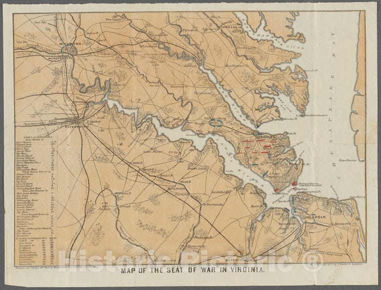
Historic 1862 Map - Map Of The Seat Of War In Virginia - United States - Virginiamaps Of North America. - Collection Of Civil War Maps - Vintage Wall Art
From:
$49.99
Historic 1743 Map - Virginia, Maryland, Pennsilvania, East & West New Jarsey. - Middle Atlantic States - Charts And Maps - Vintage Wall Art
From:
$49.99
Historic 1636 Map - Nova Anglia, Novum Belgium, Et Virginia. - Middle Atlantic States - New England - Virginia - Charts And Maps - Vintage Wall Art
From:
$49.99
Historic 1689 Map - Virginia, Maryland, Pennsilvania, East & West New Jarsey. - Middle Atlantic States - Charts And Maps - Vintage Wall Art
From:
$49.99
1
2
3
…
10
icon-chevron
Next
icon-X
"Close (esc)"
icon-chevron-left
icon-X
icon-chevron
icon-X
Virginia State Wall Maps, Posters & Prints