icon

Free Shipping     |     Satisfaction Guaranteed

Wyoming State Maps

Showing products 1 - 33 of 33
Sort by:

Historic Map : Railway Distance Map of the State of Wyoming, 1934 - Vintage Wall Art

Leahy's Hotel Guide and Railway Distance Map of the State of Wyoming. Published by American Hotel Register Company. Leahy Build., 228-234 W. Ontario St., Chicago, Ill. Copyrighted by J.F. Leahy,...
From: $49.99

Historic Map : United States Maps, Wyoming 1894 , Vintage Wall Art

United States Maps, Wyoming 1894
From: $49.99

Historic Map : Atlas State of Rhode Island, Laureldale & Locustville & Potters Hill & Wyoming 1870 , Vintage Wall Art

Atlas of The State of Rhode Island, Laureldale & Locustville & Potters Hill & Wyoming 1870
From: $49.99

Map : United States 1950 4, Dakotas with Idaho-Montana-Wyoming, Antique Vintage Reproduction

Dakotas with Idaho-Montana-Wyoming/ Rand, McNally & Co.We print high quality reproductions of historical maps, photographs, prints, etc. Because of their historical nature, some of these images may show signs of...
From: $49.99

Historic Map : Wyoming 1916, State of Wyoming : lands designated by the Secretary of the Interior under the provisions of the Enlarged Homestead Acts , Antique Vintage Reproduction

State of Wyoming : lands designated by the Secretary of the Interior under the provisions of the Enlarged Homestead Acts / Department of the Interior ; compiled and drawn by...
From: $34.99

Map : Wyoming 1905, State of Wyoming , Antique Vintage Reproduction

State of Wyoming / compiled from official records of the General Land Office and other sources, under the direction of Frank Bond, Chief of Drafting Division G.L.O ; compiled and...
From: $34.99

Map : United States 1950 6, Dakotas with Idaho-Montana-Wyoming, Antique Vintage Reproduction

Dakotas with Idaho-Montana-Wyoming/ Rand, McNally & Co.We print high quality reproductions of historical maps, photographs, prints, etc. Because of their historical nature, some of these images may show signs of...
From: $49.99

Historic Map : Wyoming 1919 1, National highways map of the state of Wyoming : showing thirty-four hundred miles of national highways

National highways map of the state of Wyoming : showing thirty-four hundred miles of national highways proposed by the National Highways Association / National Highways Association ; John C. Mulford,...
From: $34.99

Historic Map : Wyoming 1919 2, National highways map of the state of Wyoming : showing thirty-four hundred miles of national highways

National highways map of the state of Wyoming : showing thirty-four hundred miles of national highways proposed by the National Highways Association / National Highways Association ; John C. Mulford,...
From: $34.99

Map : Stratigraphic chart showing Phanerozoic nomenclature for the state of Wyoming, 1993 Cartography Wall Art :

Stratigraphic chart showing Phanerozoic nomenclature for the state of WyomingWe print high quality reproductions of historical maps, photographs, prints, etc. Because of their historical nature, some of these images may...
From: $34.99

Map : Geologic map of a part of southwestern Wyoming and adjacent states, 1961 Cartography Wall Art :

Geologic map of a part of southwestern Wyoming and adjacent statesWe print high quality reproductions of historical maps, photographs, prints, etc. Because of their historical nature, some of these images...
From: $49.99

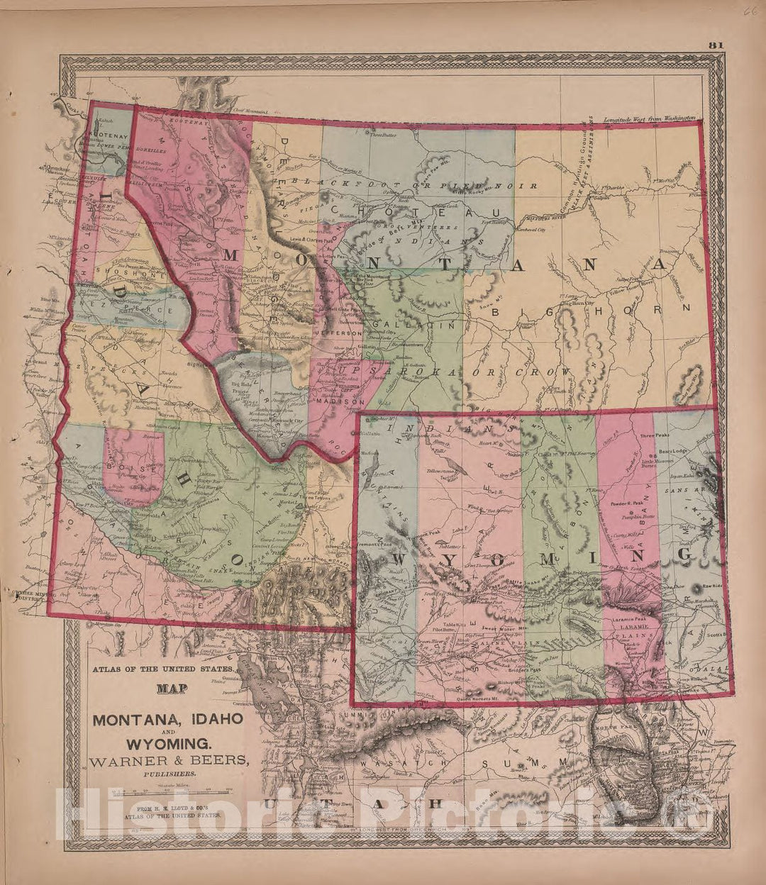
Historic 1870 Map - Atlas of Marshall Co. and The State of Illinois - Map of Montana, Idaho, and Wyoming, Warner and Beers - Atlas of Marshall County and The State of Illinois

Atlas of Marshall Co. and the state of Illinois : to which is added an atlas of the United States, maps of the hemispheres &c. &c. &c.We print high quality...
From: $49.99

Historic Map - The United States of America [Wyoming attached to Dakota], 1865, Joseph Hutchins Colton - Vintage Wall Art

The United States of America [Wyoming attached to Dakota], 1865, Joseph Hutchins Colton
From: $49.99

Historic Map - The United States of America [Wyoming attached to Dakota], 1866, G.W. & C.B. Colton - Vintage Wall Art

The United States of America [Wyoming attached to Dakota], 1866, G.W. & C.B. ColtonWe print high quality reproductions of historical maps, photographs, prints, etc. Because of their historical nature, some...
From: $49.99

Historic Map - Map Showing Location of Sheridan, Wyoming and Surrounding Reservations, 1898, United States GPO - Vintage Wall Art

Map Showing Location of Sheridan, Wyoming and Surrounding Reservations, 1898, United States GPOWe print high quality reproductions of historical maps, photographs, prints, etc. Because of their historical nature, some of...
From: $49.99

Historic Map - State of Wyoming, 1892, General Land Office v2

State of Wyoming , 1892, General Land OfficeWe print high quality reproductions of historical maps, photographs, prints, etc. Because of their historical nature, some of these images may show signs...
From: $49.99

Historic Map - State of Wyoming, 1892, General Land Office v1

State of Wyoming , 1892, General Land OfficeWe print high quality reproductions of historical maps, photographs, prints, etc. Because of their historical nature, some of these images may show signs...
From: $49.99

Historic Map : Map of the United States And Territories, Together with Canada &c. (Wyoming Territory delineated, but "Attached to Dacotah"), 1865, , Vintage Wall Art

Map of the United States And Territories, Together with Canada &c. (Wyoming Territory delineated, but "Attached to Dacotah"), 1865,
From: $49.99

Historic Map : Berta and Elmer Hader's Picture Book of The States. Colorado. Wyoming, 1932 Atlas - Vintage Wall Art

Berta and Elmer Hader's Picture Book of The States. Colorado. Wyoming, 1932 Atlas
From: $49.99

Historic Map : State Atlas Map, Wyoming, Livingston, Orleans, Genesee, Monroe counties. 1895 - Vintage Wall Art

Wyoming and Livingston counties. Orleans, Genesee and Monroe counties. Copyright 1895, Julius Bien & Company, N.Y. | Atlas of the state of New York. Prepared under the direction of Joseph...
From: $49.99

Historic Map - Map of The State of Wyoming, 1900 v1

Department Of The Interior General Land Office Hon. Binger Hermann, Commissioner. Map Of The State Of Wyoming. Compiled from the official Records of the General Land Office and other sources...
From: $34.99

Historic Map : Map of The State of Wyoming, 1900 v2

Department Of The Interior General Land Office Hon. Binger Hermann, Commissioner. Map Of The State Of Wyoming. Compiled from the official Records of the General Land Office and other sources...
From: $49.99

Historic Map : Department of The Interior General Land office Map - State of Wyoming, 1907 1907 - Vintage Wall Art

Department Of The Interior General Land Office Richard A. Ballinger, Commissioner. State Of Wyoming. Compiled from the official Records of the General Land Office and other sources, under the direction...
From: $49.99

Historic Map : Department of The Interior General Land office Map - State of Wyoming, 1912 1912 - Vintage Wall Art

Department Of The Interior General Land Office Fred Dennett, Commissioner. State Of Wyoming. Compiled from the official Records of the General Land Office and other sources, under the direction of...
From: $49.99

Historical Map, 1895 Post Route map of The States of Montana, Idaho and Wyoming with Adjacent Parts of N. & S. Dakota, Nebraska, Colorado, Utah, Nevada, Oregon, Vintage Wall Art

Post route map of the states of Montana, Idaho and Wyoming with adjacent parts of N. & S. Dakota, Nebraska, Colorado, Utah, Nevada, Oregon, and Washington showing post offices with...
From: $49.99

Historical Map, 1891 Post Route map of The States of North and South Dakota with Adjacent Parts of Montana, Wyoming, Nebraska, Iowa and Minnesota, Vintage Wall Art

Post route map of the states of North and South Dakota with adjacent parts of Montana, Wyoming, Nebraska, Iowa and Minnesota and portions of the Dominion of Canada : showing...
From: $49.99

Historical Map, 1895 Post Route map of The States of North and South Dakota with Adjacent Parts of Montana, Wyoming, Nebraska, Iowa and Minnesota, Vintage Wall Art

Post route map of the states of North and South Dakota with adjacent parts of Montana, Wyoming, Nebraska, Iowa and Minnesota and portions of the Dominion of Canada : showing...
From: $49.99

Historical Map, 1891 Post Route map of The States of Montana, Idaho and Wyoming with Adjacent Parts of N. & S. Dakota, Nebraska, Colorado, Utah, Nevada, Oregon, Vintage Wall Art

Post route map of the states of Montana, Idaho and Wyoming with adjacent parts of N. & S. Dakota, Nebraska, Colorado, Utah, Nevada, Oregon, and Washington showing post offices with...
From: $49.99

Historic Map : Wyoming and The State's Highways, Julius Muller, 1932, Vintage Wall Art

Wyoming and The State's Highways, Julius Muller, 1932
From: $49.99

Historic Map : The United States - First Map to show Wyoming Territory, Mitchell, 1865, Vintage Wall Art

The United States - First Map to show Wyoming Territory, Mitchell, 1865
From: $49.99
Showing products 1 - 33 of 33

Free Shipping

We offer Free Standard Shipping for all orders within the United States. If you want your stuff there faster, see Expedited and Overnight shipping cost at checkout.

Our Guarantee

If you are not completely satisfied, just send the product back to us and we'll replace it with another one of your choice OR refund your purchase price 100%. Our address is on the contact us page.

100% Satisfaction

We painstakingly labor over the preparation and printing of each individual product we sell. We stand behind the materials and workmanship, and want nothing more than for you to be 100% happy with your order.

Just added to your wishlist:
My Wishlist
Just added to your cart:
My Cart