-
-


-
Wall Color
in
Uncheck to hide the white line Check to show the white line -
-
.


Frame
Room
Gallery
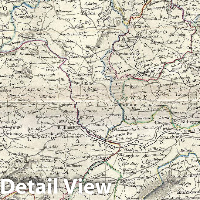
Historic Map : Black Map of Ireland in Counties, 1844, Vintage Wall Art
Historic Map : Black Map of Ireland in Counties, 1844, Vintage Wall Art
Note: Sold out or unavailable
Couldn't load pickup availability
This is a fine example of Adam and Charles Black's 1844 map of Ireland. It covers from Donegal in the north to Cork in the south. The map shows all of Ireland divided by county. After the Norman Invasion the old provincial structure was supplemented with modern system of counties – even so the old provinces are still referenced today. Various important cities, rivers, islands, mountain ranges, and several other topographical details are noted with relief shown by hachure.
In 1801, the island of Ireland became part of the United Kingdom of Great Britain and Ireland. Though Britain was flourished during this period, Ireland would witness the Great Irish Famine from 1845-1849 causing mass starvation and emigration and killing about a million people. As a result Ireland would experience a widespread exodus – mostly to the United States. By the end of the 19th century, almost 50% of immigrants into the United States would be from Ireland.
This map was engraved by S. Hall for issue as plate nos. in xII and in xIII in the 1844 edition of Black's General Atlas.
- MUSEUM QUALITY INKS AND PAPER: Printed on thick 192gsm heavyweight matte paper with archival giclee inks, this historic fine art will decorate your wall for years to come.
- VINTAGE MAP REPRODUCTION: Add style to any room's decor with this beautiful print. Whether your interior design is modern or classic, a map is never out of fashion.
- ATTENTION TO DETAIL: We edit every antique map for image quality, color and vibrance, so it can look its best while retaining historical character. Makes a great gift!
- FRAME READY: Your unframed poster will arrive crease-free, rolled in a sturdy mailing tube. Many maps fit easy-to-find standard size frames 16x20, 16x24, 18x24, 24x30, 24x36, saving on custom framing.
- Watermarks will not appear in the printed picture. Some blemishes, tears, or stamps may be removed from the final print.
Why choose Historic Pictoric
Every artwork we offer is carefully edited by our small but dedicated team of image professionals, ensuring each detail is perfect. We print every order to demand right here in the USA, treating every piece with the same care and attention we would give our own work. From editing to printing to packaging, we take pride in delivering artwork that meets our high standards—and we love knowing it’s heading to a home where it will be appreciated.
- Choosing a selection results in a full page refresh.
- Opens in a new window.