-
-


-
Wall Color
in
Uncheck to hide the white line Check to show the white line -
-
.


Frame
Room
Gallery
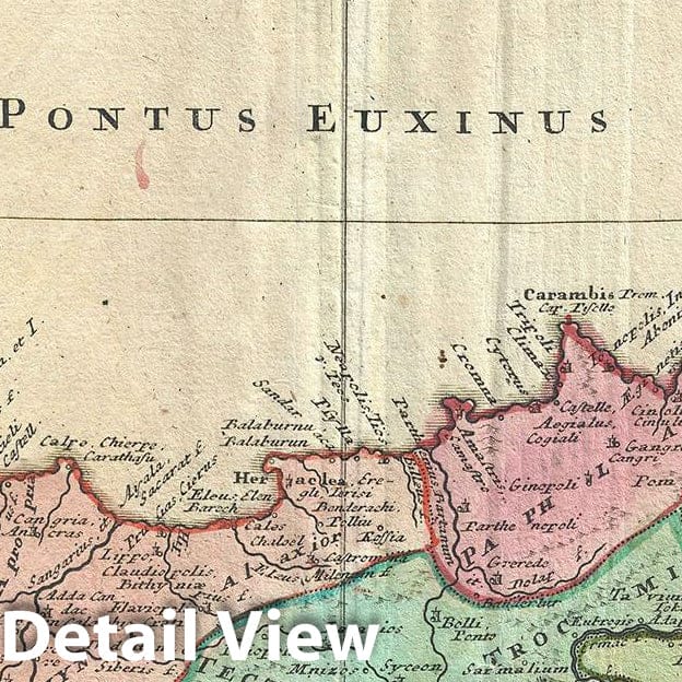
Historic Map : Homann Heirs Antique Map of Black Sea and Vicinity (Turkey, Asia Minor, Greece, Crimea), 1743, Vintage Wall Art
Historic Map : Homann Heirs Antique Map of Black Sea and Vicinity (Turkey, Asia Minor, Greece, Crimea), 1743, Vintage Wall Art
Note: Sold out or unavailable
Couldn't load pickup availability
This is an attractive 1743 map of Asia Minor by the Homann Heirs. The map depicts Turkey and the regions surrounding the Black Sea including parts of modern day Crimea, Romania, Russia, Ukraine, Georgia and Greece. Centered on the Black Sea, extends south to Cyprus and Crete and north to include the Sea of Azov. Notes the ancient Kingdoms of Asia Minor, many of which were Greek colonies or heavily influenced by Greek culture. These include Mysia, Lycia, Pisidia, Cilicia, Phrygia, Pontus, Lydia, Caria, Thynia, Phrygia Minor, Cappadocia, Armenia Minor, etc.
This region saw the development of currency, the conquest of Troy as well as the construction of three of the Ancient World's Seven Wonders. Highly detailed, it notes important cities rivers, mountains and a host of other topographical features. A large decorative cartouche in the upper left quadrant includes a description with illustrations of a temple, two warriors and other medieval and classical accents.
This map was drawn by Johann Matthias Haas and issued by Homann Heirs in 1743.
- MUSEUM QUALITY INKS AND PAPER: Printed on thick 192gsm heavyweight matte paper with archival giclee inks, this historic fine art will decorate your wall for years to come.
- VINTAGE MAP REPRODUCTION: Add style to any room's decor with this beautiful print. Whether your interior design is modern or classic, a map is never out of fashion.
- ATTENTION TO DETAIL: We edit every antique map for image quality, color and vibrance, so it can look its best while retaining historical character. Makes a great gift!
- FRAME READY: Your unframed poster will arrive crease-free, rolled in a sturdy mailing tube. Many maps fit easy-to-find standard size frames 16x20, 16x24, 18x24, 24x30, 24x36, saving on custom framing.
- Watermarks will not appear in the printed picture. Some blemishes, tears, or stamps may be removed from the final print.
Why choose Historic Pictoric
Every artwork we offer is carefully edited by our small but dedicated team of image professionals, ensuring each detail is perfect. We print every order to demand right here in the USA, treating every piece with the same care and attention we would give our own work. From editing to printing to packaging, we take pride in delivering artwork that meets our high standards—and we love knowing it’s heading to a home where it will be appreciated.
- Choosing a selection results in a full page refresh.
- Opens in a new window.