-
-


-
Wall Color
in
Uncheck to hide the white line Check to show the white line -
-


 Frame
Frame Room
Room Gallery
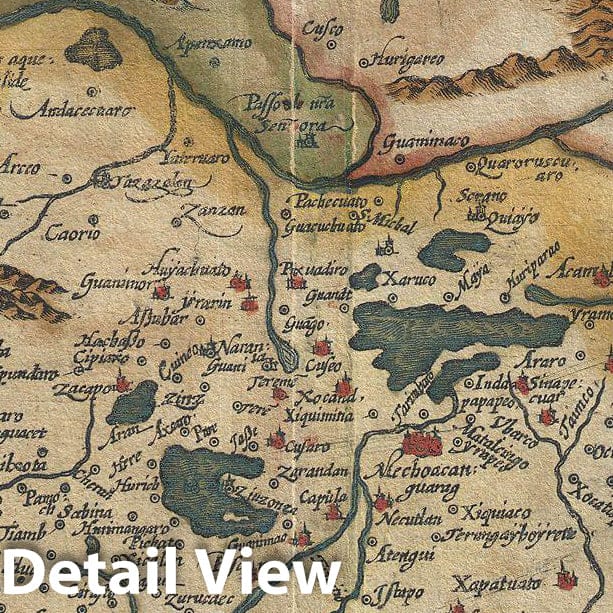
Historic Map : Hondius and Mercator Map of Mexico, 1606, Vintage Wall Art
Historic Map : Hondius and Mercator Map of Mexico, 1606, Vintage Wall Art
Note: Sold out or unavailable
Couldn't load pickup availability
This is a rare and often under appreciated 1606 mapping New Spain by Hondius and Mercator. Covering the viceroyalty granted to Hernan Cortez following his conquest of the Aztec Empire, this map details, roughly, from Mexico City westward to the Pacific coast and northward as far as modern day Michoacán. Cartographically Mercator's map is heavily influenced by Ortelius' 1579 map of the same region. Though we are uncertain of Ortelius' sources, this map exhibits a combination of known and speculative cartographic elements. Mexico City appears at right center surrounded by water as it appeared at the time of the conquest. By the time this map was drawn, much of the region between Mexico City and the Pacific ports along the coast, as well as the mining regions to the north and west, had been roughly mapped by the conquistadores. Lake Chapala (Chapalicum Mare) for example is accurately situated and formed. However, as the map extends further north into only tenuously explored regions, the cartography becomes more speculative. The large inland sea in the northwestern quadrant with is four numbered and named islands is clearly drawn from indigenous legends, most likely as transmitted via the Codex Mendoza. Elaborate baroque title cartouche in the upper right quadrant.
- VINTAGE MAP REPRODUCTION: Add style to any room's decor with this beautiful decorative print. Whether your interior design is modern, rustic or classic, a map is never out of fashion
- MUSEUM QUALITY INKS AND PAPER: Printed on thick 192gsm heavyweight matte paper with archival giclee inks, this historic fine art will decorate your wall for years to come
- ARTWORK MADE TO ORDER IN THE USA: We make each reprint only when you order it. Every antique map is edited for image quality, color and vibrance, so it can look its best while retaining historical character. Makes a great gift!
- FRAME READY: Your unframed poster ships crease-free, rolled in a sturdy mailing tube. Many maps fit easy-to-find standard size frames 16x20, 16x24, 18x24, 24x30, 24x36, saving on custom framing
- Watermarks will not appear in the printed picture. Old maps sometimes have blemishes, tears, or stamps that may be removed from the final print
Why choose Historic Pictoric
Every artwork we offer is carefully edited by our small but dedicated team of image professionals, ensuring each detail is perfect. We print every order to demand right here in the USA, treating every piece with the same care and attention we would give our own work. From editing to printing to packaging, we take pride in delivering artwork that meets our high standards—and we love knowing it’s heading to a home where it will be appreciated.