-
-


-
Wall Color
in
Uncheck to hide the white line Check to show the white line -
-
-


 Frame
Frame Room
Room Gallery
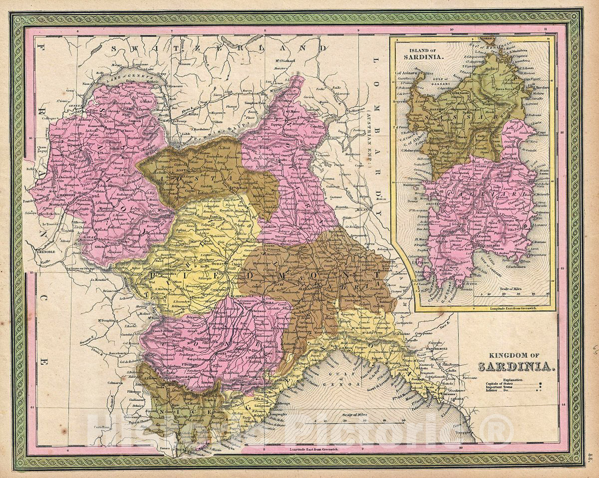
Historic Map : Mitchell Map of Italy: Kingdom of Sardinia and Piedmont, 1849, Vintage Wall Art
Historic Map : Mitchell Map of Italy: Kingdom of Sardinia and Piedmont, 1849, Vintage Wall Art
Note: Sold out or unavailable
Couldn't load pickup availability
This is a fine example of Thomas Cowperthwait and S. A. Mitchell's 1849 map of Kingdom of Sardinia. Centered in Piedmont, this map covers the Kingdom of Sardinia's claims both on the Island of Sardinia and the mainland provinces of Piedmont, Savoy, Aosta, Coni, Nice, and Genoa. The whole is engraved in Mitchell's distinctive style with green border work and vivid pastels. Political and topographical features are noted and color coded with elevation rendered by hachure.
The Kingdom of Sardinia or Piedmont-Sardinia was ruled by the House of Savoy since 1720, barring a short period when the mainland domains were annexed by Napoleonic France. The Congress of Vienna however returned these territories to the House of Savoy in 1814 with the inclusion of Genoa. In 1848, just a year before this map was made, King Charles Albert proposed a new constitution, which would eventually become the constitution of the unified Kingdom of Italy in 1861. The region would also be on the brink of the Crimean War (1853 – 1856), a conflict between the Kingdom of Sardinia along with the allied forces of the British, French and Ottoman Empires against the Russian Empire.
This map was prepared by S. A. Mitchell for publication by the Philadelphia firm of Thomas Cowperthwait & Co. as plate no. 55 in the 1849 edition of Mitchell's New General Atlas.
- VINTAGE MAP REPRODUCTION: Add style to any room's decor with this beautiful decorative print. Whether your interior design is modern, rustic or classic, a map is never out of fashion
- MUSEUM QUALITY INKS AND PAPER: Printed on thick 192gsm heavyweight matte paper with archival giclee inks, this historic fine art will decorate your wall for years to come
- ARTWORK MADE TO ORDER IN THE USA: We make each reprint only when you order it. Every antique map is edited for image quality, color and vibrance, so it can look its best while retaining historical character. Makes a great gift!
- FRAME READY: Your unframed poster ships crease-free, rolled in a sturdy mailing tube. Many maps fit easy-to-find standard size frames 16x20, 16x24, 18x24, 24x30, 24x36, saving on custom framing
- Watermarks will not appear in the printed picture. Old maps sometimes have blemishes, tears, or stamps that may be removed from the final print
Why choose Historic Pictoric
Every artwork we offer is carefully edited by our small but dedicated team of image professionals, ensuring each detail is perfect. We print every order to demand right here in the USA, treating every piece with the same care and attention we would give our own work. From editing to printing to packaging, we take pride in delivering artwork that meets our high standards—and we love knowing it’s heading to a home where it will be appreciated. What our customers say.