-
-


-
Wall Color
in
Uncheck to hide the white line Check to show the white line -
-
.


Frame
Room
Gallery
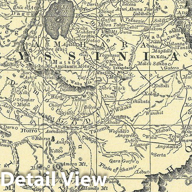
Historic Map : Rand McNally Antique Map of Abyssinia (Ethiopia), 1892, Vintage Wall Art
Historic Map : Rand McNally Antique Map of Abyssinia (Ethiopia), 1892, Vintage Wall Art
Note: Sold out or unavailable
Couldn't load pickup availability
This is a beautiful example of Rand McNally and Company's 1892 map of Abyssinia (Ethiopia) and surrounding countries. It covers from El Mekheir (Berber) to Zooay Lake. This map was made during the last year of the Great Ethiopian Famine, which killed around a third of its population and lasted from 1888 to 1892. This map of Abyssinia and surround countries, printed on half the page unlike most other maps in this atlas, contains a list of divisions, lakes, mountains, rivers and towns in the lower half of the page, on the left of the printed map. Color coded according to regions, the map notes several towns, cities, rivers, mountains, and various other topographical details with relief shown by hachure. This map was issued as plate no. 549 in the 1893 issue of Rand McNally and Company's Indexed Atlas of the World - possibly the finest atlas Rand McNally ever issued.
- VINTAGE MAP REPRODUCTION: Add style to any room's decor with this beautiful decorative print. Whether your interior design is modern, rustic or classic, a map is never out of fashion
- MUSEUM QUALITY INKS AND PAPER: Printed on thick 192gsm heavyweight matte paper with archival giclee inks, this historic fine art will decorate your wall for years to come
- ARTWORK MADE TO ORDER IN THE USA: We make each reprint only when you order it. Every antique map is edited for image quality, color and vibrance, so it can look its best while retaining historical character. Makes a great gift!
- FRAME READY: Your unframed poster ships crease-free, rolled in a sturdy mailing tube. Many maps fit easy-to-find standard size frames 16x20, 16x24, 18x24, 24x30, 24x36, saving on custom framing
- Watermarks will not appear in the printed picture. Old maps sometimes have blemishes, tears, or stamps that may be removed from the final print
Why choose Historic Pictoric
Every artwork we offer is carefully edited by our small but dedicated team of image professionals, ensuring each detail is perfect. We print every order to demand right here in the USA, treating every piece with the same care and attention we would give our own work. From editing to printing to packaging, we take pride in delivering artwork that meets our high standards—and we love knowing it’s heading to a home where it will be appreciated.