-
-


-
Wall Color
in
Uncheck to hide the white line Check to show the white line -
-
.


Frame
Room
Gallery
Historic Map : Read Map of Saint Helena Island (Napoleon in Exile), 1815, Vintage Wall Art
Historic Map : Read Map of Saint Helena Island (Napoleon in Exile), 1815, Vintage Wall Art
Note: Sold out or unavailable
Couldn't load pickup availability
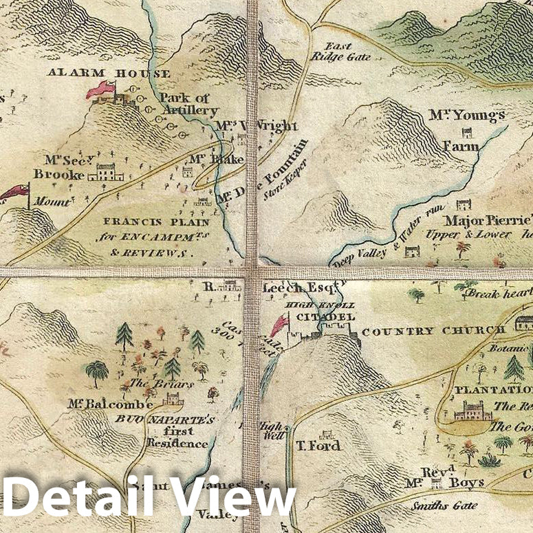
A remarkable 1815 map of the Island of Saint Helena, the fallen Emperor Napoleon Buonaparte's final place of exile, by Robert P. Read. After his June 18, 1815 defeat at the Battle of Waterloo, Napoleon sought asylum from the British who promptly exiled him to the island of Saint Helena. Although despised by much of Europe, Napoleon also inspired admiration as the ultimate romantic hero – a persecuted, lonely, misunderstood genius. The English poet Lord Byron immortalized this popular conception of the exiled emperor in his Ode to Napoleon Buonaparte. This map was issued to capitalize on and satisfy this broad public interest in Buonaparte.
The map is beautifully executed. Oriented to the southeast, it portrays the remote Atlantic islands as a veritable fortress, surrounded by sheer mountains and reinforced by strategically placed cannon batteries, and British Royal Navy vessels patrolling the sea. The interior of the island, by contrast, is illustrated by verdant greenery, country farms, and gentlemanly estates – very much in the mold of the pleasant English countryside and an appropriate resting place for the romantic emperor's exile. Bonaparte's home one the island was Longwood, appearing here in the lower left quadrant of the island. The image suggests a lordly multistory mansion set in a bucolic forest. The residence was, in fact, the run down summer residence of the island's governor, which, although large, suffered from a brutally cold damp climate, and was, in any case, a far cry from Versailles. The site of Napoleon's tomb on the island, not far from Longwood, is identified in manuscript.
In the lower right corner of the map there are facsimiles of Napoleon's signature, first when First Consul, and another when Emperor. There is a manuscript signature in the right margin of the map identifying the original owner, one Andrew Bloram, of which we have been able to glean little.
- MUSEUM QUALITY INKS AND PAPER: Printed on thick 192gsm heavyweight matte paper with archival giclee inks, this historic fine art will decorate your wall for years to come.
- VINTAGE MAP REPRODUCTION: Add style to any room's decor with this beautiful print. Whether your interior design is modern or classic, a map is never out of fashion.
- ATTENTION TO DETAIL: We edit every antique map for image quality, color and vibrance, so it can look its best while retaining historical character. Makes a great gift!
- FRAME READY: Your unframed poster will arrive crease-free, rolled in a sturdy mailing tube. Many maps fit easy-to-find standard size frames 16x20, 16x24, 18x24, 24x30, 24x36, saving on custom framing.
- Watermarks will not appear in the printed picture. Some blemishes, tears, or stamps may be removed from the final print.
Why choose Historic Pictoric
Every artwork we offer is carefully edited by our small but dedicated team of image professionals, ensuring each detail is perfect. We print every order to demand right here in the USA, treating every piece with the same care and attention we would give our own work. From editing to printing to packaging, we take pride in delivering artwork that meets our high standards—and we love knowing it’s heading to a home where it will be appreciated.
- Choosing a selection results in a full page refresh.
- Opens in a new window.