-
-


-
Wall Color
in
Uncheck to hide the white line Check to show the white line -
-
.


Frame
Room
Gallery
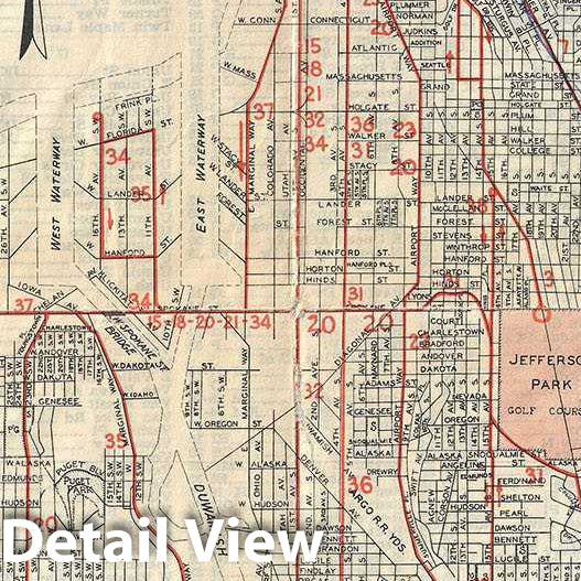
Historic Map : Smith Antique Map or Plan of Seattle, Washington, 1948, Vintage Wall Art
Historic Map : Smith Antique Map or Plan of Seattle, Washington, 1948, Vintage Wall Art
Note: Sold out or unavailable
Couldn't load pickup availability
This is a detailed city plan of Seattle dating to 1948. The map, drawn by Irving M. Smith covers the city of Seattle from 98th street south to SW 132nd street. Notes individual streets, parks, golf courses, lakes, bridges, playgrounds, rivers and harbor and shorelines. Bus lines are noted in red. An inset showing the system of street designations is included in the lower left quadrant. In the bottom portion of the sheet, below the map proper, another inset depicts the postal sections. A short paragraph provides important information about Seattle. This map was issued to accompany the Seattle Map and City Guide published in 1949 - the ‘only book of its kind published in Seattle'. The guidebook provides important tourist information including a street index, hotels, clubs, schools, beaches etc. The map and guide were published by Newman-Burrows Co., Inc.
- MUSEUM QUALITY INKS AND PAPER: Printed on thick 192gsm heavyweight matte paper with archival giclee inks, this historic fine art will decorate your wall for years to come.
- VINTAGE MAP REPRODUCTION: Add style to any room's decor with this beautiful print. Whether your interior design is modern or classic, a map is never out of fashion.
- ATTENTION TO DETAIL: We edit every antique map for image quality, color and vibrance, so it can look its best while retaining historical character. Makes a great gift!
- FRAME READY: Your unframed poster will arrive crease-free, rolled in a sturdy mailing tube. Many maps fit easy-to-find standard size frames 16x20, 16x24, 18x24, 24x30, 24x36, saving on custom framing.
- Watermarks will not appear in the printed picture. Some blemishes, tears, or stamps may be removed from the final print.
Why choose Historic Pictoric
Every artwork we offer is carefully edited by our small but dedicated team of image professionals, ensuring each detail is perfect. We print every order to demand right here in the USA, treating every piece with the same care and attention we would give our own work. From editing to printing to packaging, we take pride in delivering artwork that meets our high standards—and we love knowing it’s heading to a home where it will be appreciated.
- Choosing a selection results in a full page refresh.
- Opens in a new window.