-
-


-
Wall Color
in
Uncheck to hide the white line Check to show the white line -
-
.


Frame
Room
Gallery
Historic Map : Map of The Surveyed Part of Michigan, 1837 - Vintage Wall Art
Historic Map : Map of The Surveyed Part of Michigan, 1837 - Vintage Wall Art
Note: Sold out or unavailable
Couldn't load pickup availability
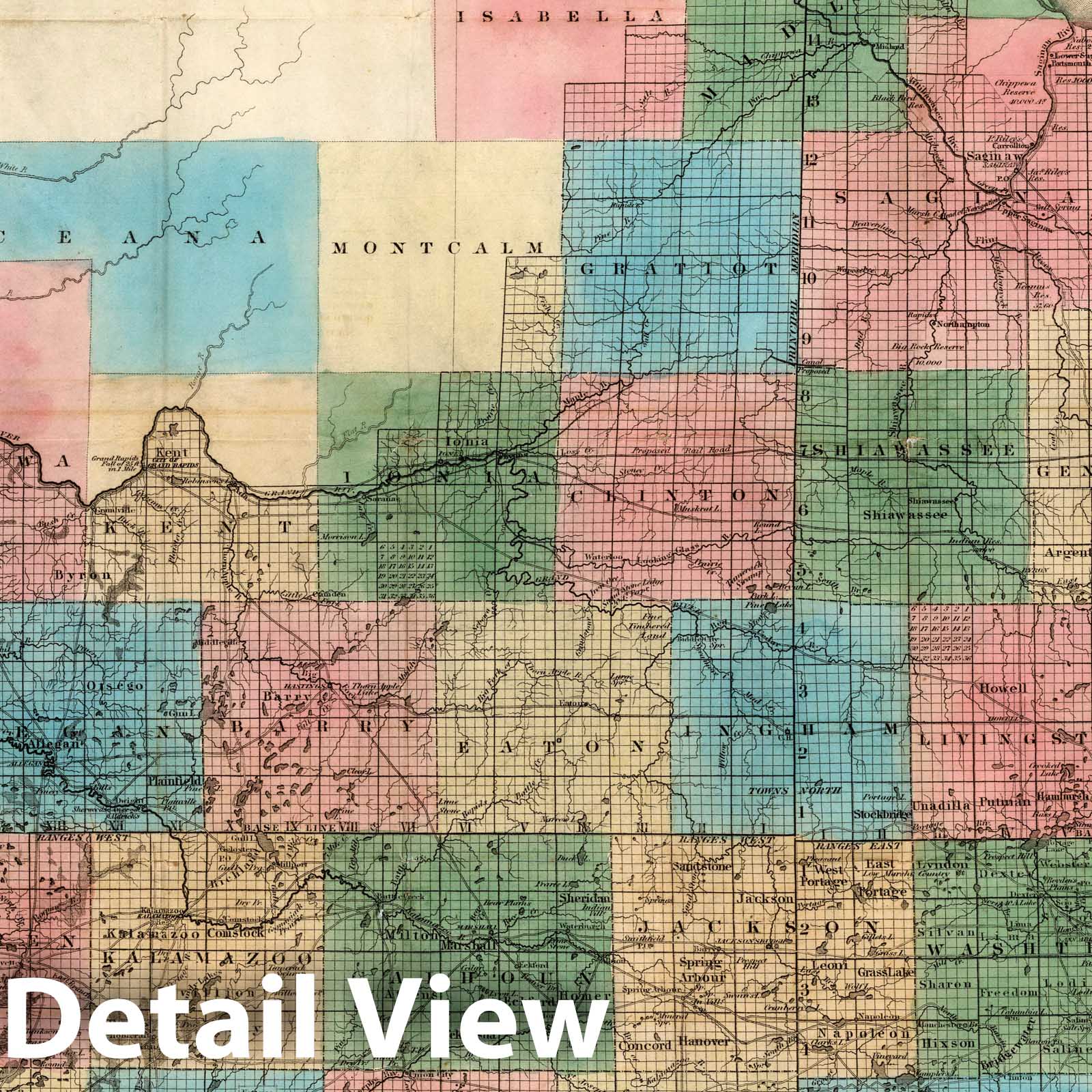
Map Of The Surveyed Part Of Michigan, By John Farmer. Published by J.H. Colton & Co. New-York. 1837. Engraved by S. Stiles & Co. New-York. Entered ... 1836, by J.H. Colton & Co ... New York. (inset) The Unsurveyed Part Of Michigan. (inset) Map Of The Straits Of Mackinaw. From Actual Survey. (inset) Map Of Mackinaw Isle. | Map Of The Surveyed Part Of Michigan, By John Farmer. Published by J.H. Colton & Co. New-York. 1837. Engraved by S. Stiles & Co. New-York. Entered ... 1836, by J.H. Colton & Co ... New York. (inset) The Unsurveyed Part Of Michigan. (inset) Map Of The Straits Of Mackinaw. From Actual Survey. (inset) Map Of Mackinaw Isle. | 1st issue, later issues to 1855. Farmer sold his map copyrights to Colton in 1835, and this is the first issue of the "new" Farmer map by Colton, also probably one of the first maps of Michigan as a state. It is copyright 1836, but 1837 was the first issue. Colton also issued in 1837 another Farmer map he acquired - "Map of the State of Michigan and Territory of Wisconsin..." which was copyright in 1835 (Karpinski 140). The text on the inside of the front cover refers to Michigan as a Territory, so this map may be transitional from territory to state. The township and range lines are prominent on the map, and the text on the inside front cover tells us how to find our way if "totally lost" using these lines. Full color. Map is folded into stamped red leather covers 14.5x9 with "Farmer's Map Of Michigan Exhibiting The Sections" in gilt.
We print high quality reproductions of historical maps, photographs, prints, etc. Because of their historical nature, some of these images may show signs of wear and tear - small rips, stains, creases, etc. We believe that in many cases this contributes to the historical character of the item.
- VINTAGE MAP REPRODUCTION: Add style to any room's decor with this beautiful decorative print. Whether your interior design is modern, rustic or classic, a map is never out of fashion
- MUSEUM QUALITY INKS AND PAPER: Printed on thick 192gsm heavyweight matte paper with archival giclee inks, this historic fine art will decorate your wall for years to come
- ARTWORK MADE TO ORDER IN THE USA: We make each reprint only when you order it. Every antique map is edited for image quality, color and vibrance, so it can look its best while retaining historical character. Makes a great gift!
- FRAME READY: Your unframed poster ships crease-free, rolled in a sturdy mailing tube. Many maps fit easy-to-find standard size frames 16x20, 16x24, 18x24, 24x30, 24x36, saving on custom framing
- Watermarks will not appear in the printed picture. Old maps sometimes have blemishes, tears, or stamps that may be removed from the final print
Why choose Historic Pictoric
Every artwork we offer is carefully edited by our small but dedicated team of image professionals, ensuring each detail is perfect. We print every order to demand right here in the USA, treating every piece with the same care and attention we would give our own work. From editing to printing to packaging, we take pride in delivering artwork that meets our high standards—and we love knowing it’s heading to a home where it will be appreciated.