-
-


-
Wall Color
in
Uncheck to hide the white line Check to show the white line -
-


 Frame
Frame Room
Room Gallery
Historic Map : U.S. Coast Survey Map of Eastern Long Island (Hamptons, Amagansett), 1857, Vintage Wall Art
Historic Map : U.S. Coast Survey Map of Eastern Long Island (Hamptons, Amagansett), 1857, Vintage Wall Art
Note: Sold out or unavailable
Couldn't load pickup availability
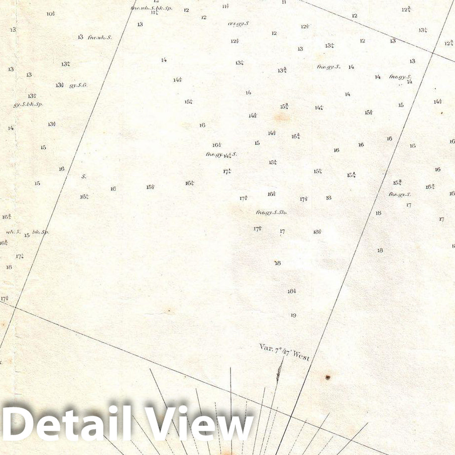
This is an extraordinary and extremely rare hand colored large format 1857 U.S. Coast Survey sea chart or map depicting southeastern Long Island, New York. Details part of Suffolk County from Moriches Bay to Napeague Harbor, including the summer getaways of Sag Harbor, East Hampton, Southampton (South Hampton), Quogue, Bridgehampton and Amagansett, among others. Extends as far north as Gardiner's Island and Hog Neck. Inland regions are depicted in considerable detail, down to individual buildings. In addition to inland details, this chart contains a wealth of practical information for the mariner from oceanic depths, to harbors and navigation tips on important channels. Two views decorate the bottom of the map, one depicting about 9 miles of coast south of Speonk, and another depicting the coast south of Shinnecock. The hand color work on this beautiful map is exceptionally well done. This map was created under the direction of A. D. Bache, Superintendent of the Survey of the Coast of the United States and one of the most influential American cartographers of the 19th century. This is one of the rarest coast chart's out there and one of the best maps of Long Island to appear in the 19th century.
- VINTAGE MAP REPRODUCTION: Add style to any room's decor with this beautiful decorative print. Whether your interior design is modern, rustic or classic, a map is never out of fashion
- MUSEUM QUALITY INKS AND PAPER: Printed on thick 192gsm heavyweight matte paper with archival giclee inks, this historic fine art will decorate your wall for years to come
- ARTWORK MADE TO ORDER IN THE USA: We make each reprint only when you order it. Every antique map is edited for image quality, color and vibrance, so it can look its best while retaining historical character. Makes a great gift!
- FRAME READY: Your unframed poster ships crease-free, rolled in a sturdy mailing tube. Many maps fit easy-to-find standard size frames 16x20, 16x24, 18x24, 24x30, 24x36, saving on custom framing
- Watermarks will not appear in the printed picture. Old maps sometimes have blemishes, tears, or stamps that may be removed from the final print
Why choose Historic Pictoric
Every artwork we offer is carefully edited by our small but dedicated team of image professionals, ensuring each detail is perfect. We print every order to demand right here in the USA, treating every piece with the same care and attention we would give our own work. From editing to printing to packaging, we take pride in delivering artwork that meets our high standards—and we love knowing it’s heading to a home where it will be appreciated.