-
-


-
Wall Color
in
Uncheck to hide the white line Check to show the white line -
-
.
![Historical Map, 1850 [Map of The World on a polyconic Projection], Vintage Wall Art](//www.historicpictoric.com/cdn/shop/products/5133943_1wmark.jpg?v=1683492627&width=1946)

![Historical Map, 1850 [Map of The World on a polyconic Projection], Vintage Wall Art](http://www.historicpictoric.com/cdn/shop/products/5133943_1wmark.jpg?v=1683492627&width=1946)

Frame
Room
Gallery
Historical Map, 1850 [Map of The World on a polyconic Projection], Vintage Wall Art
Historical Map, 1850 [Map of The World on a polyconic Projection], Vintage Wall Art
Note: Sold out or unavailable
Couldn't load pickup availability
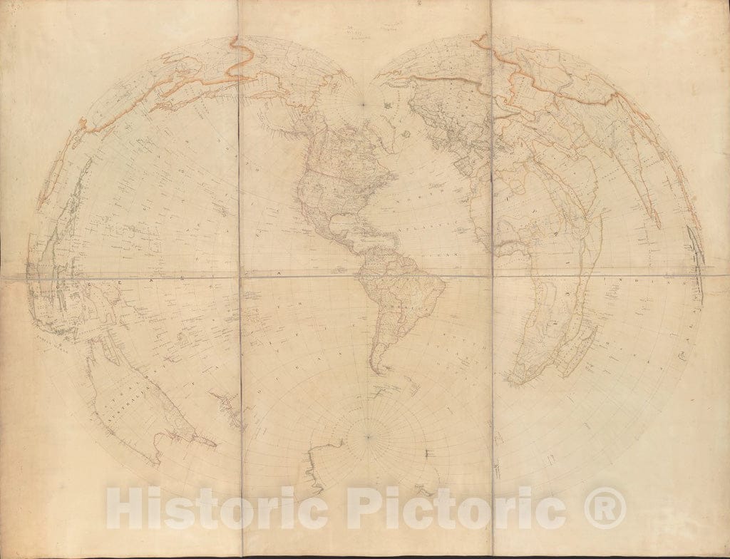
Not much is known about the creation of this untitled, unattributed, and undated manuscript map other than it was obviously drawn to illustrate the properties of a map projection that was first developed and used in the early to mid-19th century. This type of projection was originally proposed by Ferdinand Rudolph Hassler (1770-1843), the first director of the agency that came to be known as the U.S. Coast and Geodetic Survey. The construction of this projection is based on the theoretical application of many (poly) cones to the Earth's surface (a sphere), each touching a single line of latitude (or parallel) along which there is true scale (measurement of distance). When applied to the entire globe, this projection produces a symmetrical pattern of lines where the central meridian (longitude) and the Equator are straight lines. There is no distortion along the central meridian, but distortion becomes much greater as you move further to the east and west. This projection is best adapted to large-scale mapping of small areas. Consequently, it was commonly used by the Coast and Geodetic Survey from the mid-19th century for the next 100 years as the base for its coastal charts of American waters and by the U.S. Geological Survey for its topographic quadrangles from the end of the 19th century up to the 1950s. Since the central meridian of this particular example of the polyconic projection runs through Washington, D.C., it was likely created in conjunction with the mapping activities of a federal government agency, such as the Coast and Geodetic Survey.
- MUSEUM QUALITY INKS AND PAPER: Printed on thick 192gsm heavyweight matte paper with archival giclee inks, this historic fine art will decorate your wall for years to come.
- VINTAGE MAP REPRODUCTION: Add style to any room's decor with this beautiful print. Whether your interior design is modern or classic, a map is never out of fashion.
- ATTENTION TO DETAIL: We edit every antique map for image quality, color and vibrance, so it can look its best while retaining historical character. Makes a great gift!
- FRAME READY: Your unframed poster will arrive crease-free, rolled in a sturdy mailing tube. Many maps fit easy-to-find standard size frames 16x20, 16x24, 18x24, 24x30, 24x36, saving on custom framing.
- Watermarks will not appear in the printed picture. Some blemishes, tears, or stamps may be removed from the final print.
What our customers are saying
★★★★★I purchased an historic map, 16x24 inch. It is beautifully printed on heavy stock. The lettering, colors, and details of the map are crisp and easy to read. I am highly satisfied and would certainly purchase from Historic Pictoric again!
Kent A.
★★★★★Ordered the Pan American Midway print to fit a lovely thrift-store gilded frame. I love showing off Buffalo's rich history and this is a pretty entertaining photo from 1901. Prompt shipping. Sturdy packaging.
Cindy O.
★★★★★I received my print within days of ordering, and it arrived well packed in a mailing tube. The print is high quality and exactly as advertised. I will use Historic Pictoric again in the future!
Cheryl H.
★★★★★Excellent product. Great fidelity in reproduction of the original. Fine/minute details were sharp, colors were vibrant, and thickness, texture and overall feel and quality of the paper were excellent. Very satisfied with my purchase.
Konrad B.
★★★★★I have purchased six maps from Historic Pictoric. I find the quality to be excellent. Their customers service is also excellent. Outstanding! I called to exchange a few for different sizes and I could not have asked for a better experience.
Aaron C.
★★★★★The original map I ordered lacked some of the detail that I had hoped for, but they responded with several more map possibilities to choose from. Excellent service- a far step beyond what anyone expects from online purchases.
Dan M.
★★★★★I am a owner of 5 maps from Historic Pictoric. From Okinawa, 1945, Europe 1940-1945 battle maps. Now they’re helping me with the battle of Gettysburg. These maps are so much superior to the map on a page in a book. I have framed two of them.
Steven Ko
★★★★★Great heavy paper quality and clarity of my nautical map. Will be a great addition to our home close to the beach!
Jennifer A