-
-


-
Wall Color
in
Uncheck to hide the white line Check to show the white line -
-
.


Frame
Room
Gallery
Historic Map : Imray Antique Map Nautical Chart of The East Coast of The United States: New York to Florida, 1855, Vintage Wall Art
Historic Map : Imray Antique Map Nautical Chart of The East Coast of The United States: New York to Florida, 1855, Vintage Wall Art
Note: Sold out or unavailable
Couldn't load pickup availability
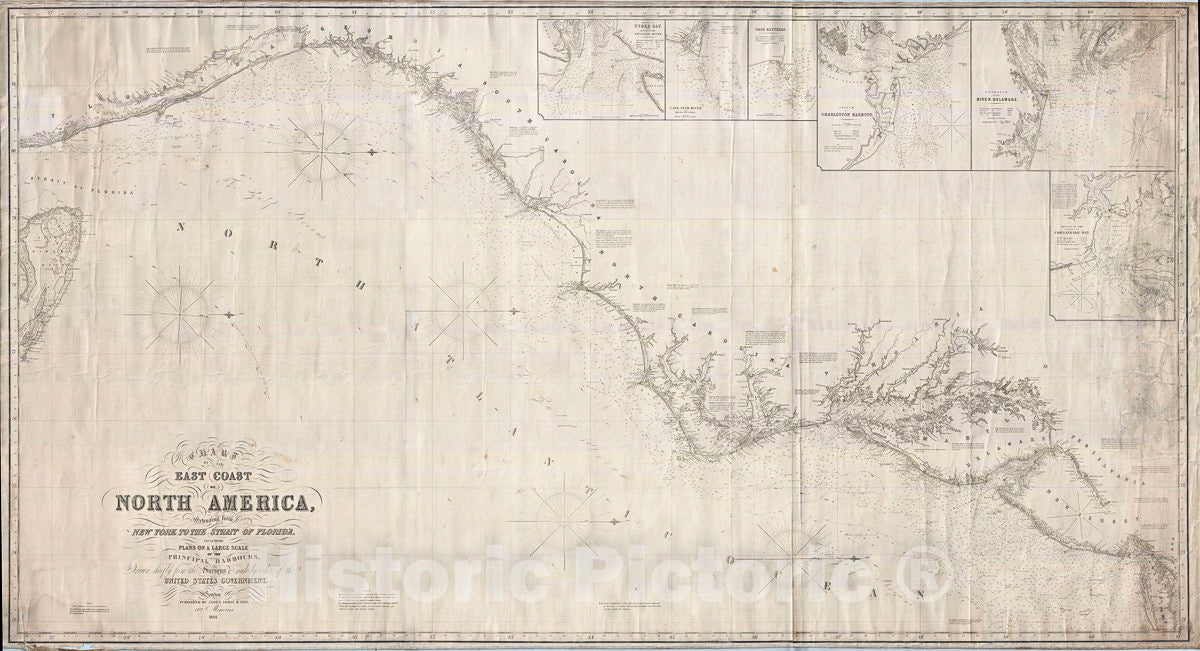
An extremely scarce, highly decorative, and monumentally proportioned 1855 sea chart or maritime map detailing the eastern coast of the United States from New York City to southern Florida (roughly around Palm Beach). The map was prepared by the British chart publisher James Imray and Son in their distinctive expansive style. In a broad spread, it includes the coasts of New York, New Jersey, Delaware, Maryland, Virginia, North Carolina, South Carolina, and Florida. The Chesapeake Bay, Delaware Bay, New York Harbor, the Bahama Banks, and the Outer Banks are rendered in beautiful detail. The chart is presented on a Mercator Projection with latitude measured from Greenwich, England. Like most nautical charts, the cartographer offers very little inland detail, but a wealth of maritime data. This includes the identification of various ports and harbors, coastal topography, shoals and other undersea dangers, and countless depth soundings in fathoms.
This chart further features siin x large insets in the upper right quadrant offering detailed charts of 'Tybee Bay and the Mouth of the Savannah River,' 'Cape Fear River and Frying-Pan Shoals,' 'Cape Hatteras,' 'Charleston Harbor,' the 'Entrance of the River Delaware,' and the 'Entrance to Chesapeake Bay.' The cartography of the insets generally follows the preliminary work of the U. S. Coast Survey in their respective regions.
This, like most maps published by James Imray before his death in 1870, this chart is extremely scarce with only two known examples appearing in institutional collections and none in private hands. James Imray's Son, James Frederick Imray, did publish a similar far more common chart, covering roughly the same region but following the minimalist stylistic conventions of the British Admiralty, in 1883.
- MUSEUM QUALITY INKS AND PAPER: Printed on thick 192gsm heavyweight matte paper with archival giclee inks, this historic fine art will decorate your wall for years to come.
- VINTAGE MAP REPRODUCTION: Add style to any room's decor with this beautiful print. Whether your interior design is modern or classic, a map is never out of fashion.
- ATTENTION TO DETAIL: We edit every antique map for image quality, color and vibrance, so it can look its best while retaining historical character. Makes a great gift!
- FRAME READY: Your unframed poster will arrive crease-free, rolled in a sturdy mailing tube. Many maps fit easy-to-find standard size frames 16x20, 16x24, 18x24, 24x30, 24x36, saving on custom framing.
- Watermarks will not appear in the printed picture. Some blemishes, tears, or stamps may be removed from the final print.
What our customers are saying
★★★★★I purchased an historic map, 16x24 inch. It is beautifully printed on heavy stock. The lettering, colors, and details of the map are crisp and easy to read. I am highly satisfied and would certainly purchase from Historic Pictoric again!
Kent A.
★★★★★Ordered the Pan American Midway print to fit a lovely thrift-store gilded frame. I love showing off Buffalo's rich history and this is a pretty entertaining photo from 1901. Prompt shipping. Sturdy packaging.
Cindy O.
★★★★★I received my print within days of ordering, and it arrived well packed in a mailing tube. The print is high quality and exactly as advertised. I will use Historic Pictoric again in the future!
Cheryl H.
★★★★★Excellent product. Great fidelity in reproduction of the original. Fine/minute details were sharp, colors were vibrant, and thickness, texture and overall feel and quality of the paper were excellent. Very satisfied with my purchase.
Konrad B.
★★★★★I have purchased six maps from Historic Pictoric. I find the quality to be excellent. Their customers service is also excellent. Outstanding! I called to exchange a few for different sizes and I could not have asked for a better experience.
Aaron C.
★★★★★The original map I ordered lacked some of the detail that I had hoped for, but they responded with several more map possibilities to choose from. Excellent service- a far step beyond what anyone expects from online purchases.
Dan M.
★★★★★I am a owner of 5 maps from Historic Pictoric. From Okinawa, 1945, Europe 1940-1945 battle maps. Now they’re helping me with the battle of Gettysburg. These maps are so much superior to the map on a page in a book. I have framed two of them.
Steven Ko
★★★★★Great heavy paper quality and clarity of my nautical map. Will be a great addition to our home close to the beach!
Jennifer A

