Skip to content
icon-X
Close menu
Maps
World Maps
World War 2 Maps
Pictorial Maps
USGS TopoGraphic Maps
Art Prints
Blueprints
Fine Art Museum Collections
Claude Monet
Photographs
Modern Photos
Posters
Collections
Kid's Room
Autos, Trains & Rails
Monet and Manet
Brewery, Beer, Liquor & more
Holiday Ready to Gift Products
Log in
Follow Us
instagram
Instagram
Facebook
twitter
Twitter
Maps
World Maps
World War 2 Maps
Pictorial Maps
USGS TopoGraphic Maps
Art Prints
Blueprints
Fine Art Museum Collections
Claude Monet
Photographs
Modern Photos
Posters
Collections
Kid's Room
Autos, Trains & Rails
Monet and Manet
Brewery, Beer, Liquor & more
Holiday Ready to Gift Products
account
Log in
icon-search
Search
icon-hamburger
Site navigation
icon-bag-minimal
Cart
Search
Search
Free economy shipping for unframed orders of $75 or more!
Filter
icon-X
Close menu
Lake Maps
icon-filter
Filter
Historic Map - Cartomap Leech Lake Minnesota Showing Leech Lake and Vicinity with Roads to Resorts and Historical Data Pertinent to the Lake, 1940 - Vintage Wall Art
From:
$49.99
Historic Map : Big Bear Lake California, Big Bear Lake Souvenir Fun Map, 1947, George Ramsey, Vintage Wall Art
From:
$39.99
Map : Rangeley Lakes, Maine, The Rangeley Lakes region, Maine , Antique Vintage Reproduction
From:
$49.99
Map : Geologic map of the Lake Superior region, Minnesota, Wisconsin and northern Michigan, bedrock geology, 1982 Cartography Wall Art :
From:
$49.99
Historic Map : Cartomap Leech Lake, Minnesota, 1940, Vintage Wall Decor
From:
$49.99
Historic Map : Rangeley, Rangeley Lakes Region 1963 , Vintage Wall Art
From:
$39.99
Historic Map - Beautiful Lake Vermillion, 1938, Frank Antoncich - Vintage Wall Art
From:
$49.99
Historic Map - Big Bear Lake VAlley, 1946, Monte R. Viceroy - Vintage Wall Art
From:
$49.99
Historic Map - A Romance Map of the Finger Lakes Region of Central New York, 1962 - Vintage Wall Art
From:
$49.99
Historic Map : Fishing Map Mammoth Lakes Region, ., 1930, Vintage Wall Art
From:
$49.99
Historic Map : Sebec Lake Maine, 1940 , Vintage Wall Art
From:
$34.99
Map : Geologic map of the Lake Tahoe basin, California and Nevada, 1:100,000 scale, 2005 Cartography Wall Art :
From:
$49.99
Historic Nautical Map - Lake Of The Woods, MN, 1985 NOAA Chart - Vintage Wall Art
From:
$49.99
Historic Nautical Map - Lake Michigan, 1939 NOAA Chart - Vintage Wall Art
From:
$49.99
Historic Map - Malverne And Lake View - Nassau County (N.Y.)- New York (State) - Nassau County - Vintage Wall Art
From:
$49.99
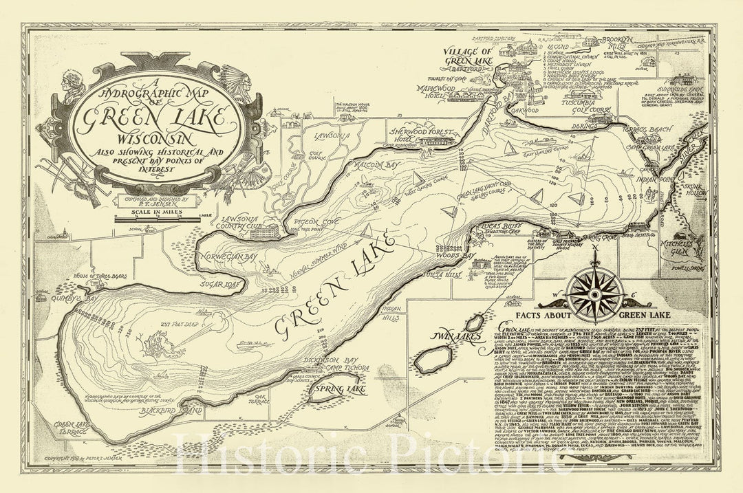
Historic Map : Green Lake, Wisconsin 1937, A hydrographic map of Green Lake, Wisconsin : also showing historical and present day points of interest , Antique Vintage Reproduction
From:
$49.99
Map : Hydrographic Map of the Oconomowoc-Waukesha Lake District, Waukesha County, Wisconsin, 1898 Cartography Wall Art :
From:
$49.99
Map : Geology and ground water in Russian River valley areas and in Round, Laytonville, and Little Lake Valleys, Sonoma and Mendocino Counties, California, 1965 Cartography Wall Art :
From:
$49.99
Map : Geology of the Fallen Leaf Lake 15' quadrangle, El Dorado County, California, 1983 Cartography Wall Art :
From:
$49.99
1
2
3
…
395
icon-chevron
Next
icon-X
"Close (esc)"
icon-chevron-left
icon-X
icon-chevron
icon-X
Lake Maps, Posters & Prints