icon

Free Shipping     |     Satisfaction Guaranteed

Massachusetts State Maps

Showing products 1 - 80 of 128
Sort by:

Historical Map, 1857 Map of Hampden County, Massachusetts : Based Upon The Trigonometrical Survey of The State, Vintage Wall Art

Map of Hampden County, Massachusetts : based upon the trigonometrical survey of the state
From: $49.99

Historic Map : Bird's Eye View of the Town of Nantucket State of Massachusetts.Looking Southwest.1881., 1881, Vintage Wall Art

Bird's Eye View of the Town of Nantucket State of Massachusetts. Looking Southwest. 1881., 1881We print high quality reproductions of historical maps, photographs, prints, etc. Because of their historical nature,...
From: $49.99

Historic Map : The State of Massachusetts, 1814, Vintage Wall Art

The State of Massachusetts, 1814We print high quality reproductions of historical maps, photographs, prints, etc. Because of their historical nature, some of these images may show signs of wear and...
From: $49.99

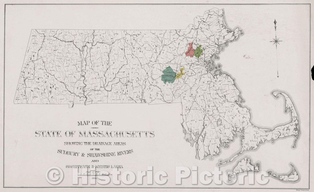
Historic Map : Map of the State of Massachusetts showing the drainage areas of the Sudbury and Shawshine Rivers and Cochituate and Mystic Lakes, 1886 , Vintage Wall Art

Map of the State of Massachusetts showing the drainage areas of the Sudbury and Shawshine Rivers and Cochituate and Mystic Lakes, 1886
From: $49.99

Historic Map : A New Map of Part of the United States of North America, containing those of New York, Vermont, New Hampshire, Massachusetts, Connecticut, Rhode Island, 1806 , Vintage Wall Art

A New Map of Part of the United States of North America, containing those of New York, Vermont, New Hampshire, Massachusetts, Connecticut, Rhode Island, 1806
From: $34.99

Historic Map : Map of the Railroads of the State of Massachusetts. 1912. Accompanying the report of the Railroad Commissioners. Corrected to Jan. 1, 1913., c. 1913 , Vintage Wall Art

Map of the Railroads of the State of Massachusetts. 1912. Accompanying the report of the Railroad Commissioners. Corrected to Jan. 1, 1913., c. 1913
From: $49.99

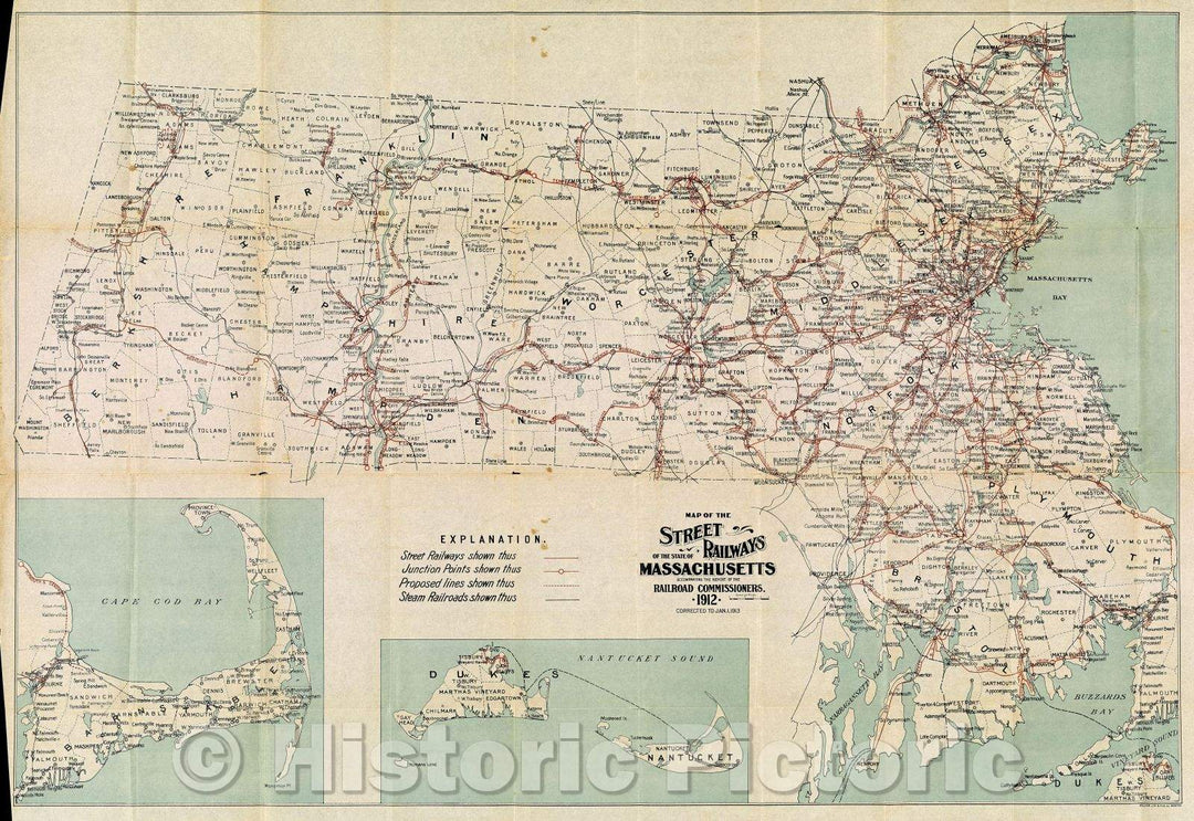
Historic Map : Map of the Street Railways of the State of Massachusetts. Accompanying the report of the Railroad Commissioners. 1912. Corrected to Jan. 1, 1913., 1913 , Vintage Wall Art

Map of the Street Railways of the State of Massachusetts. Accompanying the report of the Railroad Commissioners. 1912. Corrected to Jan. 1, 1913., 1913
From: $49.99

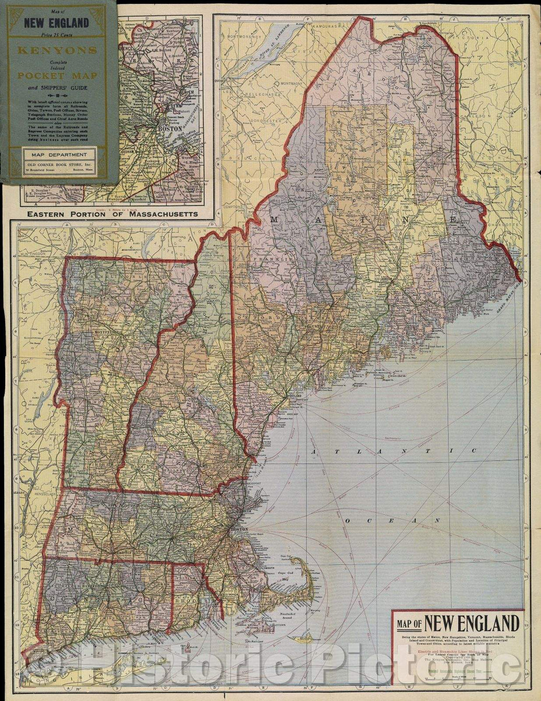
Historic Map : Map of New England Being the states of Maine, New Hampshire, Vermont, Massachusetts, Rhode Island and Connecticut with Population and Location, 1920 , Vintage Wall Art

Map of New England Being the states of Maine, New Hampshire, Vermont, Massachusetts, Rhode Island and Connecticut with Population and Location, 1920
From: $49.99

Historic Map : A New Map of Part of the United States of North America, Containing Those of New York, Vermont, New Hampshire, Massachusetts, Connecticut, Rhode Island, 1806 , Vintage Wall Art

A New Map of Part of the United States of North America, Containing Those of New York, Vermont, New Hampshire, Massachusetts, Connecticut, Rhode Island, 1806
From: $34.99

Historic Map : Map of the Northern, or, New England States of America, comprehending Vermont, New Hampshire, District of Main, Massachusetts, Rhode Island, 1795 , Vintage Wall Art

Map of the Northern, or, New England States of America, comprehending Vermont, New Hampshire, District of Main, Massachusetts, Rhode Island, 1795
From: $49.99

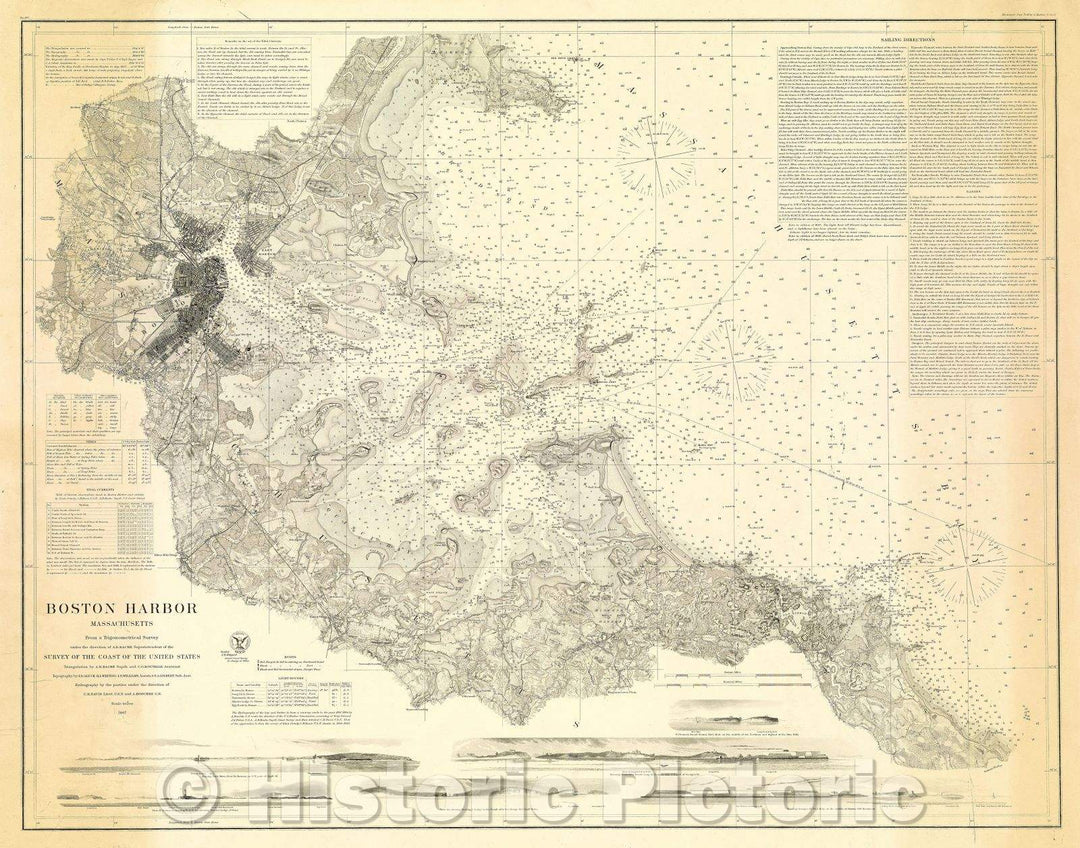
Historic Map : Boston Harbor, Massachusetts: Survey of the Coast of the United States, 1867 , Vintage Wall Art

Boston Harbor, Massachusetts: Survey of the Coast of the United States, 1867
From: $49.99

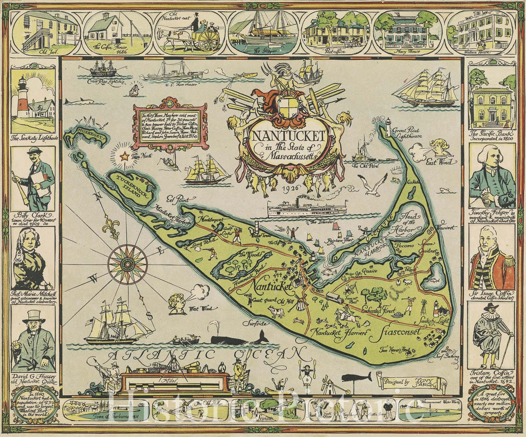
Historic Map : Nantucket in the State of Massachusetts, 1926 , Vintage Wall Art

Nantucket in the State of Massachusetts, 1926
From: $49.99

Historic Map : Boston Harbor Massachusetts Survey of the Coast of the United States, 1867 , Vintage Wall Art

Boston Harbor Massachusetts Survey of the Coast of the United States, 1867
From: $49.99

Historic Map : County and Township Map of the States of Massachusetts, Connecticut and Rhode Island, 1884 , Vintage Wall Art

County and Township Map of the States of Massachusetts, Connecticut and Rhode Island, 1884
From: $49.99

Historic Map : United States Maps, Massachusetts 1894 , Vintage Wall Art

United States Maps, Massachusetts 1894
From: $49.99

Historic Map : Railroad Maps of the United States, Western Massachusetts 1848 , Vintage Wall Art

Railroad Maps of the United States, Western Massachusetts 1848
From: $49.99

Historic Map : Official Topographical Atlas of Massachusetts, United States 1871 , Vintage Wall Art

Official Topographical Atlas of Massachusetts, United States 1871
From: $49.99

Historic Map : Massachusetts Railroad Commission Maps, Railroads of the State of Massachusetts 1895 , Vintage Wall Art

Massachusetts Railroad Commission Maps, Railroads of the State of Massachusetts 1895
From: $49.99

Historic Map : Massachusetts 1900 , Northeast U.S. State & City Maps , Vintage Wall Art

Northeast U.S. State & City Maps, Massachusetts 1900 circa
From: $49.99

Historic Map : County Atlas of Middlesex Massachusetts, United States 1875 , Vintage Wall Art

County Atlas of Middlesex Massachusetts, United States 1875
From: $49.99

Historic Map : The Connecticut Valley in Massachusetts 1910 , Northeast U.S. State & City Maps , Vintage Wall Art

Northeast U.S. State & City Maps, The Connecticut Valley in Massachusetts 1910 circa
From: $49.99

Historic Map : Railroad Maps of the United States, Connecticut & Massachusetts & Rhode Island 1848 , Vintage Wall Art

Railroad Maps of the United States, Connecticut & Massachusetts & Rhode Island 1848
From: $49.99

Map : Massachusetts 1930, Map of Massachusetts, the Old Bay State : a picture history map , Antique Vintage Reproduction

Map of Massachusetts, the Old Bay State : a picture history map / Elizabeth Shurtleff; approved by Tercentenary Conference of City and Town Committees, Inc.We print high quality reproductions of...
From: $49.99

Map : Massachusetts 1960, Historic Massachusetts, a travel map to help you feel at home in the Bay State , Antique Vintage Reproduction

Historic Massachusetts, a travel map to help you feel at home in the Bay State / designed and drawn by Ernest Dudley ChaseWe print high quality reproductions of historical maps,...
From: $49.99

Map : Massachusetts 1919, National Highways map of the State of Massachusetts : showing twelve hundred miles of national highways, Antique Vintage Reproduction

National Highways map of the State of Massachusetts : showing twelve hundred miles of national highways proposed by the National Highways Association / John C. Mulford, chief cartographer, G. Lombard,...
From: $49.99

Map : Georges Bank, Massachusetts, United States--east coast, Georges Bank, western part : special chart for fishing industry , Antique Vintage Reproduction

United States--east coast, Georges Bank, western part : special chart for fishing industry / published at Washington, D.C. July 1934 by the U.S. Coast and Geodetic Survey, R.S. Patton, DirectorWe...
From: $49.99

Map : Maps showing bottom sediments on the continental shelf of the northeastern United States - Cape Ann, Massachusetts to Casco Bay, Maine, 1975 Cartography Wall Art :

Maps showing bottom sediments on the continental shelf of the northeastern United States - Cape Ann, Massachusetts to Casco Bay, MaineWe print high quality reproductions of historical maps, photographs, prints,...
From: $49.99

Map : Bedrock geologic map of the State Line quadrangle, Columbia County, New York, and Berkshire County, Massachusetts, 1974 Cartography Wall Art :

Bedrock geologic map of the State Line quadrangle, Columbia County, New York, and Berkshire County, MassachusettsWe print high quality reproductions of historical maps, photographs, prints, etc. Because of their historical...
From: $49.99

Map : Bottom sediments on the continental shelf off the northeastern United States-Cape Cod to Cape Ann Massachusetts, 1973 Cartography Wall Art :

Bottom sediments on the continental shelf off the northeastern United States-Cape Cod to Cape Ann MassachusettsWe print high quality reproductions of historical maps, photographs, prints, etc. Because of their historical...
From: $49.99

Map : Preliminary materials map, Massachusetts portion of the State Line quadrangle, Massachusetts - New York, 1963 Cartography Wall Art :

Preliminary materials map, Massachusetts portion of the State Line quadrangle, Massachusetts - New YorkWe print high quality reproductions of historical maps, photographs, prints, etc. Because of their historical nature, some...
From: $34.99

Historic 1861 Map - Topographical map of The State of Massachusetts

Topographical map of the State of MassachusettsWe print high quality reproductions of historical maps, photographs, prints, etc. Because of their historical nature, some of these images may show signs of...
From: $49.99

Historic 1818 Map - Plan of Charlestown Peninsula in The State of Massachusetts

Plan of Charlestown peninsula in the state of MassachusettsWe print high quality reproductions of historical maps, photographs, prints, etc. Because of their historical nature, some of these images may show...
From: $49.99

Historic 1814 Map - Map of Boston in The State of Massachusetts : 1814

Map of Boston in the state of Massachusetts : 1814We print high quality reproductions of historical maps, photographs, prints, etc. Because of their historical nature, some of these images may...
From: $49.99

Historic 1899 Map - Map of The Electric Railways of The State of Massachusetts accompanying The Report of The Railroad commissioners, 1899.

Map of the electric railways of the state of Massachusetts accompanying the report of the railroad commissioners, 1899.We print high quality reproductions of historical maps, photographs, prints, etc. Because of...
From: $49.99

Historic 1858 Map - Map of Franklin County, Massachusetts : Based on The Trigonometrical Survey of The State : Details from Original surveys

Map of Franklin County, Massachusetts : based on the trigonometrical survey of the state : details from original surveysWe print high quality reproductions of historical maps, photographs, prints, etc. Because...
From: $49.99

Historic 1849 Map - A map of The New England States, Maine, New Hampshire, Vermont, Massachusetts, Rhode Island & Connecticut with The Adjacent Parts of New York & Lower Canada

A map of the New England states, Maine, New Hampshire, Vermont, Massachusetts, Rhode Island & Connecticut with the adjacent parts of New York & Lower Canada; compiled and published by...
From: $49.99

Historic 1971 Map - States of Massachusetts, Rhode Island, and Connecticut : Base map

States of Massachusetts, Rhode Island, and Connecticut : base mapWe print high quality reproductions of historical maps, photographs, prints, etc. Because of their historical nature, some of these images may...
From: $49.99

Historic 1846 Map - Sketch of The States of Massachusetts, Connecticut, and Rhode Island, and Parts of New Hampshire & New York exhibiting The Several Rail Road Routes Completed

Sketch of the states of Massachusetts, Connecticut, and Rhode Island, and parts of New Hampshire & New York exhibiting the several rail road routes completed, constructing, chartered & contemplated; published...
From: $34.99

Historic Map : 1860 County Map of the State of New York, New Hampshire, Vermont, Massachusetts, Rhode Island, and Connecticut : Vintage Wall Art

Vintage Map | 1860 County Map of the State of New York, New Hampshire, Vermont, Massachusetts, Rhode Island, and Connecticut | Williams, W.
From: $49.99

Historic Map : 1861 County Map of the States of New York, New Hampshire, Vermont, Massachusetts, Rhode Island and Connecticut : Vintage Wall Art

Vintage Map | 1861 County Map of the States of New York, New Hampshire, Vermont, Massachusetts, Rhode Island and Connecticut | Mitchell, S. Augustus, Jr.
From: $49.99

Historic Map : 1855 Map No.2, United States (Massachusetts, Connecticut and Rhode Island) : Vintage Wall Art

Vintage Map | 1855 Map No.2, United States (Massachusetts, Connecticut and Rhode Island) | Smith, Roswell C.
From: $49.99

1973 State Line, MA - Massachusetts - USGS Topographic Map

1973 State Line, MA - Massachusetts - USGS Topographic Map
From: $49.99

1944 State Line, MA - Massachusetts - USGS Topographic Map v2

1944 State Line, MA - Massachusetts - USGS Topographic Map v2
From: $229.99

1944 State Line, MA - Massachusetts - USGS Topographic Map

1944 State Line, MA - Massachusetts - USGS Topographic Map
From: $49.99

Historic Map - County Map of the States of New York, New Hampshire, Vermont, Massachusetts, Rhode Id. And Connecticutt, 1865, Samuel Augustus Mitchell Jr. v2

County Map of the States of New York, New Hampshire, Vermont, Massachusetts, Rhode Id. And Connecticutt, 1865, Samuel Augustus Mitchell Jr.
From: $49.99

Historic Map - The State of Massachusetts, 1814, Mathew Carey - Vintage Wall Art

The State of Massachusetts, 1814, Mathew Carey
From: $49.99

Historic Map - County Map of the States of New York, New Hampshire, Vermont, Massachusetts, Rhode Id. And Connecticutt, 1865, Samuel Augustus Mitchell Jr. v1

County Map of the States of New York, New Hampshire, Vermont, Massachusetts, Rhode Id. And Connecticutt, 1865, Samuel Augustus Mitchell Jr.
From: $49.99

Historic Map - The State of Massachusetts, 1814, Mathew Carey - Vintage Wall Art

The State of Massachusetts, 1814, Mathew Carey
From: $49.99

Historic Map - Map of Massachusetts The Old Bay State, 1930, Elizabeth Shurtleff - Vintage Wall Art

Map of Massachusetts The Old Bay State, 1930, Elizabeth ShurtleffWe print high quality reproductions of historical maps, photographs, prints, etc. Because of their historical nature, some of these images may...
From: $49.99

Historic Map - Map of the Northern New England States of America, with Vermont, New Hampshire, Maine, Massachusetts, Rhode-Island, and Conneticutt, 1794 - Vintage Wall Art

Map of the Northern New England States of America, with Vermont, New Hampshire, Maine, Massachusetts, Rhode-Island, and Conneticutt, 1794We print high quality reproductions of historical maps, photographs, prints, etc. Because...
From: $49.99

Historic Map - United States of North America -Maine, N Hampshire, Vermont, N York, Massachusetts, Rhode Id, Connecticut, 1855 - Vintage Wall Art

United States of North America --Maine, N Hampshire, Vermont, N York, Massachusetts, Rhode Id, Connecticut, 1855We print high quality reproductions of historical maps, photographs, prints, etc. Because of their historical...
From: $49.99

Historic Map - Muskeget Channel Massachusetts, 1859, United States Coast Survey - Vintage Wall Art

Muskeget Channel Massachusetts , 1859, United States Coast SurveyWe print high quality reproductions of historical maps, photographs, prints, etc. Because of their historical nature, some of these images may show...
From: $49.99

Historic Map : Map of the Railroads of the State of Massachusetts, 1874, Rand, Avery & Co., Vintage Wall Art

Map of the Railroads of the State of Massachusetts, 1874, Rand, Avery & Co.
From: $49.99

Historic Map : The State of Massachusetts from the best Authorities. 1799, 1799, John Payne, Vintage Wall Art

The State of Massachusetts from the best Authorities. 1799, 1799, John Payne
From: $49.99

Historic Map - The States of Massachusetts Connecticut And Rhode Island From the best Authorities, 1834, Andrus - Vintage Wall Art

The States of Massachusetts Connecticut And Rhode Island From the best Authorities , 1834, AndrusWe print high quality reproductions of historical maps, photographs, prints, etc. Because of their historical nature,...
From: $49.99

Historic Map : County and township map of the states of Massachusetts, Connecticut and Rhode Island, 1874, Vintage Wall Art

County and township map of the states of Massachusetts, Connecticut and Rhode Island, 1874
From: $49.99

Historic Map : Nantucket in The State of Massachusetts, 1926 Pictorial Map - Vintage Wall Art

Nantucket in The State of Massachusetts, 1926 Pictorial Map
From: $49.99

Historic Map : 1957 Historic Massachusetts : a travel map to help you feel at home in the Bay State - Vintage Wall Art

1957 Historic Massachusetts : a travel map to help you feel at home in the Bay State
From: $49.99

Historic Map : 1865 County map of the State of New York, New Hampshire, Vermont. Massachusetts, Rhode Id. Connecticut - Vintage Wall Art

1865 County map of the State of New York, New Hampshire, Vermont. Massachusetts, Rhode Id. Connecticut
From: $49.99

Historic Map : 1825 Map Of The States Of Maine, New Hampshire, Vermont, Massachusetts, Connecticut & Rhode Island. - Vintage Wall Art

1825 Map Of The States Of Maine, New Hampshire, Vermont, Massachusetts, Connecticut & Rhode Island.
From: $49.99

Historic Map : Massachusetts, Atlantic Seaboard (United States) 1667 Pas caerte van Nieu Nederlandt en de Engelsche Virginies. , Vintage Wall Art

Massachusetts, Atlantic Seaboard (United States) 1667 Pas caerte van Nieu Nederlandt en de Engelsche Virginies. , Vintage Wall Art
From: $49.99

Historic Map : National Atlas - 1874 County and Township Map of the States of Massachusetts, Connecticut, and Rhode Island. - Vintage Wall Art

National Atlas - 1874 County and Township Map of the States of Massachusetts, Connecticut, and Rhode Island.
From: $49.99

Historic Map : National Atlas - 1795 State of Massachusetts. - Vintage Wall Art

National Atlas - 1795 State of Massachusetts.
From: $49.99

Historic Map : 1814 The State of Massachusetts : Vintage Wall Art

Vintage Map | 1814 The State of Massachusetts | Carey, Mathew
From: $49.99

Historic Map : 1857 States Of Maine, New Hampshire, Vermont, Massachusetts, Rhode Island, Connecticut, New York, Pennsylvania, And New Jersey. - Vintage Wall Art

1857 States Of Maine, New Hampshire, Vermont, Massachusetts, Rhode Island, Connecticut, New York, Pennsylvania, And New Jersey.
From: $49.99

Historic Map : 1833 States of Maine, New Hampshire, Vermont, Massachusetts, Connecticut, Rhode Island. - Vintage Wall Art

1833 States of Maine, New Hampshire, Vermont, Massachusetts, Connecticut, Rhode Island.
From: $49.99

Historic Map : Map of The State of Massachusetts, 1861 - Vintage Wall Art

Topographical Map Of The State Of Massachusetts Based On The Trigonometrical Survey By Simeon Borden, The details from Actual Surveys under the direction of H.F. Walling. Published by H. &...
From: $49.99

Historic Map : Pocket Map, The States of Massachusetts, Connecticut And Rhode Island 1832 - Vintage Wall Art

The States Of Massachusetts, Connecticut And Rhode Island From the best Authorities. Published by Andrus & Judd Hartford, Conn. 1832. Copy Right secured according to Act of Congress. | The...
From: $49.99

Historic Map - Map of the States of Maine, New Hampshire, Vermont, Massachusetts, Connecticut and Rhode Island, 1841, Henry Schenk Tanner - Vintage Wall Art

Map of the States of Maine, New Hampshire, Vermont, Massachusetts, Connecticut and Rhode Island, 1841, Henry Schenk TannerWe print high quality reproductions of historical maps, photographs, prints, etc. Because of...
From: $49.99

Historic Map - County Map of the States of New York, New Hampshire, Vermont, Massachusetts, Rhode Id. And Connecticutt, 1865, Samuel Augustus Mitchell Jr. v3

County Map of the States of New York, New Hampshire, Vermont, Massachusetts, Rhode Id. And Connecticutt, 1865, Samuel Augustus Mitchell Jr.
From: $49.99

Historic Map : Map of Massachusetts, The Old Bay State, 1930 - Vintage Wall Art

Map of Massachusetts, The Old Bay State. A Picture History Map | Map of Massachusetts, The Old Bay State. | Approved by the Tercentenary Conference of City and Town Committees....
From: $49.99

Historic Map : Historic Massachusetts : a travel map to help you feel at home in the Bay State, 1957 v2

Historic Massachusetts : a travel map to help you feel at home in the Bay State. Massachusetts. Department of Commerce, 334 Boylston St. Boston, 16 Mass. Designed and drawn by...
From: $49.99

Historic Map : Pocket Map, The State of Massachusetts 1827 - Vintage Wall Art

The State of Massachusetts. | The State of Massachusetts. | Reissue of M. Carey 1818 edition General Atlas. Map is folded into red stamped card covers 13x7 with "Massachusets" misspelled...
From: $49.99

Historic Map : Historic Massachusetts : a travel map to help you feel at home in the Bay State, 1957 v1

Historic Massachusetts : a travel map to help you feel at home in the Bay State. Massachusetts. Department of Commerce, 334 Boylston St. Boston, 16 Mass. Designed and drawn by...
From: $49.99

Historical Map, 1800 The State of Massachusetts : compiled from The Best Authorities, Vintage Wall Art

The state of Massachusetts : compiled from the best authorities
From: $49.99

Historical Map, 1850-1869 Plan of The Estate of Stephen R. and Charles F. Benton, Richmond Township, Berkshire Co, State of Massachusetts, Vintage Wall Art

Manuscript map of a farm off of present day Swamp Road, near the intersection with Gordon's Way, in Richmond Township, Mass. Shows structures, gardens, pastures, woods etc. Includes a birds-eye...
From: $49.99

Historical Map, 1799 The State of Massachusetts from The Best Information, Vintage Wall Art

The state of Massachusetts from the best information
From: $119.99

Historical Map, 1795 The state of Massachusetts, Vintage Wall Art

This is the first state map of Massachusetts to be published in the young republic. The Massachusetts state government, realizing that efficient communications, not just postal routes and roads, but...
From: $49.99
Showing products 1 - 80 of 128

Free Shipping

We offer Free Standard Shipping for all orders within the United States. If you want your stuff there faster, see Expedited and Overnight shipping cost at checkout.

Our Guarantee

If you are not completely satisfied, just send the product back to us and we'll replace it with another one of your choice OR refund your purchase price 100%. Our address is on the contact us page.

100% Satisfaction

We painstakingly labor over the preparation and printing of each individual product we sell. We stand behind the materials and workmanship, and want nothing more than for you to be 100% happy with your order.

Just added to your wishlist:
My Wishlist
Just added to your cart:
My Cart