-
-


-
Wall Color
in
Uncheck to hide the white line Check to show the white line -
-
.


Frame
Room
Gallery
Historic Map : Colton Map of Utah and New Mexico (First Edition, First State) , 1855, Vintage Wall Art
Historic Map : Colton Map of Utah and New Mexico (First Edition, First State) , 1855, Vintage Wall Art
Note: Sold out or unavailable
Couldn't load pickup availability
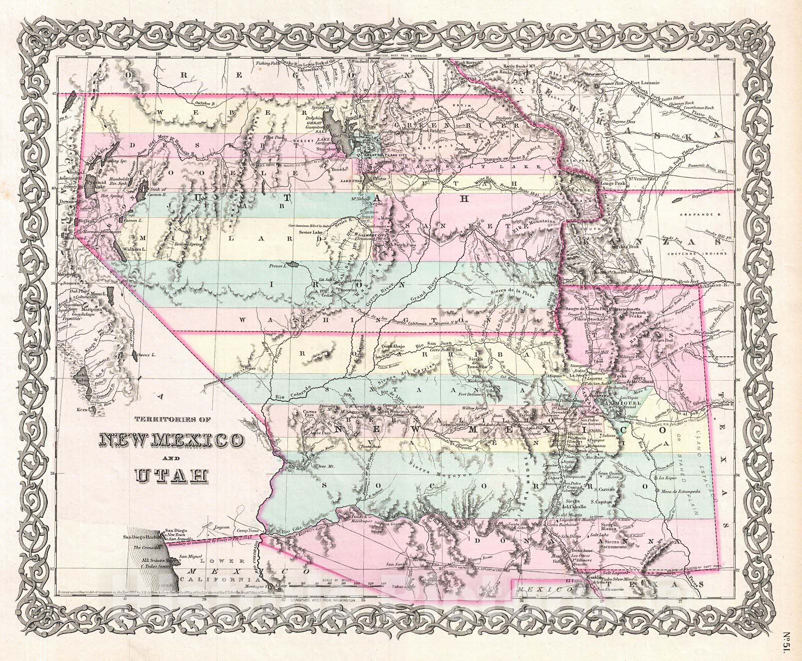
An iconic map of the American west and one of the rarest and most desirable of all Colton atlas maps. This is an extraordinary example of the first edition first state of Colton's 1855 map of the territories of New Mexico and Utah. This is one of the rarest and most desirable of all Colton atlas maps. Based on earlier wall map produced by Colton and D. Griffing Johnson, this map details the regions between the California and Texas and between Oregon and Mexico. Covers territorial New Mexico and Utah including the modern day states of Nevada, Colorado, and Arizona. Colton identifies a number of important emigrant and exploratory routes including Fremont's, Kearney's and the Spanish Trail from New Mexico to Los Angeles. Also shows three of the routes proposed for the Pacific Railroad. The Beswith route runs across the north of the map passing just south of Great Salt Lake. In the middle of the map the Gunnison Route is shown, as well as the site, near Lake Sevier, where Captain Gunnison was killed by the Ute Indians. Across the bottom of the map, the Parke route, which precipitated the Gadsden Purchase, is also noted. Colton identifies Fillmore City as the capital of the Utah Territory and Santa Fe as the capital of New Mexico. This map further identifies various forts, rivers, mountain passes, fords, and an assortment of additional topographical detail. Map is hand colored in pink, green, yellow and blue pastels to define territory and state boundaries. Surrounded by Colton's typical spiral motif border. Dated and copyrighted to J. H. Colton, 1855. Published from Colton's 172 William Street Office in New York City. Issued as page no. 51 in volume 1 of the first edition of George Washington Colton's 1855 Atlas of the World .
- MUSEUM QUALITY INKS AND PAPER: Printed on thick 192gsm heavyweight matte paper with archival giclee inks, this historic fine art will decorate your wall for years to come.
- VINTAGE MAP REPRODUCTION: Add style to any room's decor with this beautiful print. Whether your interior design is modern or classic, a map is never out of fashion.
- ATTENTION TO DETAIL: We edit every antique map for image quality, color and vibrance, so it can look its best while retaining historical character. Makes a great gift!
- FRAME READY: Your unframed poster will arrive crease-free, rolled in a sturdy mailing tube. Many maps fit easy-to-find standard size frames 16x20, 16x24, 18x24, 24x30, 24x36, saving on custom framing.
- Watermarks will not appear in the printed picture. Some blemishes, tears, or stamps may be removed from the final print.
What our customers are saying
★★★★★I purchased an historic map, 16x24 inch. It is beautifully printed on heavy stock. The lettering, colors, and details of the map are crisp and easy to read. I am highly satisfied and would certainly purchase from Historic Pictoric again!
Kent A.
★★★★★Ordered the Pan American Midway print to fit a lovely thrift-store gilded frame. I love showing off Buffalo's rich history and this is a pretty entertaining photo from 1901. Prompt shipping. Sturdy packaging.
Cindy O.
★★★★★I received my print within days of ordering, and it arrived well packed in a mailing tube. The print is high quality and exactly as advertised. I will use Historic Pictoric again in the future!
Cheryl H.
★★★★★Excellent product. Great fidelity in reproduction of the original. Fine/minute details were sharp, colors were vibrant, and thickness, texture and overall feel and quality of the paper were excellent. Very satisfied with my purchase.
Konrad B.
★★★★★I have purchased six maps from Historic Pictoric. I find the quality to be excellent. Their customers service is also excellent. Outstanding! I called to exchange a few for different sizes and I could not have asked for a better experience.
Aaron C.
★★★★★The original map I ordered lacked some of the detail that I had hoped for, but they responded with several more map possibilities to choose from. Excellent service- a far step beyond what anyone expects from online purchases.
Dan M.
★★★★★I am a owner of 5 maps from Historic Pictoric. From Okinawa, 1945, Europe 1940-1945 battle maps. Now they’re helping me with the battle of Gettysburg. These maps are so much superior to the map on a page in a book. I have framed two of them.
Steven Ko
★★★★★Great heavy paper quality and clarity of my nautical map. Will be a great addition to our home close to the beach!
Jennifer A
