Skip to content
icon-X
Close menu
Maps
World Maps
World War 2 Maps
Pictorial Maps
USGS TopoGraphic Maps
Art Prints
Blueprints
Fine Art Museum Collections
Claude Monet
Photographs
Modern Photos
Posters
Collections
Kid's Room
Autos, Trains & Rails
Monet and Manet
Brewery, Beer, Liquor & more
Holiday Ready to Gift Products
Log in
Follow Us
instagram
Instagram
Facebook
twitter
Twitter
Maps
World Maps
World War 2 Maps
Pictorial Maps
USGS TopoGraphic Maps
Art Prints
Blueprints
Fine Art Museum Collections
Claude Monet
Photographs
Modern Photos
Posters
Collections
Kid's Room
Autos, Trains & Rails
Monet and Manet
Brewery, Beer, Liquor & more
Holiday Ready to Gift Products
account
Log in
icon-search
Search
icon-hamburger
Site navigation
icon-bag-minimal
Cart
Search
Search
Free economy shipping for unframed orders of $75 or more!
Filter
icon-X
Close menu
State Maps
icon-filter
Filter
Historic 1924 Map - Aeronautical Strip maps of The United States. - No. 43 Recto, 1929 - rev. 1932 - Air Corps map
From:
$29.99
Historic 1882 Map - Historical Hand-Atlas, Illustrated - Map of The United States - Historical Hand Atlas, Illustrated, General & Local
From:
$49.99
Historic 1924 Map - Aeronautical Strip maps of The United States. - No. 45, 1928 - Air Corps map
From:
$34.99
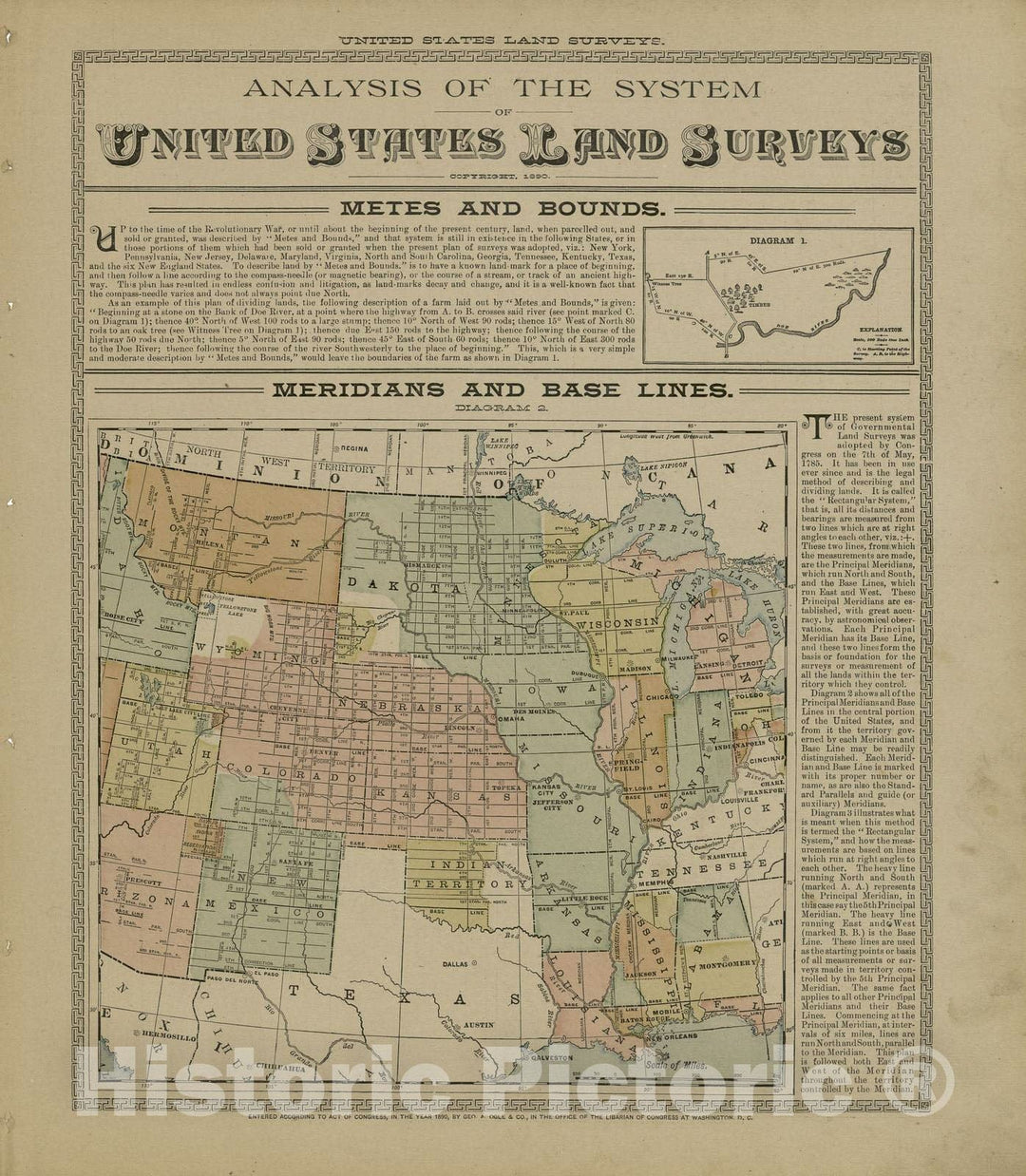
Historic 1893 Map - Plat Book of Douglas Co, Illinois - Analysis of The System, United States Land Surveys - Plat Book of Douglas County, Illinois
From:
$49.99
Historic 1924 Map - Aeronautical Strip maps of The United States. - No. 38, 1926 - rev. 1927 - Air Corps map
From:
$49.99
Historic 1891 Map - Atlas of Bucks Co, Penna. - Gray's New Map of The United States - Atlas of Bucks County, Pennsylvania
From:
$49.99
Historic 1887 Map - Colby's Atlas of The State of Maine - Map of Aroostook County Maine
From:
$49.99
Historic 1924 Map - Aeronautical Strip maps of The United States. - No. 121, 1930 - Air Corps map
From:
$29.99
Historic 1924 Map - Aeronautical Strip maps of The United States. - No. 32, 1924 - Air Corps map
From:
$34.99
Historic 1970 Map - The National Atlas of The United States of America. - Power and Production Consumption
From:
$49.99
Historic 1924 Map - Aeronautical Strip maps of The United States. - No. 26, 1923 - rev. 1928 - Air Corps map
From:
$34.99
Historic 1901 Map - Standard Atlas of Monroe County, Illinois : Including a plat Book of The Villages, Cities and townships of The County, map of The State - United States
From:
$49.99
Historic 1898 Map - Statistical Atlas of The United States, Percentage of The Native White Population of Native Parentage in Each Age Group, by Sex: 1890
From:
$49.99
Historic 1970 Map - The National Atlas of The United States of America. - Family Income
From:
$49.99
Historic 1924 Map - Aeronautical Strip maps of The United States. - No. 4, 1929 - Air Corps map
From:
$29.99
Historic 1902 Map - Standard Atlas of Worth County, Missouri : Including a plat Book of The Villages, Cities and townships of The County, map of The State - Grant City
From:
$49.99
Historic 1970 Map - The National Atlas of The United States of America. - Sea Tempuratures and Salinity
From:
$49.99
Historic 1898 Map - Robertson's Geographic History of America and The United States - Spanish in America at Close of The Sixteenth Century
From:
$49.99
Historic 1887 Map - Colby's Atlas of The State of Maine - City of Ellsworth
From:
$49.99
icon-chevron-left
Previous
1
…
246
247
248
249
250
…
509
icon-chevron
Next
icon-X
"Close (esc)"
icon-chevron-left
icon-X
icon-chevron
icon-X
State Wall Maps, Posters & Prints