-
-


-
Wall Color
in
Uncheck to hide the white line Check to show the white line -
-
.


Frame
Room
Gallery
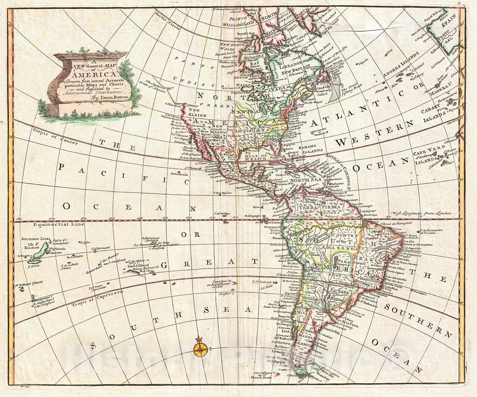
Historic Map : Bowen Map of North America and South America (Western Hemisphere) , 1747, Vintage Wall Art
Historic Map : Bowen Map of North America and South America (Western Hemisphere) , 1747, Vintage Wall Art
Note: Sold out or unavailable
Couldn't load pickup availability
A stunning 1747 decorative map of the Western Hemisphere by E. Bowen. Covers North and South America as well as much of the Pacific and the Atlantic as far as Spain and the Canary Islands. Details America during the Colonial Period. In North America, England controls the colonies along the eastern coast of the continent and surrounding the Hudson Bay. France occupies Louisiana, parts of Canada, and the Great Lakes region. Spain controls the western part of the continent as well as Florida, Mexico, most of the West Indies and, with the exception of Portuguese Brazil, all of South America. Most of western North America is unexplored though Bowen does name several known points along the coast, including the Bay of the Conception and Cape Mendocino. He also notes Drakes Port where Francis Drake laid claim to New Albion for England in 1579. Though the true location of Drakes Port is the object of considerable debate, most associate it with Pelican Bay on the border of California and Oregon. The Pelican was Francis Drake's ship and the bay is named after it to this day. Further north the coastline becomes speculative, though the Supposed Straits of Annian are noted. The Straits of Anian are said to be the entrance to a Northwest Passage discovered in the 16th century by the apocryphal navigator Admiral de Fonte. Inland, near the northern tip of Baja, Bowen draws Great Teguayo, one of the Kingdoms of Gold presumed to be found in the unexplored American west. Understandably misinterpreting the flood plain as a gigantic inland sea, they named it after the local inhabitants, the Xaraies. The South Pacific portions of this map contain numerous islands, some of which are real, but most of which are difficult to associate with any actual islands. The Solomon Islands are drawn wildly out of proportion to their actual size leading to speculation that they may have been confused with nearby New Britain.
- MUSEUM QUALITY INKS AND PAPER: Printed on thick 192gsm heavyweight matte paper with archival giclee inks, this historic fine art will decorate your wall for years to come.
- VINTAGE MAP REPRODUCTION: Add style to any room's decor with this beautiful print. Whether your interior design is modern or classic, a map is never out of fashion.
- ATTENTION TO DETAIL: We edit every antique map for image quality, color and vibrance, so it can look its best while retaining historical character. Makes a great gift!
- FRAME READY: Your unframed poster will arrive crease-free, rolled in a sturdy mailing tube. Many maps fit easy-to-find standard size frames 16x20, 16x24, 18x24, 24x30, 24x36, saving on custom framing.
- Watermarks will not appear in the printed picture. Some blemishes, tears, or stamps may be removed from the final print.
What our customers are saying
★★★★★I purchased an historic map, 16x24 inch. It is beautifully printed on heavy stock. The lettering, colors, and details of the map are crisp and easy to read. I am highly satisfied and would certainly purchase from Historic Pictoric again!
Kent A.
★★★★★Ordered the Pan American Midway print to fit a lovely thrift-store gilded frame. I love showing off Buffalo's rich history and this is a pretty entertaining photo from 1901. Prompt shipping. Sturdy packaging.
Cindy O.
★★★★★I received my print within days of ordering, and it arrived well packed in a mailing tube. The print is high quality and exactly as advertised. I will use Historic Pictoric again in the future!
Cheryl H.
★★★★★Excellent product. Great fidelity in reproduction of the original. Fine/minute details were sharp, colors were vibrant, and thickness, texture and overall feel and quality of the paper were excellent. Very satisfied with my purchase.
Konrad B.
★★★★★I have purchased six maps from Historic Pictoric. I find the quality to be excellent. Their customers service is also excellent. Outstanding! I called to exchange a few for different sizes and I could not have asked for a better experience.
Aaron C.
★★★★★The original map I ordered lacked some of the detail that I had hoped for, but they responded with several more map possibilities to choose from. Excellent service- a far step beyond what anyone expects from online purchases.
Dan M.
★★★★★I am a owner of 5 maps from Historic Pictoric. From Okinawa, 1945, Europe 1940-1945 battle maps. Now they’re helping me with the battle of Gettysburg. These maps are so much superior to the map on a page in a book. I have framed two of them.
Steven Ko
★★★★★Great heavy paper quality and clarity of my nautical map. Will be a great addition to our home close to the beach!
Jennifer A