-
-


-
Wall Color
in
Uncheck to hide the white line Check to show the white line -
-
.


Frame
Room
Gallery
Historic Map : Buache de Neuville Physical Map of France, 1770, Vintage Wall Art
Historic Map : Buache de Neuville Physical Map of France, 1770, Vintage Wall Art
Note: Sold out or unavailable
Couldn't load pickup availability
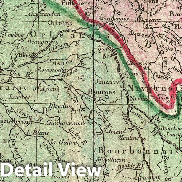
A scarce 1770 physical map of France by Philippe Buache. The map covers all of France highlighting the various river basins, including Rhine, Rhone, Meuse, Seine, Loire, Garonne, and its coastal basins. Various rivers, mountain ranges, gulfs, lakes, plateaus and other important natural and topographic features are identified, with relief shown by hachures. Several important towns and cities are also noted. The map also includes important notes and information in the lower left and upper right quadrants.
Historically, France at this time was under the reign of Louis in xVI, the last Ancien Regime French King before the French Revolution. Louis in xVI was probably not the worse king France ever had, but he was definitely in the wrong place at the wrong time. In the years just prior to the 1889 French Revolution, France had entered a period of sustained economic decline. French involvement in the American Revolutionary War and the Seven Years War strained the national treasury and put increased pressure on the peasantry. This was compounded by several years of poor harvest brought on by erratic weather patterns associated with el Nino and the 1783 eruptions of the Icelandic Laki and Grimsvotn volcanoes. The Royal court at Versailles, isolated and seemingly indifferent to the hardships of the lower classes, proved an easy target. Events came to a head on July 14th, 1789, when angry insurgents stormed the Bastille prison, giving birth to the bloody French Revolution and effectively ending the French monarchy. This map was issued as part of Philippe Buache and Guillaume Delisle's Cartes et Tables de la Geographie Physique ou Naturelle.
- MUSEUM QUALITY INKS AND PAPER: Printed on thick 192gsm heavyweight matte paper with archival giclee inks, this historic fine art will decorate your wall for years to come.
- VINTAGE MAP REPRODUCTION: Add style to any room's decor with this beautiful print. Whether your interior design is modern or classic, a map is never out of fashion.
- ATTENTION TO DETAIL: We edit every antique map for image quality, color and vibrance, so it can look its best while retaining historical character. Makes a great gift!
- FRAME READY: Your unframed poster will arrive crease-free, rolled in a sturdy mailing tube. Many maps fit easy-to-find standard size frames 16x20, 16x24, 18x24, 24x30, 24x36, saving on custom framing.
- Watermarks will not appear in the printed picture. Some blemishes, tears, or stamps may be removed from the final print.
Why choose Historic Pictoric
Every artwork we offer is carefully edited by our small but dedicated team of image professionals, ensuring each detail is perfect. We print every order to demand right here in the USA, treating every piece with the same care and attention we would give our own work. From editing to printing to packaging, we take pride in delivering artwork that meets our high standards—and we love knowing it’s heading to a home where it will be appreciated.