-
-


-
Wall Color
in
Uncheck to hide the white line Check to show the white line -
-
.


Frame
Room
Gallery
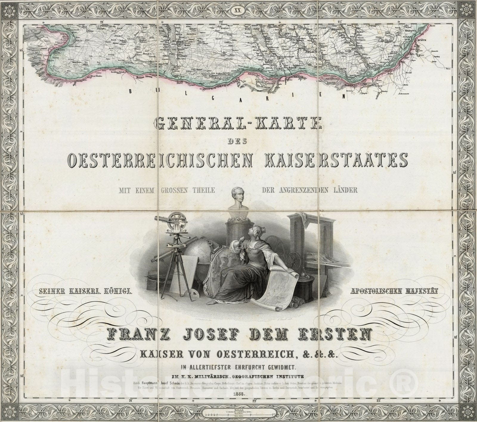
Historic Map : Bulgaria, Central Europe Case Map, Sheet XX: Karte Des Oesterreichischen Kaiserstaates. 1856 , Vintage Wall Art
Historic Map : Bulgaria, Central Europe Case Map, Sheet XX: Karte Des Oesterreichischen Kaiserstaates. 1856 , Vintage Wall Art
Note: Sold out or unavailable
Couldn't load pickup availability
(Sheet XX) General - Karte Des Oesterreichischen Kaiserstaates. Mit Einem Grossen Theile Der Angrenzenden Lander. Seiner Kaiserl. Konigl. Apostolischen Majestat Franz Josef Dem Ersten Kaiser Von Oesterreich, &. &. &. In Allertiefster Ehrfurcht Gewidmet. Im K.K. Militarisch-Geografischen Institute durch Hauptmann Josef Scheda des k.k. Ingenieur-Geografen-Corps. Abtheilungs-Chef im obigen Institute. Ritter mehrerer hohen Orden, Besitzer der grossen goldenen Medaille fur Kunst und Wissenschaft von Oesterreich, Preussen, Hannover und Sachsen, Mitglied des geografischen Vereins zu Berlin und Darmstadt, berbeitet und herausgegeben. (title sheet illustration) T. Haselwander fec. F. Bruckl sculp. | By Joseph Scheda, Engineer of the Geographic Corps, Militarisch Geografischen Institute, Austria. Comprised of 20 sheets, each dissected into 6 sections. Incredible detail throughout the map. A triumph of Austrian/German engraving. The 20 sheets cover most of middle and southern Europe. With an index map titled "Ubersicht zur Zusammenstellung der Blaetter fur die General Karte des oesterreichischen Kaiserstaates." Scheda did a 25 sheet map of Europe. Scheda lived from 1815-1888 (Phillips) and did a Hand Atlas in 1879 with A. Steinhauser (Phillips 6201) which we gather was largely a Physical Atlas. Outline color. Map sheets fold each with a paste down label on the end sheet showing its corresponding portion of the map and roman numeral as shown in the index map. The sheets are then folded into a maroon cloth covered folding board and outer quarter leather maroon cloth slip case 26x21 with "General-Karte Der Oesterreichischen Monarchie von J. Scheda" and a decorative design with an illustration of a globe stamped in gilt on the spine.
We print high quality reproductions of historical maps, photographs and prints. Some of these images may show signs of wear and tear - we believe that in many cases this contributes to the aesthetics of the item.
- MUSEUM QUALITY INKS AND PAPER: Printed on thick 192gsm heavyweight matte paper with archival giclee inks, this historic fine art will decorate your wall for years to come.
- VINTAGE MAP REPRODUCTION: Add style to any room's decor with this beautiful print. Whether your interior design is modern or classic, a map is never out of fashion.
- ATTENTION TO DETAIL: We edit every antique map for image quality, color and vibrance, so it can look its best while retaining historical character. Makes a great gift!
- FRAME READY: Your unframed poster will arrive crease-free, rolled in a sturdy mailing tube. Many maps fit easy-to-find standard size frames 16x20, 16x24, 18x24, 24x30, 24x36, saving on custom framing.
- Watermarks will not appear in the printed picture. Some blemishes, tears, or stamps may be removed from the final print.
What our customers are saying
★★★★★I purchased an historic map, 16x24 inch. It is beautifully printed on heavy stock. The lettering, colors, and details of the map are crisp and easy to read. I am highly satisfied and would certainly purchase from Historic Pictoric again!
Kent A.
★★★★★Ordered the Pan American Midway print to fit a lovely thrift-store gilded frame. I love showing off Buffalo's rich history and this is a pretty entertaining photo from 1901. Prompt shipping. Sturdy packaging.
Cindy O.
★★★★★I received my print within days of ordering, and it arrived well packed in a mailing tube. The print is high quality and exactly as advertised. I will use Historic Pictoric again in the future!
Cheryl H.
★★★★★Excellent product. Great fidelity in reproduction of the original. Fine/minute details were sharp, colors were vibrant, and thickness, texture and overall feel and quality of the paper were excellent. Very satisfied with my purchase.
Konrad B.
★★★★★I have purchased six maps from Historic Pictoric. I find the quality to be excellent. Their customers service is also excellent. Outstanding! I called to exchange a few for different sizes and I could not have asked for a better experience.
Aaron C.
★★★★★The original map I ordered lacked some of the detail that I had hoped for, but they responded with several more map possibilities to choose from. Excellent service- a far step beyond what anyone expects from online purchases.
Dan M.
★★★★★I am a owner of 5 maps from Historic Pictoric. From Okinawa, 1945, Europe 1940-1945 battle maps. Now they’re helping me with the battle of Gettysburg. These maps are so much superior to the map on a page in a book. I have framed two of them.
Steven Ko
★★★★★Great heavy paper quality and clarity of my nautical map. Will be a great addition to our home close to the beach!
Jennifer A