-
-


-
Wall Color
in
Uncheck to hide the white line Check to show the white line -
-
.


Frame
Room
Gallery
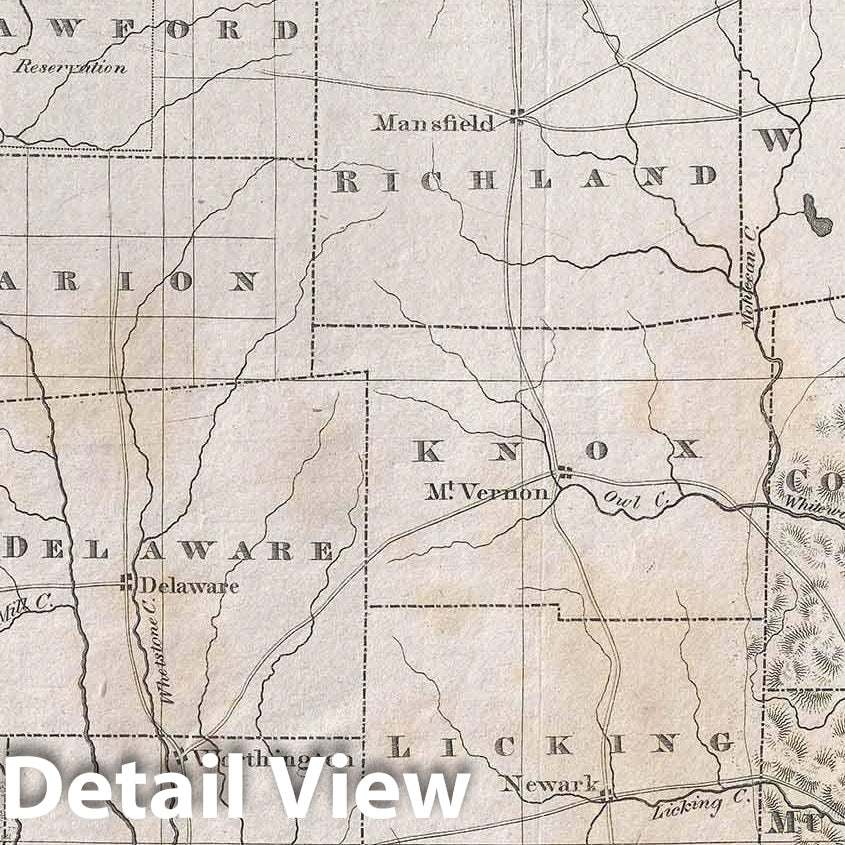
Historic Map : Caleb Atwater Antique Map of Ohio, 1820, Vintage Wall Art
Historic Map : Caleb Atwater Antique Map of Ohio, 1820, Vintage Wall Art
Note: Sold out or unavailable
Couldn't load pickup availability
One of the earliest obtainable specific large format maps of Ohio from the early part of the 19th century. This 1820 map of Ohio was engraved by Abner Reed and published by Caleb Atwater in his Description of the Antiquities discovered in the State of Ohio (Archaeologica Americana, Vol 1, 1820). The map covers all of modern day Ohio from Lake Erie to the Ohio River and from Indiana to Pennsylvania. It offers exceptionally fine detail along the southern tier and in the southeastern quadrant where topography is finely rendered using hachures. Fully 70 counties are identified, as are most major roadways, rives, and important settlements. The Black Swamp in northwestern part of the state, the 'Limestone Region' in the southwest, and the 'Unbroken Sandstone Region' in southeastern Ohio are all identified.
In the upper left quadrant there is a disputed boundary with Michigan associated with the bloodless Toledo War of 1835 and 1836. Both states laid claim to a sliver of land known as the Toledo Strip, valuable for its access to the a the valuable Toledo Port on Lake Erie. Both states raised militias and threatened military action from across the Maumee River, but nothing more severe than taunting ensued. Michigan acquiesced to Ohio's border demands in order to be admitted to the Union in 1837, gaining in consolation the mineral-rich Upper Peninsula.
This map consolidates the work of two influential Ohio mapmakers, John Kilbourne of Columbus, who authored the Ohio Gazetteer), and Alexander Bourne. The intention of the map, to illustrate Atwater's work on the American Indians of Ohio, manifests in the form of increased colonial encroachment into Indian lands, identified as 'Reserves' throughout the map.
All in all, a scarce and important map of Ohio. Engraved by East Windsor Connecticut in July of 1820 by Abner Reed.
- MUSEUM QUALITY INKS AND PAPER: Printed on thick 192gsm heavyweight matte paper with archival giclee inks, this historic fine art will decorate your wall for years to come.
- VINTAGE MAP REPRODUCTION: Add style to any room's decor with this beautiful print. Whether your interior design is modern or classic, a map is never out of fashion.
- ATTENTION TO DETAIL: We edit every antique map for image quality, color and vibrance, so it can look its best while retaining historical character. Makes a great gift!
- FRAME READY: Your unframed poster will arrive crease-free, rolled in a sturdy mailing tube. Many maps fit easy-to-find standard size frames 16x20, 16x24, 18x24, 24x30, 24x36, saving on custom framing.
- Watermarks will not appear in the printed picture. Some blemishes, tears, or stamps may be removed from the final print.
Why choose Historic Pictoric
Every artwork we offer is carefully edited by our small but dedicated team of image professionals, ensuring each detail is perfect. We print every order to demand right here in the USA, treating every piece with the same care and attention we would give our own work. From editing to printing to packaging, we take pride in delivering artwork that meets our high standards—and we love knowing it’s heading to a home where it will be appreciated.
- Choosing a selection results in a full page refresh.
- Opens in a new window.