-
-


-
Wall Color
in
Uncheck to hide the white line Check to show the white line -
-
.


Frame
Room
Gallery
Historic Map : Case Map, The Western Parts of Virginia, Pennsylvania, Maryland and North Carolina. 1778 - Vintage Wall Art
Historic Map : Case Map, The Western Parts of Virginia, Pennsylvania, Maryland and North Carolina. 1778 - Vintage Wall Art
Note: Sold out or unavailable
Couldn't load pickup availability
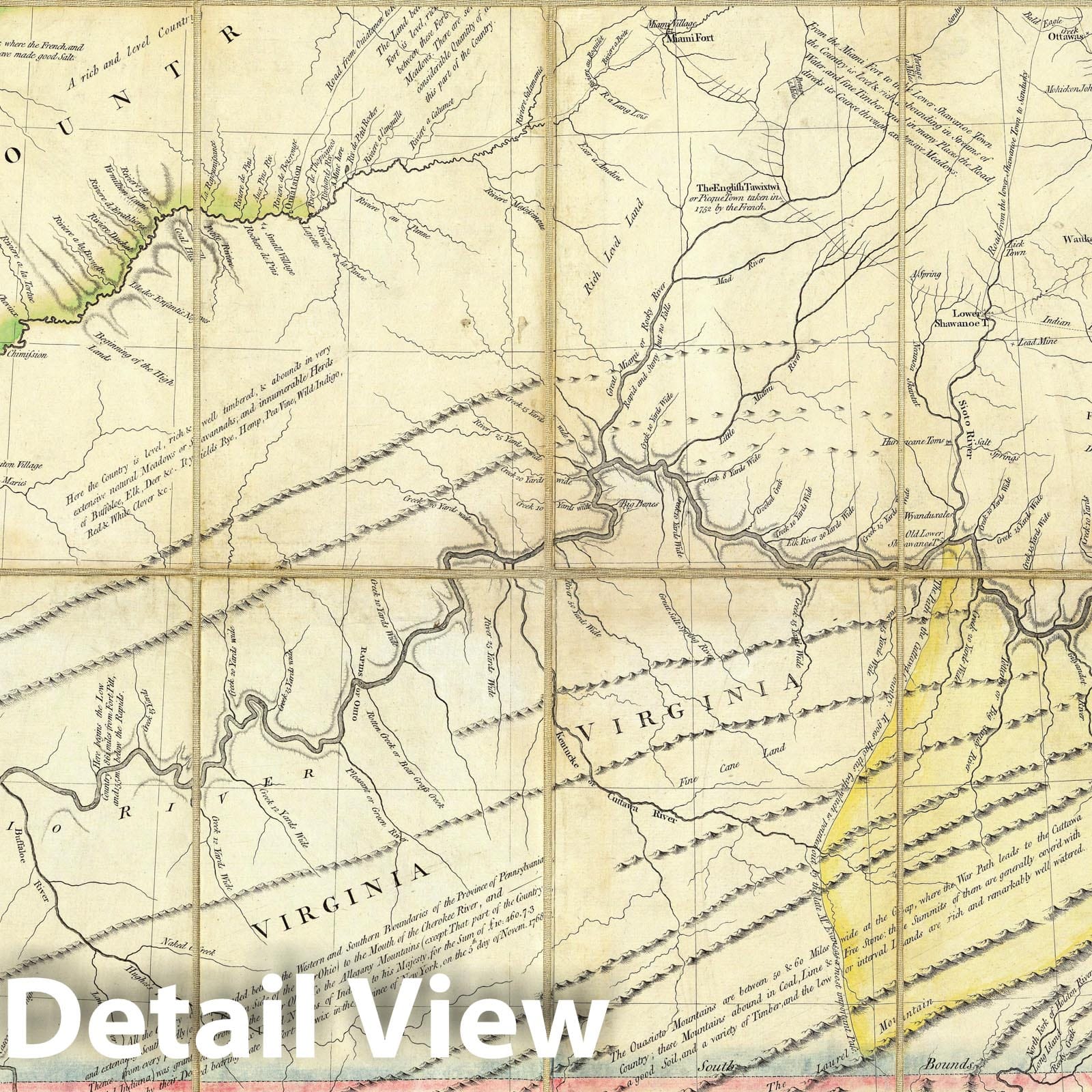
A New Map of the Western Parts of Virginia, Pennsylvania, Maryland and North Carolina; Comprehending the River Ohio, and all the Rivers, which fall into it; Part of the River Mississippi, the Whole of the Illinois River, Lake Erie; Part of the Lakes Huron, Michigan &c. And all the Country bordering on these Lakes and Rivers. By Thos. Hutchins, Captain in the 60 Regiment of Foot. London, Published according to Act of Parliament Novembr. ye 1st, 1778 by T. Hutchins ... Engrav'd by T. Cheevers. | A New Map of the Western Parts of Virginia, Pennsylvania, Maryland and North Carolina; Comprehending the River Ohio, and all the Rivers, which fall into it; Part of the River Mississippi, the Whole of the Illinois River, Lake Erie; Part of the Lakes Huron, Michigan &c. And all the Country bordering on these Lakes and Rivers. By Thos. Hutchins, Captain in the 60 Regiment of Foot. London, Published according to Act of Parliament Novembr. ye 1st, 1778 by T. Hutchins ... Engrav'd by T. Cheevers. | This map was published separately and at the same time as Hutchins' "Topographical Description..." and should accompany the book. Streeter calls it "by far the best map of the west printed to that time." It was the first large scale map of the area west of the Allegheny Mountains based on personal observations, although Hutchins gives credit to Lewis Evans' "Map of the Middle Colonies" as the best prior source of information about the area. The map contains extensive printed notes which describe important aspects of the country depicted. This map ranks with the most important American maps issued in the 18th century and is now rare. Hutchins later became the first Geographer of the United States. With outline color. Map is dissected into 32 sections and mounted on linen. Folds into new green cloth folding boards and quarter leather green cloth slip case 24x16 with "Hutchin's New Map Of Western Parts Of Virginia, Etc. 1778" on the spine in gold.
- MUSEUM QUALITY INKS AND PAPER: Printed on thick 192gsm heavyweight matte paper with archival giclee inks, this historic fine art will decorate your wall for years to come.
- VINTAGE MAP REPRODUCTION: Add style to any room's decor with this beautiful print. Whether your interior design is modern or classic, a map is never out of fashion.
- ATTENTION TO DETAIL: We edit every antique map for image quality, color and vibrance, so it can look its best while retaining historical character. Makes a great gift!
- FRAME READY: Your unframed poster will arrive crease-free, rolled in a sturdy mailing tube. Many maps fit easy-to-find standard size frames 16x20, 16x24, 18x24, 24x30, 24x36, saving on custom framing.
- Watermarks will not appear in the printed picture. Some blemishes, tears, or stamps may be removed from the final print.
Why choose Historic Pictoric
Every artwork we offer is carefully edited by our small but dedicated team of image professionals, ensuring each detail is perfect. We print every order to demand right here in the USA, treating every piece with the same care and attention we would give our own work. From editing to printing to packaging, we take pride in delivering artwork that meets our high standards—and we love knowing it’s heading to a home where it will be appreciated.
- Choosing a selection results in a full page refresh.
- Opens in a new window.