-
-


-
Wall Color
in
Uncheck to hide the white line Check to show the white line -
-
.


Frame
Room
Gallery
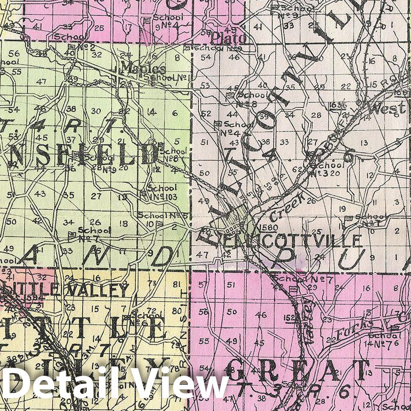
Historic Map : Century Map of Cattaraugus County, New York, 1912, Vintage Wall Art
Historic Map : Century Map of Cattaraugus County, New York, 1912, Vintage Wall Art
Note: Sold out or unavailable
Couldn't load pickup availability
A highly appealing 1912 large format folio map of Cattaraugus County, New York, issued for the New Century Atlas of Counties of the State of New York. The map covers from Perrysburg to Portville, including Dayton, Leon, Connewango, Randolph, South Valley, Elko, Cold Springs, Napoli, Albion, Persia, Otto, East Otto, Ashford, Mansfield, Little Valley, Salamanca, Red House, Carrollton, Great Valley, Ellicottville, Ashford, Yorkshire, Machias, Franklinville, Humphrey, Allegany, Olean, Portville, Hinsdale, Ischua, Lyndon, Farmersville and Freedom. There is appealing detail throughout with the roads, towns, and railroad lines clearly represented. Various communities are identified with larger districts highlighted in vivid pastels. This map was issued as plate nos. 48 and 49 in Everts' New Century Atlas of Counties of the State of New York.
- MUSEUM QUALITY INKS AND PAPER: Printed on thick 192gsm heavyweight matte paper with archival giclee inks, this historic fine art will decorate your wall for years to come.
- VINTAGE MAP REPRODUCTION: Add style to any room's decor with this beautiful print. Whether your interior design is modern or classic, a map is never out of fashion.
- ATTENTION TO DETAIL: We edit every antique map for image quality, color and vibrance, so it can look its best while retaining historical character. Makes a great gift!
- FRAME READY: Your unframed poster will arrive crease-free, rolled in a sturdy mailing tube. Many maps fit easy-to-find standard size frames 16x20, 16x24, 18x24, 24x30, 24x36, saving on custom framing.
- Watermarks will not appear in the printed picture. Some blemishes, tears, or stamps may be removed from the final print.
Why choose Historic Pictoric
Every artwork we offer is carefully edited by our small but dedicated team of image professionals, ensuring each detail is perfect. We print every order to demand right here in the USA, treating every piece with the same care and attention we would give our own work. From editing to printing to packaging, we take pride in delivering artwork that meets our high standards—and we love knowing it’s heading to a home where it will be appreciated.