-
-


-
Wall Color
in
Uncheck to hide the white line Check to show the white line -
-
.


Frame
Room
Gallery
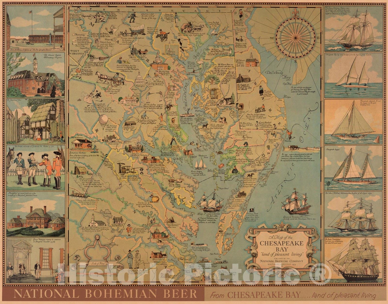
Historic Map - A map of the Chesapeake Bay :"land of pleasant living", 1959, - Vintage Wall Art
Historic Map - A map of the Chesapeake Bay :"land of pleasant living", 1959, - Vintage Wall Art
Note: Sold out or unavailable
Couldn't load pickup availability
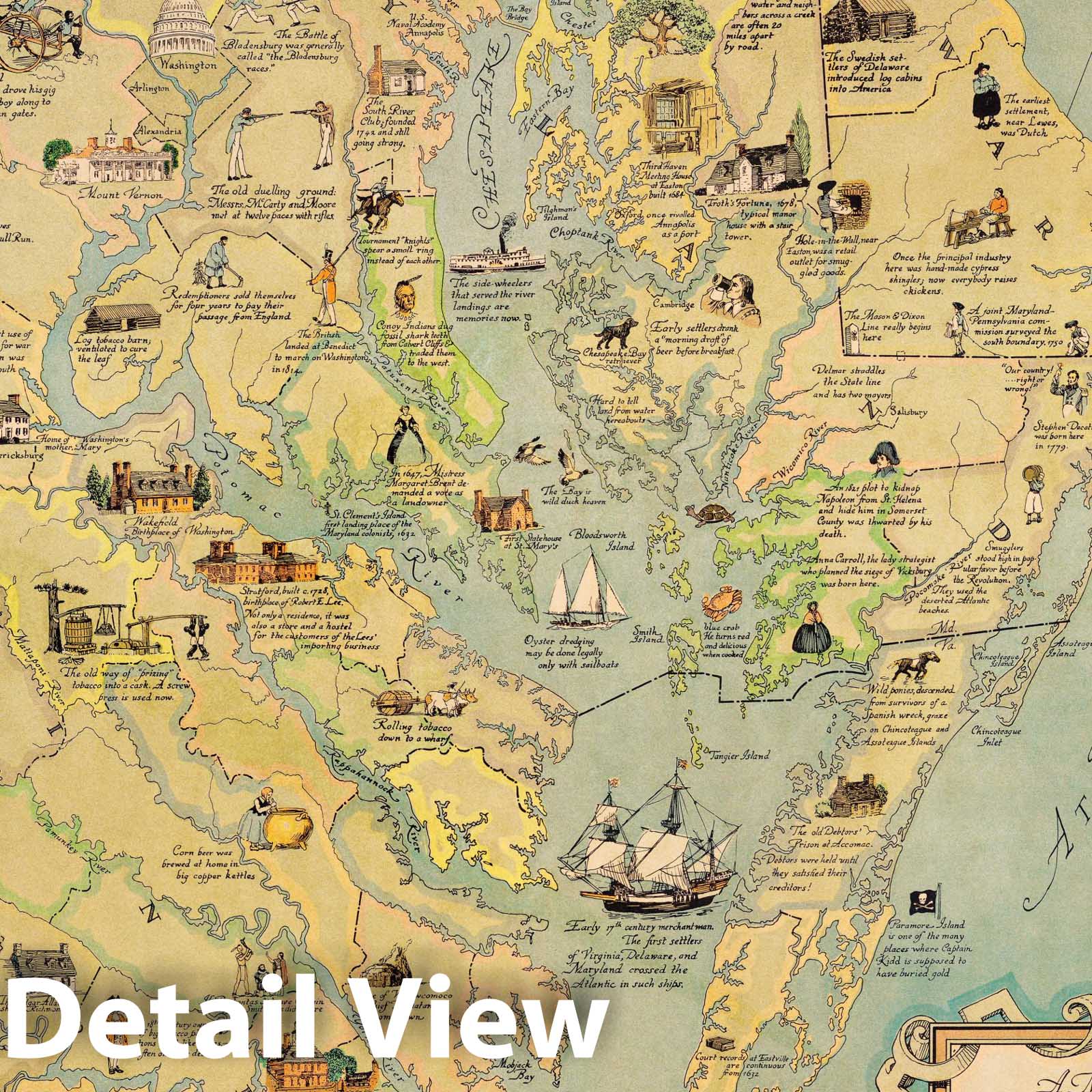
"A map of the Chesapeake Bay: Land of Pleasant Living" is a vibrant and colorful map that was published by the National Brewing Company in 1959. The map features the Chesapeake Bay and its surrounding areas, including parts of Maryland, Virginia, and Delaware. The map is filled with illustrations and interesting details, making it more than just a simple map. It features notable landmarks such as historic homes, lighthouses, and important battlefields. In addition, it showcases popular tourist attractions, fishing areas, and hunting grounds, as well as interesting facts about the history of the Chesapeake Bay and its role in the development of the United States.
This map is not only visually appealing, but it also serves as a historical artifact of the mid-20th century, as it was published during the post-World War II boom in tourism and the rise of the automobile. The National Brewing Company, based in Baltimore, Maryland, produced this map as a promotional item to entice tourists to visit the Chesapeake Bay area and to promote its popular beer brand, National Bohemian. The map features the slogan "Land of Pleasant Living," which became synonymous with the Chesapeake Bay region, and is a testament to the importance of beer in American culture and its influence on the advertising industry.
- MUSEUM QUALITY INKS AND PAPER: Printed on thick 192gsm heavyweight matte paper with archival giclee inks, this historic fine art will decorate your wall for years to come.
- VINTAGE MAP REPRODUCTION: Add style to any room's decor with this beautiful print. Whether your interior design is modern or classic, a map is never out of fashion.
- ATTENTION TO DETAIL: We edit every antique map for image quality, color and vibrance, so it can look its best while retaining historical character. Makes a great gift!
- FRAME READY: Your unframed poster will arrive crease-free, rolled in a sturdy mailing tube. Many maps fit easy-to-find standard size frames 16x20, 16x24, 18x24, 24x30, 24x36, saving on custom framing.
- Watermarks will not appear in the printed picture. Some blemishes, tears, or stamps may be removed from the final print.
Why choose Historic Pictoric
Every artwork we offer is carefully edited by our small but dedicated team of image professionals, ensuring each detail is perfect. We print every order to demand right here in the USA, treating every piece with the same care and attention we would give our own work. From editing to printing to packaging, we take pride in delivering artwork that meets our high standards—and we love knowing it’s heading to a home where it will be appreciated.