-
-


-
Wall Color
in
Uncheck to hide the white line Check to show the white line -
-
.


Frame
Room
Gallery
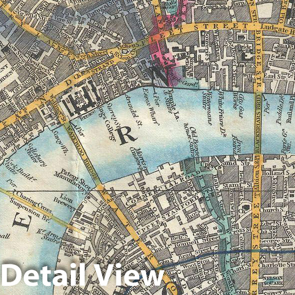
Historic Map : Crutchley Pocket Map or Plan of London, England, 1848, Vintage Wall Art
Historic Map : Crutchley Pocket Map or Plan of London, England, 1848, Vintage Wall Art
Note: Sold out or unavailable
Couldn't load pickup availability
This is a very attractive example of G. F. Cruchley's highly desirable 1848 Map of London, England. Covers London from Hyde Park in the west to the London Docks in the east. Extends north to include all of Regents Park and south as far as the South Western Terimini and Vauxhill Gardens. Offers full and color and detail to the street level with individual buildings noted. Map surrounded on left, right and bottom by a street by street index of the city. Title area to center. Backed on linen and bounded into its original linen folder. Cruchley issued various editions of this map from 1827. This issue, 1848, is not in the Hogwego catalogue and is one of the rarest.
- MUSEUM QUALITY INKS AND PAPER: Printed on thick 192gsm heavyweight matte paper with archival giclee inks, this historic fine art will decorate your wall for years to come.
- VINTAGE MAP REPRODUCTION: Add style to any room's decor with this beautiful print. Whether your interior design is modern or classic, a map is never out of fashion.
- ATTENTION TO DETAIL: We edit every antique map for image quality, color and vibrance, so it can look its best while retaining historical character. Makes a great gift!
- FRAME READY: Your unframed poster will arrive crease-free, rolled in a sturdy mailing tube. Many maps fit easy-to-find standard size frames 16x20, 16x24, 18x24, 24x30, 24x36, saving on custom framing.
- Watermarks will not appear in the printed picture. Some blemishes, tears, or stamps may be removed from the final print.
Why choose Historic Pictoric
Every artwork we offer is carefully edited by our small but dedicated team of image professionals, ensuring each detail is perfect. We print every order to demand right here in the USA, treating every piece with the same care and attention we would give our own work. From editing to printing to packaging, we take pride in delivering artwork that meets our high standards—and we love knowing it’s heading to a home where it will be appreciated.