-
-


-
Wall Color
in
Uncheck to hide the white line Check to show the white line -
-
.


Frame
Room
Gallery
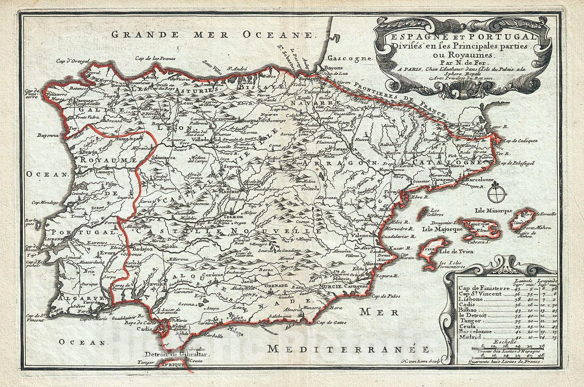
Historic Map : De Fer Map of Spain and Portugal, 1701, Vintage Wall Art
Historic Map : De Fer Map of Spain and Portugal, 1701, Vintage Wall Art
Note: Sold out or unavailable
Couldn't load pickup availability
This is a beautiful 1701 map of Spain and Portugal by Nicholas De Fer. It covers the Iberian Peninsula as well as adjacent parts of France and Africa and prominently displays the Balearic Islands of Majorca, Minorca, and Ibiza. The map renders the entire region in extraordinary detail offering both topographical and political information with mountains beautifully rendered in profile.
Spain at this time was witnessing the War of the Spanish Succession. After the death of the Spanish Habsburg King Charles II, the Spanish crown passed onto his successor Prince Philip of Anjou. Fearing that a union between France and Spain would threaten the balance of power in Europe, the Grand Alliance of the Holy Roman Empire, Portugal, Dutch Republic and the Duchy of Savoy declared war claiming the Spanish throne for Archduke Charles of Austria instead of Philip. In 1711, when the Austrian Emperor Joseph I died leaving Archduke Charles as his successor, an even greater threat of an Austrian-Spanish Alliance loomed if Charles were to claim the throne to both Austria and Spain. The war would end in 1714 with the signing of the treaties of Utrecht, Rastatt and Baden. Philip would become King of Spain after all, on the condition that he is removed from the French line of succession. Spain lost many of its territories and granted Great Britain asiento. This map was engraved by Harmanus van Loon and created by Nicholas De Fer for his 1701 Atlas.
- MUSEUM QUALITY INKS AND PAPER: Printed on thick 192gsm heavyweight matte paper with archival giclee inks, this historic fine art will decorate your wall for years to come.
- VINTAGE MAP REPRODUCTION: Add style to any room's decor with this beautiful print. Whether your interior design is modern or classic, a map is never out of fashion.
- ATTENTION TO DETAIL: We edit every antique map for image quality, color and vibrance, so it can look its best while retaining historical character. Makes a great gift!
- FRAME READY: Your unframed poster will arrive crease-free, rolled in a sturdy mailing tube. Many maps fit easy-to-find standard size frames 16x20, 16x24, 18x24, 24x30, 24x36, saving on custom framing.
- Watermarks will not appear in the printed picture. Some blemishes, tears, or stamps may be removed from the final print.
What our customers are saying
★★★★★I purchased an historic map, 16x24 inch. It is beautifully printed on heavy stock. The lettering, colors, and details of the map are crisp and easy to read. I am highly satisfied and would certainly purchase from Historic Pictoric again!
Kent A.
★★★★★Ordered the Pan American Midway print to fit a lovely thrift-store gilded frame. I love showing off Buffalo's rich history and this is a pretty entertaining photo from 1901. Prompt shipping. Sturdy packaging.
Cindy O.
★★★★★I received my print within days of ordering, and it arrived well packed in a mailing tube. The print is high quality and exactly as advertised. I will use Historic Pictoric again in the future!
Cheryl H.
★★★★★Excellent product. Great fidelity in reproduction of the original. Fine/minute details were sharp, colors were vibrant, and thickness, texture and overall feel and quality of the paper were excellent. Very satisfied with my purchase.
Konrad B.
★★★★★I have purchased six maps from Historic Pictoric. I find the quality to be excellent. Their customers service is also excellent. Outstanding! I called to exchange a few for different sizes and I could not have asked for a better experience.
Aaron C.
★★★★★The original map I ordered lacked some of the detail that I had hoped for, but they responded with several more map possibilities to choose from. Excellent service- a far step beyond what anyone expects from online purchases.
Dan M.
★★★★★I am a owner of 5 maps from Historic Pictoric. From Okinawa, 1945, Europe 1940-1945 battle maps. Now they’re helping me with the battle of Gettysburg. These maps are so much superior to the map on a page in a book. I have framed two of them.
Steven Ko
★★★★★Great heavy paper quality and clarity of my nautical map. Will be a great addition to our home close to the beach!
Jennifer A