-
-


-
Wall Color
in
Uncheck to hide the white line Check to show the white line -
-
.


Frame
Room
Gallery
Historic Map : Delisle de Sales Map of West Africa (Expedition of Admiral Hanno of Carthage), 1770, Vintage Wall Art
Historic Map : Delisle de Sales Map of West Africa (Expedition of Admiral Hanno of Carthage), 1770, Vintage Wall Art
Note: Sold out or unavailable
Couldn't load pickup availability
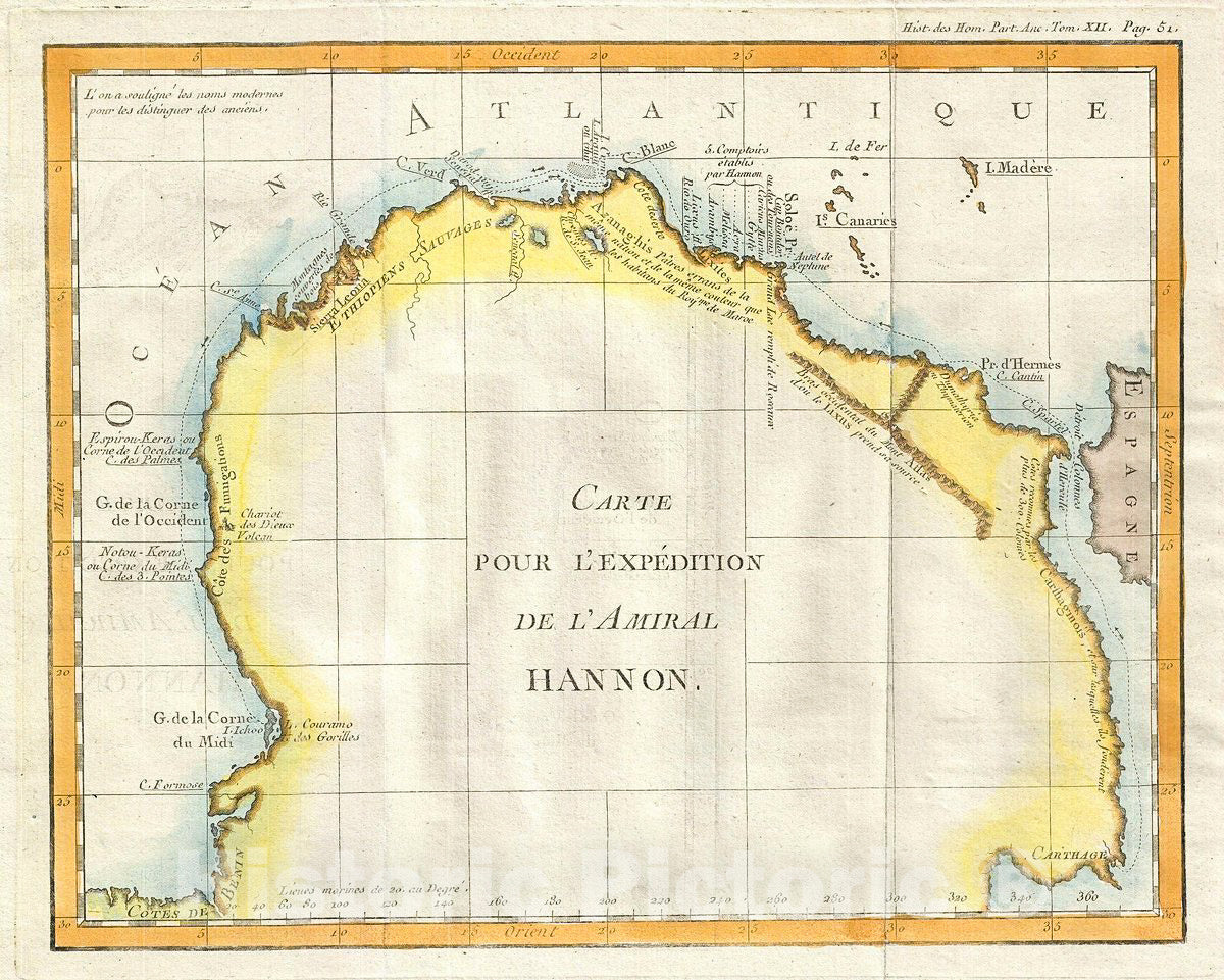
This is a fascinating example Jean-Baptiste-Claude Delisle de Sales' 1770 map of western Africa. Oriented to the west, this map covers northwest Africa from the coast of Benin to the Mediterranean Sea. This map depicts the journey of the ancient Carthaginian explorer Admiral Hanno (not to be confused with Hanno the Elder). Between 500 and 480 B.C. Carthage commissioned Hanno with siin xty ships and 30,000 sailor s to find (or found) trading colonies on the western coast of Africa. He recorded his expedition on a tablet entitled Periplus and on his return hung it in the temple of Ba'al Hammon (Kronos). The city of Thymiaterion, reportedly founded by Hanno, is identified along with various other locals referenced in the Periplus. This magnitude of Hanno's achievement can be best understood when compared with the struggles of the Portuguese 2000 years later to navigate the same stretch. Equipped with modern ships and advanced navigation techniques, it took Portuguese explorers nearly 100 years of only partially successful attempts to reach the Bight of Benin. Presumably for reference, the cartographer also identifies several more contemporary regions with updated place names, including the Canary Islands, Madeira, Spain, and Sierra Leone, to name just a few. Several rivers, mountains, and other topographical details are also noted. This map was issued as part of Delisle de Sales' Histoire des hommes. Partie de l'Histoire Ancienne. Becasue most of Sales' work was burnt under the censorship of heresy, this volume is exceedingly rare.
- MUSEUM QUALITY INKS AND PAPER: Printed on thick 192gsm heavyweight matte paper with archival giclee inks, this historic fine art will decorate your wall for years to come.
- VINTAGE MAP REPRODUCTION: Add style to any room's decor with this beautiful print. Whether your interior design is modern or classic, a map is never out of fashion.
- ATTENTION TO DETAIL: We edit every antique map for image quality, color and vibrance, so it can look its best while retaining historical character. Makes a great gift!
- FRAME READY: Your unframed poster will arrive crease-free, rolled in a sturdy mailing tube. Many maps fit easy-to-find standard size frames 16x20, 16x24, 18x24, 24x30, 24x36, saving on custom framing.
- Watermarks will not appear in the printed picture. Some blemishes, tears, or stamps may be removed from the final print.
What our customers are saying
★★★★★I purchased an historic map, 16x24 inch. It is beautifully printed on heavy stock. The lettering, colors, and details of the map are crisp and easy to read. I am highly satisfied and would certainly purchase from Historic Pictoric again!
Kent A.
★★★★★Ordered the Pan American Midway print to fit a lovely thrift-store gilded frame. I love showing off Buffalo's rich history and this is a pretty entertaining photo from 1901. Prompt shipping. Sturdy packaging.
Cindy O.
★★★★★I received my print within days of ordering, and it arrived well packed in a mailing tube. The print is high quality and exactly as advertised. I will use Historic Pictoric again in the future!
Cheryl H.
★★★★★Excellent product. Great fidelity in reproduction of the original. Fine/minute details were sharp, colors were vibrant, and thickness, texture and overall feel and quality of the paper were excellent. Very satisfied with my purchase.
Konrad B.
★★★★★I have purchased six maps from Historic Pictoric. I find the quality to be excellent. Their customers service is also excellent. Outstanding! I called to exchange a few for different sizes and I could not have asked for a better experience.
Aaron C.
★★★★★The original map I ordered lacked some of the detail that I had hoped for, but they responded with several more map possibilities to choose from. Excellent service- a far step beyond what anyone expects from online purchases.
Dan M.
★★★★★I am a owner of 5 maps from Historic Pictoric. From Okinawa, 1945, Europe 1940-1945 battle maps. Now they’re helping me with the battle of Gettysburg. These maps are so much superior to the map on a page in a book. I have framed two of them.
Steven Ko
★★★★★Great heavy paper quality and clarity of my nautical map. Will be a great addition to our home close to the beach!
Jennifer A