-
-


-
Wall Color
in
Uncheck to hide the white line Check to show the white line -
-
.


Frame
Room
Gallery
Historic Map : Doughty Map of North West Arabia (Saudi Arabia), 1883, Vintage Wall Art
Historic Map : Doughty Map of North West Arabia (Saudi Arabia), 1883, Vintage Wall Art
Note: Sold out or unavailable
Couldn't load pickup availability
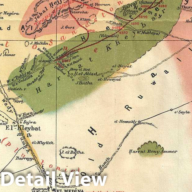
This is an interesting 1883 map of northwestern Arabia or modern day Saudi Arabia by Charles M. Doughty. It covers from Mecca (Medina) north to Eilat including the Gulf of Aqaba and inland as far as Buraydah. Throughout, the map notes important towns, geology, ruins, camps, water stations and topography. The route followed by Charles Doughty is marked in red. An inset in the lower left quadrant depicts the north part of Arabia from the Gulf of Aqaba north past the Dead Sea to Jarash. Three sections showing the geological constitution of the Peninsula of Arabia are featured along the right margin.
The map depicts the journey of the English poet, writer, and traveller Charles M. Doughty. Doughty traveled in Arabia from November 1876 to August 1878 and in Paraea on the eastern side of the Jordan River Valley in May and June of 1875. During his travels, he lived amongst the Bedu, giving him one of the closest western looks at Arab life during the time. His book Travels in Arabia Deserta, from where this map comes from, is considered to be a one of the finest examples of travel writing of its time. It relates Doughty's treks and discoveries through the Arabian desert.
This map was issued as part of the 1926 edition of Charles M. Doughty's Travels in Arabia Deserta.
Why choose Historic Pictoric
Every artwork we offer is carefully edited by our small but dedicated team of image professionals, ensuring each detail is perfect. We print every order to demand right here in the USA, treating every piece with the same care and attention we would give our own work. From editing to printing to packaging, we take pride in delivering artwork that meets our high standards—and we love knowing it’s heading to a home where it will be appreciated.
- MUSEUM QUALITY INKS AND PAPER: Printed on thick 192gsm heavyweight matte paper with archival giclee inks, this historic fine art will decorate your wall for years to come.
- VINTAGE MAP REPRODUCTION: Add style to any room's decor with this beautiful print. Whether your interior design is modern or classic, a map is never out of fashion.
- ATTENTION TO DETAIL: We edit every antique map for image quality, color and vibrance, so it can look its best while retaining historical character. Makes a great gift!
- FRAME READY: Your unframed poster will arrive crease-free, rolled in a sturdy mailing tube. Many maps fit easy-to-find standard size frames 16x20, 16x24, 18x24, 24x30, 24x36, saving on custom framing.
- Watermarks will not appear in the printed picture. Some blemishes, tears, or stamps may be removed from the final print.
What our customers are saying
★★★★★I purchased an historic map, 16x24 inch. It is beautifully printed on heavy stock. The lettering, colors, and details of the map are crisp and easy to read. I am highly satisfied and would certainly purchase from Historic Pictoric again!
Kent A.
★★★★★The deliverable was even better than the picture on the website. Was able to use it as a great show and tell this past Memorial Day (and two of the folks are my retired geology professors)!
Edward D.
★★★★★Ordered the Pan American Midway print to fit a lovely thrift-store gilded frame. I love showing off Buffalo's rich history and this is a pretty entertaining photo from 1901. Prompt shipping. Sturdy packaging.
Cindy O.
★★★★★I received my print within days of ordering, and it arrived well packed in a mailing tube. The print is high quality and exactly as advertised. I will use Historic Pictoric again in the future!
Cheryl H.
★★★★★Excellent product. Great fidelity in reproduction of the original. Fine/minute details were sharp, colors were vibrant, and thickness, texture and overall feel and quality of the paper were excellent. Very satisfied with my purchase.
Konrad B.
★★★★★I have purchased six maps from Historic Pictoric. I find the quality to be excellent. Their customers service is also excellent. Outstanding! I called to exchange a few for different sizes and I could not have asked for a better experience.
Aaron C.
★★★★★The original map I ordered lacked some of the detail that I had hoped for, but they responded with several more map possibilities to choose from. Excellent service- a far step beyond what anyone expects from online purchases.
Dan M.
★★★★★I am a owner of 5 maps from Historic Pictoric. From Okinawa, 1945, Europe 1940-1945 battle maps. Now they’re helping me with the battle of Gettysburg. These maps are so much superior to the map on a page in a book. I have framed two of them.
Steven K.
★★★★★Great heavy paper quality and clarity of my nautical map. Will be a great addition to our home close to the beach!
Jennifer A