-
-


-
Wall Color
in
Uncheck to hide the white line Check to show the white line -
-
.


Frame
Room
Gallery
Historic Map : First Japanese Buddhist Map of The World Showing Europe, America, and Africa , 1710, Vintage Wall Art
Historic Map : First Japanese Buddhist Map of The World Showing Europe, America, and Africa , 1710, Vintage Wall Art
Note: Sold out or unavailable
Couldn't load pickup availability
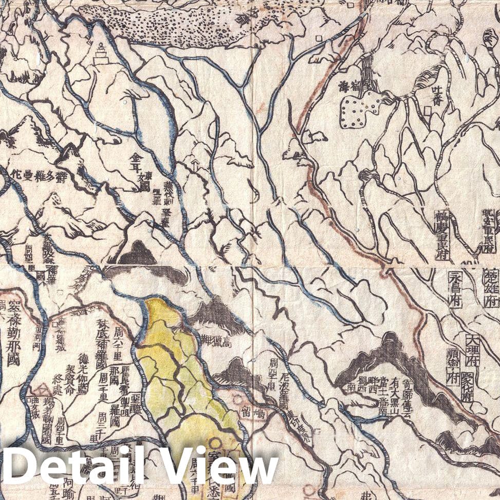
A seminal map. This is the first Japanese printed map to depict the world, including Europe and America, from a Buddhist cosmographical perspective. Printed by woodblock in 1710 (Hoei 7), this map was composed by the Buddhist monk Rokashi Hotan. Inspired by the 1653 publication of Si-yu-ki, a pilgrimage narrative of the Chinese monk Hsuang-Tsang's (602-604) travels to India in search of sacred Sanskrit writings, Rokashi Hotan's map attempts to update Buddhist mythological cartography, as exemplified in the 1634 manuscript map Gotenjikuzu (Map of the Five Regions of India), to correspond with the Si-yu-ki, as well as with contemporary and ancient religious texts, Chinese annals, travel narratives, and even some European maps. Rokashi Hotan lists these texts, 102 in all, at the top of the map. The consequent product of Rokashi Hotan's work is this magnificent amalgam of disparate ideas and traditions. In essence this is a traditional Buddhist world view in the Gotenjikuzu mold centered on the world spanning continent of Jambu-Dvipa. At its center is Lake Anavatapta, a whirlpool-like quadruple helix lake believed to be the center of the universe. This lake, which is commonly associated with Lake Manasarovar in northern India, is believed in Buddhist mythology to be the legendary site where Queen Maya conceived the Buddha. While this map represents a significant step forward in the Japanese attempt to combine religious and contemporary geographic knowledge it remains in essence a Buddhist map. It is likely that Rokashi Hotan was aware important European style maps circulating in China at the time. The Mateo Ricci Map is one such example and copies were known to have reached Japan in the 17th century. It is curious that Rokashi Hotan chose to ignore it and other Eurocentric data in exchange for a religious world view, while at the same time attempting to reconcile Buddhist and modern geography.
- MUSEUM QUALITY INKS AND PAPER: Printed on thick 192gsm heavyweight matte paper with archival giclee inks, this historic fine art will decorate your wall for years to come.
- VINTAGE MAP REPRODUCTION: Add style to any room's decor with this beautiful print. Whether your interior design is modern or classic, a map is never out of fashion.
- ATTENTION TO DETAIL: We edit every antique map for image quality, color and vibrance, so it can look its best while retaining historical character. Makes a great gift!
- FRAME READY: Your unframed poster will arrive crease-free, rolled in a sturdy mailing tube. Many maps fit easy-to-find standard size frames 16x20, 16x24, 18x24, 24x30, 24x36, saving on custom framing.
- Watermarks will not appear in the printed picture. Some blemishes, tears, or stamps may be removed from the final print.
Why choose Historic Pictoric
Every artwork we offer is carefully edited by our small but dedicated team of image professionals, ensuring each detail is perfect. We print every order to demand right here in the USA, treating every piece with the same care and attention we would give our own work. From editing to printing to packaging, we take pride in delivering artwork that meets our high standards—and we love knowing it’s heading to a home where it will be appreciated.