-
-


-
Wall Color
in
Uncheck to hide the white line Check to show the white line -
-
.


Frame
Room
Gallery
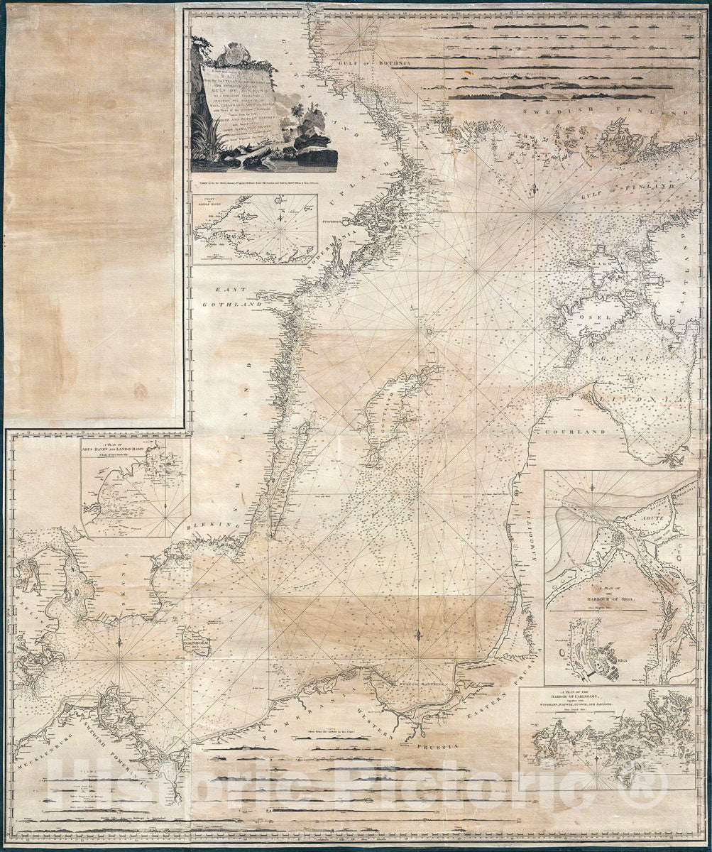
Historic Map : John Moore Map of Nautical Chart of The Baltic Sea, 1791, Vintage Wall Art
Historic Map : John Moore Map of Nautical Chart of The Baltic Sea, 1791, Vintage Wall Art
Note: Sold out or unavailable
Couldn't load pickup availability
Extremely rare, this is a 1791 wall sized nautical chart or maritime map of the Baltic Sea by John Hamilton Moore. The map covers from the Gulf of Bothinia and the coast of Finland south to Pomerania, Prussia, and the Kattegat, and from Denmark east to the Gulf of Livonia. In modern terms, this map covers the Baltic Sea in the vicinity of Sweden, Finland, Estonia, Latvia, Lithuania, Poland, Germany, and Denmark. There are several inset plans detailing the Harbor of Riga, the Harbor of Carlshamn, the city of Riga, Geffle Haven, and Ahus Haven / Lando Hamn. There are countless nautical sounding throughout and series of 26 sore profile views decorate the upper right and lower quadrants.
The large decorative title cartouche drawn and engraved by J. Stephenson appears in the upper left quadrants and exhibits a bucolic Scandinavian scene. One can only wonder if this is J. Stephenson is one in the same or a relative of the John Stephenson, a coal trade captain, who is known to have provided Moore nautical information to more that was eventually compiled into some of his more popular charts of the North Sea and Thames Estuary.
This chart is exceedingly scarce. We have identified only two other examples, one in the collection of the Bibliotheque Nationale de France, the other in the Biblioteca Nacional de Espana.
- MUSEUM QUALITY INKS AND PAPER: Printed on thick 192gsm heavyweight matte paper with archival giclee inks, this historic fine art will decorate your wall for years to come.
- VINTAGE MAP REPRODUCTION: Add style to any room's decor with this beautiful print. Whether your interior design is modern or classic, a map is never out of fashion.
- ATTENTION TO DETAIL: We edit every antique map for image quality, color and vibrance, so it can look its best while retaining historical character. Makes a great gift!
- FRAME READY: Your unframed poster will arrive crease-free, rolled in a sturdy mailing tube. Many maps fit easy-to-find standard size frames 16x20, 16x24, 18x24, 24x30, 24x36, saving on custom framing.
- Watermarks will not appear in the printed picture. Some blemishes, tears, or stamps may be removed from the final print.
What our customers are saying
★★★★★I purchased an historic map, 16x24 inch. It is beautifully printed on heavy stock. The lettering, colors, and details of the map are crisp and easy to read. I am highly satisfied and would certainly purchase from Historic Pictoric again!
Kent A.
★★★★★Ordered the Pan American Midway print to fit a lovely thrift-store gilded frame. I love showing off Buffalo's rich history and this is a pretty entertaining photo from 1901. Prompt shipping. Sturdy packaging.
Cindy O.
★★★★★I received my print within days of ordering, and it arrived well packed in a mailing tube. The print is high quality and exactly as advertised. I will use Historic Pictoric again in the future!
Cheryl H.
★★★★★Excellent product. Great fidelity in reproduction of the original. Fine/minute details were sharp, colors were vibrant, and thickness, texture and overall feel and quality of the paper were excellent. Very satisfied with my purchase.
Konrad B.
★★★★★I have purchased six maps from Historic Pictoric. I find the quality to be excellent. Their customers service is also excellent. Outstanding! I called to exchange a few for different sizes and I could not have asked for a better experience.
Aaron C.
★★★★★The original map I ordered lacked some of the detail that I had hoped for, but they responded with several more map possibilities to choose from. Excellent service- a far step beyond what anyone expects from online purchases.
Dan M.
★★★★★I am a owner of 5 maps from Historic Pictoric. From Okinawa, 1945, Europe 1940-1945 battle maps. Now they’re helping me with the battle of Gettysburg. These maps are so much superior to the map on a page in a book. I have framed two of them.
Steven Ko
★★★★★Great heavy paper quality and clarity of my nautical map. Will be a great addition to our home close to the beach!
Jennifer A