-
-


-
Wall Color
in
Uncheck to hide the white line Check to show the white line -
-
.


Frame
Room
Gallery
Historic Map : John Speed Map of Carolina, 1676, Vintage Wall Art
Historic Map : John Speed Map of Carolina, 1676, Vintage Wall Art
Note: Sold out or unavailable
Couldn't load pickup availability
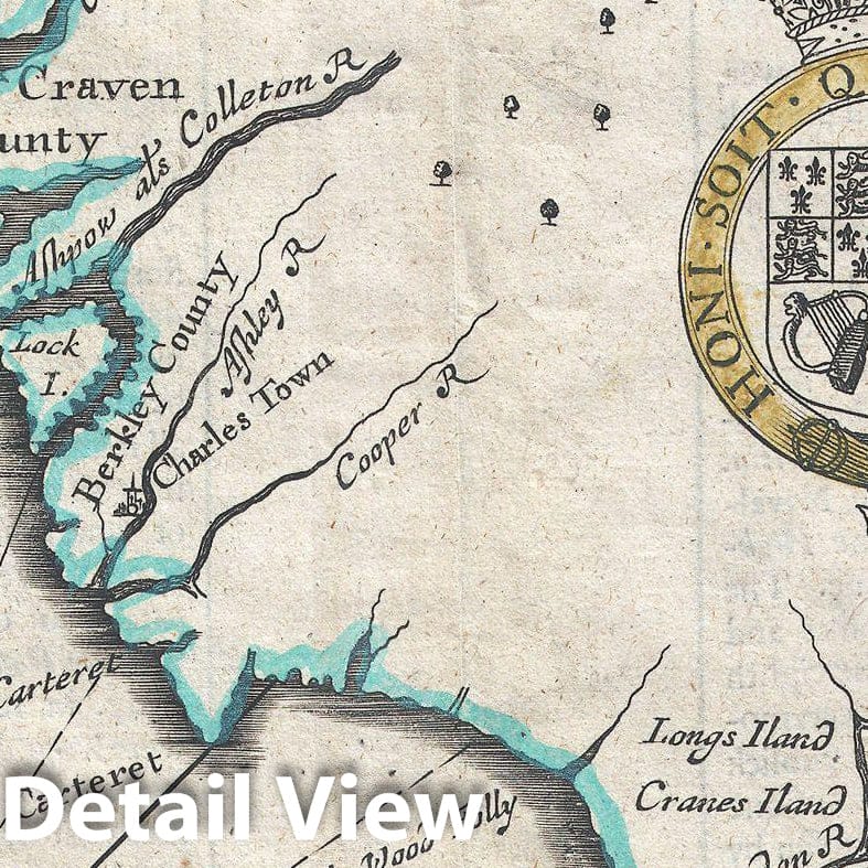
A beautiful example of John Speed's important 1676 map of the Carolina colony. Heavily based upon the explorations of John Lederer and Ogilby's Lords Proprietor's Map of 1674. This seminal map represents one of the earliest attempts to map the Carolina interior. Oriented to the West, map covers from the Spanish colony of St. Augustine, Florida, north to Jamestown, Virginia. Extends inland as far as the Appellation (Apalathean) Mountains. By the middle of the 17th century the coast of Carolina had been fairly well mapped , St. Augustine, Port Royal, Charleston (Charles Town), Cape Fear, Cape Lookout, Cape Hatteras, Roanoke, Cape Henry and the James River are all shown with a fair approximation of accuracy. Also shows the River May (historically either the St. John's River or the Savannah River, depending on the map). Where this map really gets interesting is the interior, which is heavily based upon the explorations of John Lederer in the 1670s. Lederer, a German physician who had moved to the colony several years before was commissioned by the Lord Proprietor, Anthony Ashley Cooper (Earl of Shaftesbury), to explore the interior in search of a pass beyond the mountains to the Pacific. As the time it was commonly assumed that the mainland of North America was a relatively narrow strip of land that could be traversed swiftly easily to access the rich trade opportunities of the Pacific. Keeping to a southwesterly course, Lederer passes a great savanna on his right and ultimately finds himself on the shores of Ashley Lake (which he calls Ushery and which on our map corresponds with the Great Freshwater Lake of the American Southwest popularized by the 1606 Mercator - Hondius Map). The savanna in the piedmont region is non-existent today, though something very much like this may have existed in Lederer's day. Lederer describes this savanna as marish grounds at the foot of the Apalataei.
- MUSEUM QUALITY INKS AND PAPER: Printed on thick 192gsm heavyweight matte paper with archival giclee inks, this historic fine art will decorate your wall for years to come.
- VINTAGE MAP REPRODUCTION: Add style to any room's decor with this beautiful print. Whether your interior design is modern or classic, a map is never out of fashion.
- ATTENTION TO DETAIL: We edit every antique map for image quality, color and vibrance, so it can look its best while retaining historical character. Makes a great gift!
- FRAME READY: Your unframed poster will arrive crease-free, rolled in a sturdy mailing tube. Many maps fit easy-to-find standard size frames 16x20, 16x24, 18x24, 24x30, 24x36, saving on custom framing.
- Watermarks will not appear in the printed picture. Some blemishes, tears, or stamps may be removed from the final print.
Why choose Historic Pictoric
Every artwork we offer is carefully edited by our small but dedicated team of image professionals, ensuring each detail is perfect. We print every order to demand right here in the USA, treating every piece with the same care and attention we would give our own work. From editing to printing to packaging, we take pride in delivering artwork that meets our high standards—and we love knowing it’s heading to a home where it will be appreciated.