-
-


-
Wall Color
in
Uncheck to hide the white line Check to show the white line -
-
.


Frame
Room
Gallery
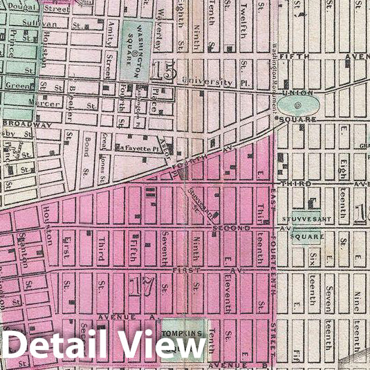
Historic Map : Johnson Map of New York City and Brooklyn, Version 2, 1865, Vintage Wall Art
Historic Map : Johnson Map of New York City and Brooklyn, Version 2, 1865, Vintage Wall Art
Note: Sold out or unavailable
Couldn't load pickup availability
A fine hand colored map of New York City and Brooklyn dating to 1865. Covers the island of Manhattan and the borough of Brooklyn as well as parts of Jersey City and Hoboken. Johnson's plan is heavily based upon the third state of J. H. Colton's New York City atlas map. Central Park is shown in great detail and in and earlier incarnation than we know today with the Receiving Reservoir in the place of today's Great Lawn. The important ferries running between New York, Brooklyn, Queens, and New Jersey, are all noted. In Queens we can see the newly built Long Island Railroad leaving Flushing station at Hunter's Point. At the tip of Roosevelt Island where now stands a decrepit ruin, there Johnson notes a civil war hospital. Represents Page no. 29 - 30 in the 1865 Johnson and Ward edition of Johnson's Family Atlas . This is the last edition of this map to bear the Johnson and Ward imprint.
- MUSEUM QUALITY INKS AND PAPER: Printed on thick 192gsm heavyweight matte paper with archival giclee inks, this historic fine art will decorate your wall for years to come.
- VINTAGE MAP REPRODUCTION: Add style to any room's decor with this beautiful print. Whether your interior design is modern or classic, a map is never out of fashion.
- ATTENTION TO DETAIL: We edit every antique map for image quality, color and vibrance, so it can look its best while retaining historical character. Makes a great gift!
- FRAME READY: Your unframed poster will arrive crease-free, rolled in a sturdy mailing tube. Many maps fit easy-to-find standard size frames 16x20, 16x24, 18x24, 24x30, 24x36, saving on custom framing.
- Watermarks will not appear in the printed picture. Some blemishes, tears, or stamps may be removed from the final print.
Why choose Historic Pictoric
Every artwork we offer is carefully edited by our small but dedicated team of image professionals, ensuring each detail is perfect. We print every order to demand right here in the USA, treating every piece with the same care and attention we would give our own work. From editing to printing to packaging, we take pride in delivering artwork that meets our high standards—and we love knowing it’s heading to a home where it will be appreciated.
- Choosing a selection results in a full page refresh.
- Opens in a new window.