-
-


-
Wall Color
in
Uncheck to hide the white line Check to show the white line -
-
.


Frame
Room
Gallery
Historic Map : Manuscript Map of The Ancient World: Europe, Asia and Africa, 1823, Vintage Wall Art
Historic Map : Manuscript Map of The Ancient World: Europe, Asia and Africa, 1823, Vintage Wall Art
Note: Sold out or unavailable
Couldn't load pickup availability
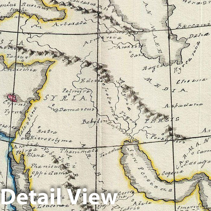
An unusual and beautiful 1823 manuscript map of The Ancient World, including Asia, europe and Africa. The map generally follows the historical atlas work of the english cartographer James Wyld however is a fully independent and unique hand rendered production. The manuscript geographical data and detail throughout is altogether outstanding and completed in a fine hand adept at decorative text and the rendering of rivers and mountains.
The map shows the world of classical antiquity from the Atlantic Ocean to Southeast Asia and from the Indian Ocean to the North Sea. It includes all of europe, Arabia, parts of Asia, including the Indian Subcontinent, and the northern parts of Africa. Color coding divides the ma by continent. Throughout there are interesting notations such as, in Africa, the 'Aethiopes Anthroophagi,' the city of Rapta identified by Ptolemy as the southernmost city, and the apocryphal Lune Montes in Africa
An altogether unique and wonderful one of a kind find.
- MUSEUM QUALITY INKS AND PAPER: Printed on thick 192gsm heavyweight matte paper with archival giclee inks, this historic fine art will decorate your wall for years to come.
- VINTAGE MAP REPRODUCTION: Add style to any room's decor with this beautiful print. Whether your interior design is modern or classic, a map is never out of fashion.
- ATTENTION TO DETAIL: We edit every antique map for image quality, color and vibrance, so it can look its best while retaining historical character. Makes a great gift!
- FRAME READY: Your unframed poster will arrive crease-free, rolled in a sturdy mailing tube. Many maps fit easy-to-find standard size frames 16x20, 16x24, 18x24, 24x30, 24x36, saving on custom framing.
- Watermarks will not appear in the printed picture. Some blemishes, tears, or stamps may be removed from the final print.
Why choose Historic Pictoric
Every artwork we offer is carefully edited by our small but dedicated team of image professionals, ensuring each detail is perfect. We print every order to demand right here in the USA, treating every piece with the same care and attention we would give our own work. From editing to printing to packaging, we take pride in delivering artwork that meets our high standards—and we love knowing it’s heading to a home where it will be appreciated.