-
-


-
Wall Color
in
Uncheck to hide the white line Check to show the white line -
-
.


Frame
Room
Gallery
Historic Map : Mason Plan or Map of Cambridge, Massachusetts, 1878, Vintage Wall Art
Historic Map : Mason Plan or Map of Cambridge, Massachusetts, 1878, Vintage Wall Art
Note: Sold out or unavailable
Couldn't load pickup availability
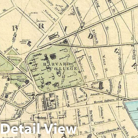
This is a scarce and beautiful 1878 map of the city of Cambridge Massachusetts by W. A. Mason and Sons. Centered on Harvard College, cover Cambridge north of the Charles River extending from Fresh Pond to what is today Gilmore Bridge (Prison Point Bridge at the time). The map is color-coded according to wards and notes radical distances from City Hall. Incredibly detailed, parks, streets, important buildings, ponds, and railroads are also noted. Shows the proposed extensions in the east.
This map was prepared by W. A. Mason and Sons. Copyrighted by W. A. Greenough in 1877, this is the 1878 edition published by Greenough and Company. We only know of two editions of this map ever issued – the first in 1878 and the second in 1881. Furthermore, only two known examples of this particular 1878 edition are known, one with Harvard College Library and the other with the University of Massachusetts, Amherst, making this a scarce find.
- MUSEUM QUALITY INKS AND PAPER: Printed on thick 192gsm heavyweight matte paper with archival giclee inks, this historic fine art will decorate your wall for years to come.
- VINTAGE MAP REPRODUCTION: Add style to any room's decor with this beautiful print. Whether your interior design is modern or classic, a map is never out of fashion.
- ATTENTION TO DETAIL: We edit every antique map for image quality, color and vibrance, so it can look its best while retaining historical character. Makes a great gift!
- FRAME READY: Your unframed poster will arrive crease-free, rolled in a sturdy mailing tube. Many maps fit easy-to-find standard size frames 16x20, 16x24, 18x24, 24x30, 24x36, saving on custom framing.
- Watermarks will not appear in the printed picture. Some blemishes, tears, or stamps may be removed from the final print.
Why choose Historic Pictoric
Every artwork we offer is carefully edited by our small but dedicated team of image professionals, ensuring each detail is perfect. We print every order to demand right here in the USA, treating every piece with the same care and attention we would give our own work. From editing to printing to packaging, we take pride in delivering artwork that meets our high standards—and we love knowing it’s heading to a home where it will be appreciated.